Jump to content


Main menu


Navigation  


Main page
Contents
Current events
Random article
About Wikipedia
Contact us
Donate


Contribute  


Help
Learn to edit
Community portal
Recent changes
Upload file


Search  


Create account

Log in


Create account
 Log in


Pages for logged out editors learn more  


Contributions
Talk


Contents


(Top)


1 Geography  


2 Earthquakes  


3 See also  


4 References  


Moro Gulf


العربية
تۆرکجه
Bikol Central
Български
Bosanski
Cebuano
Deutsch
Español
Euskara
Français

Hrvatski
Ilokano
Bahasa Indonesia
Íslenska
Italiano
Kiswahili
Latviešu
Македонски

Nederlands

Norsk bokmål
Polski
Português
Русский
Srpskohrvatski / српскохрватски
Tagalog
Tiếng Vit
Winaray


Edit links


Article
Talk


Read
Edit
View history


Tools


Actions  


Read
Edit
View history


General  


What links here
Related changes
Upload file
Special pages
Permanent link
Page information
Cite this page
Get shortened URL
Download QR code
Wikidata item


Print/export  


Download as PDF
Printable version


Appearance


Coordinates: 6°5100N 123°0000E / 6.8500°N 123.0000°E / 6.8500; 123.0000
 

From Wikipedia, the free encyclopedia


Moro Gulf
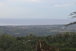
The gulf seen from Lebak
Moro Gulf is located in Mindanao
Moro Gulf

Moro Gulf

Location within the Philippines

Moro Gulf is located in Philippines
Moro Gulf

Moro Gulf

Moro Gulf (Philippines)

LocationMindanao Island
Coordinates6°51′00N 123°00′00E / 6.8500°N 123.0000°E / 6.8500; 123.0000
TypeGulf
EtymologyMoro
Part ofCelebes Sea
Basin countriesPhilippines
Settlements
  • Balabagan
  • Buug
  • Cotabato City
  • Datu Blah T. Sinsuat
  • Datu Odin Sinsuat
  • Dimataling
  • Dinas
  • Dumalinao
  • Hadji Mohammad Ajul
  • Ipil
  • Kabasalan
  • Kalamansig
  • Kapatagan
  • Kumalarang
  • Labangan
  • Lapuyan
  • Lebak
  • Mabuhay
  • Malabang
  • Malangas
  • Margosatubig
  • Matanog
  • Naga
  • Olutanga
  • Pagadian
  • Palimbang
  • Parang
  • Payao
  • Picong
  • Pitogo
  • Roseller Lim
  • San Pablo
  • Siay
  • Sultan Mastura
  • Sultan Naga Dimaporo
  • Tabina
  • Talusan
  • Tukuran
  • Tungawan
  • Vincenzo A. Sagun
  • Zamboanga City
  • The Moro Gulf is the largest gulf in the Philippines. It is located off the coast of Mindanao Island, and is part of the Celebes Sea. The gulf is one of the country's tuna fishing grounds.[1]

    Geography[edit]

    The gulf stretches between and is surrounded by the main section of Mindanao on the east, and the Zamboanga Peninsula of Mindanao on the west. The peninsula's major drainage goes towards the gulf.[2]

    Sibuguey Bay and Illana Bay are its major bays.

    Zamboanga City, which is an international port, is bound by the Gulf and Celebes Sea in the East.[3] Cotabato City, on the eastern coast, is another major port.

    Earthquakes[edit]

    The Moro Gulf is also an area of significant tectonic activity with several fault zones in the region capable of producing major earthquakes and destructive local tsunamis, such as the devastating 1976 Moro Gulf earthquake which killed over 5,000 people and left over 90,000 people homeless as it hit the west coast of Mindanao.

    Earthquakes in Mindanao
    Moro Gulf

    Moro Gulf

    1918
    1976
    2002
    The two largest 20th century Philippine earthquakes: the 1918 Celebes Sea earthquake (8.3 Mw) and the 1976 Moro Gulf earthquake (8.0 Mw). The relatively large 2002 Mindanao earthquake (7.5 Mw) also occurred in the area. The Moro Gulf, part of the Celebes Sea, is labeled for context.

    See also[edit]

    References[edit]

    1. ^ Barut, Noel. "National Tuna Fishery Report - Philippines" (PDF). School of Ocean and Earth Science and Technology. Marine Fisheries Research Division National Fisheries Research and Development Institute. Retrieved May 4, 2015.
  • ^ Carating, Rodelio B. (2014). Soils of the Philippines: World soils book series. Springer Science & Business. p. 61. ISBN 978-9401786829. Retrieved May 4, 2015.
  • ^ "ZAMBOANGA PENINSULA". Department of Environment and Natural Resources. Archived from the original on August 15, 2018. Retrieved May 4, 2015.

  • t
  • e

  • Retrieved from "https://en.wikipedia.org/w/index.php?title=Moro_Gulf&oldid=1176822630"

    Categories: 
    Gulfs of the Philippines
    Bodies of water of the Celebes Sea
    Landforms of Sultan Kudarat
    Landforms of Lanao del Sur
    Landforms of Lanao del Norte
    Landforms of Zamboanga del Sur
    Landforms of Zamboanga Sibugay
    Landforms of Maguindanao del Norte
    Philippines geography stubs
    Hidden categories: 
    Pages using gadget WikiMiniAtlas
    Articles with short description
    Short description is different from Wikidata
    Use mdy dates from November 2022
    Use Philippine English from November 2022
    All Wikipedia articles written in Philippine English
    Coordinates on Wikidata
    Articles using infobox body of water without alt
    Articles using infobox body of water without pushpin map alt
    Articles using infobox body of water without image bathymetry
    Articles with GND identifiers
    All stub articles


    This page was last edited on 24 September 2023, at 06:00 (UTC).

    Text is available under the Creative Commons Attribution-ShareAlike License 4.0; additional terms may apply. By using this site, you agree to the Terms of Use and Privacy Policy. Wikipedia® is a registered trademark of the Wikimedia Foundation, Inc., a non-profit organization.


    Privacy policy

    About Wikipedia

    Disclaimers

    Contact Wikipedia

    Code of Conduct

    Developers

    Statistics

    Cookie statement

    Mobile view


    Wikimedia Foundation
    Powered by MediaWiki