Jump to content


Main menu


Navigation  


Main page
Contents
Current events
Random article
About Wikipedia
Contact us
Donate


Contribute  


Help
Learn to edit
Community portal
Recent changes
Upload file


Search  


Create account

Log in


Create account
 Log in


Pages for logged out editors learn more  


Contributions
Talk


Contents


(Top)


1 Administrative divisions  


2 References  


Hantai District


 / Bân-lâm-gú
Deutsch
Euskara
Français

Italiano

Norsk bokmål
Русский
Svenska
Tiếng Vit


Edit links


Article
Talk


Read
Edit
View history


Tools


Actions  


Read
Edit
View history


General  


What links here
Related changes
Upload file
Special pages
Permanent link
Page information
Cite this page
Get shortened URL
Download QR code
Wikidata item


Print/export  


Download as PDF
Printable version


In other projects  


Wikimedia Commons


Appearance


Coordinates: 33°0404N 107°0155E / 33.0678°N 107.0319°E / 33.0678; 107.0319
 

From Wikipedia, the free encyclopedia


Hantai
汉台区
Wengong Daoist Temple (文公祠道观)
Location in Hanzhong
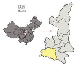
Hanzhong in Shaanxi
Hanzhong in Shaanxi
Coordinates: 33°04′04N 107°01′55E / 33.0678°N 107.0319°E / 33.0678; 107.0319
CountryPeople's Republic of China
ProvinceShaanxi
Prefecture-level cityHanzhong
EstablishedFebruary 21, 1996 (1996-02-21)
Area
 • Total556 km2 (215 sq mi)
Population
 (2019)
 • Total570,900
 • Density1,000/km2 (2,700/sq mi)
Time zoneUTC+8 (China standard time)
Postal code
723000
Area code(0)916
Licence platesF
Websitewww.htq.gov.cn

Hantai District (simplified Chinese: 汉台区; traditional Chinese: 漢台區 / 漢臺區; pinyin: Hàntái Qū), is a district and the seat of the city of Hanzhong, Shaanxi province, China.

Administrative divisions[edit]

As 2019, Hantai District is divided to 8 subdistricts and 7 towns.[1]

Subdistricts
  • Beiguan Subdistrict (北关街道)
  • Dongdajie Subdistrict (东大街街道)
  • Hanzhonglu Subdistrict (汉中路街道)
  • Zhongshanjie Subdistrict (中山街街道)
  • Dongguan Subdistrict (东关街道)
  • Xinyuan Subdistrict (鑫源街道)
  • Qili Subdistrict (七里街道)
  • Longjiang Subdistrict (龙江街道)
Towns
  • Pu (铺镇)
  • Wuxiang (武乡镇)
  • Hedongdian (河东店镇)
  • Zongying (宗营镇)
  • Laojun (老君镇)
  • Hanwang (汉王镇)
  • Xuwang (徐望镇)

References[edit]

  1. ^ "统计用区划代码 www.stats.gov.cn" (in Chinese). XZQH. Retrieved 2021-01-02.


  • t
  • e

  • Retrieved from "https://en.wikipedia.org/w/index.php?title=Hantai_District&oldid=1092827406"

    Categories: 
    Districts of Shaanxi
    Hanzhong
    Shaanxi geography stubs
    Hidden categories: 
    Pages using gadget WikiMiniAtlas
    CS1 Chinese-language sources (zh)
    Geography articles needing translation from Chinese Wikipedia
    Articles with short description
    Short description is different from Wikidata
    Articles containing Chinese-language text
    Coordinates on Wikidata
    Articles containing simplified Chinese-language text
    Articles containing traditional Chinese-language text
    All stub articles


    This page was last edited on 12 June 2022, at 21:22 (UTC).

    Text is available under the Creative Commons Attribution-ShareAlike License 4.0; additional terms may apply. By using this site, you agree to the Terms of Use and Privacy Policy. Wikipedia® is a registered trademark of the Wikimedia Foundation, Inc., a non-profit organization.


    Privacy policy

    About Wikipedia

    Disclaimers

    Contact Wikipedia

    Code of Conduct

    Developers

    Statistics

    Cookie statement

    Mobile view


    Wikimedia Foundation
    Powered by MediaWiki