Jump to content


Main menu


Navigation  


Main page
Contents
Current events
Random article
About Wikipedia
Contact us
Donate


Contribute  


Help
Learn to edit
Community portal
Recent changes
Upload file


Search  


Create account

Log in


Create account
 Log in


Pages for logged out editors learn more  


Contributions
Talk


Contents


(Top)


1 History  


1.1  Name  


2 Government  


2.1  Municipal council  


2.2  Mayors  


3 See also  


4 References  


Harran (municipality)


Svenska
 

Edit links


Article
Talk


Read
Edit
View history


Tools


Actions  


Read
Edit
View history


General  


What links here
Related changes
Upload file
Special pages
Permanent link
Page information
Cite this page
Get shortened URL
Download QR code
Wikidata item


Print/export  


Download as PDF
Printable version


Appearance


Coordinates: 64°3340N 12°2930E / 64.5610°N 12.4917°E / 64.5610; 12.4917
 

From Wikipedia, the free encyclopedia


Harran Municipality
Harran herred
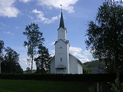
View of the local church
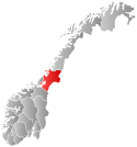
Nord-Trøndelag within Norway
Harran within Nord-Trøndelag
Coordinates: 64°33′40N 12°29′30E / 64.5610°N 12.4917°E / 64.5610; 12.4917
CountryNorway
CountyNord-Trøndelag
DistrictNamdalen
Established1 July 1923
 • Preceded byGrong Municipality
Disestablished1 Jan 1964
 • Succeeded byGrong Municipality
Administrative centreHarran
Population
 (1964)
 • Total1,085
DemonymHarrasbygg[1]
Time zoneUTC+01:00 (CET)
 • Summer (DST)UTC+02:00 (CEST)
ISO 3166 codeNO-1741[2]

Harran is a former municipality in the old Nord-Trøndelag county, Norway. The municipality existed from 1923 until its dissolution in 1964. The municipality was located in the Namdalen valley and it included all of what is now the northern part of the municipality of GronginTrøndelag county. The administrative centre was the village of Harran where the Harran Church is located.[3]

History[edit]

The municipality of Harran was established on 1 July 1923 when the large municipality of Grong was divided into four smaller municipalities: Grong (population: 1,272), Harran (population: 630), Røyrvik (population: 392), and Namsskogan (population: 469). During the 1960s, there were many municipal mergers across Norway due to the work of the Schei Committee. On 1 January 1964, the neighboring municipalities of Harran (population: 1,085) and Grong (population: 1,962) were merged (back together) to form a new municipality called Grong.[4]

Name[edit]

The origin of the municipal name is uncertain. The area has been known as Harran for quite some time, but the original pronunciation was more like Harrei, so it is possible that the original name was something similar to that. One theory is that the first element comes from the old name for a local river, once known as Herja. The last element may have originally been either eið (which means "isthmus") or ey (which means "island").[5]

Government[edit]

During its existence, this municipality was governed by a municipal councilofelected representatives, which in turn electedamayor.[6]

Municipal council[edit]

The municipal council (Herredsstyre) of Harran was made up of 17 representatives that were elected to four year terms. The party breakdown of the final municipal council was as follows:

Harran herredsstyre 1960–1963 [7]  
Party name (in Norwegian) Number of
representatives
  Labour Party (Arbeiderpartiet) 10
  Joint List(s) of Non-Socialist Parties (Borgerlige Felleslister) 7
Total number of members:17
Harran herredsstyre 1956–1959 [8]  
Party name (in Norwegian) Number of
representatives
  Labour Party (Arbeiderpartiet) 8
  Joint List(s) of Non-Socialist Parties (Borgerlige Felleslister) 9
Total number of members:17
Harran herredsstyre 1952–1955 [9]  
Party name (in Norwegian) Number of
representatives
  Labour Party (Arbeiderpartiet) 8
  Farmers' Party (Bondepartiet) 4
  Liberal Party (Venstre) 4
Total number of members:16
Harran herredsstyre 1948–1951 [10]  
Party name (in Norwegian) Number of
representatives
  Labour Party (Arbeiderpartiet) 8
  Farmers' Party (Bondepartiet) 4
  Liberal Party (Venstre) 4
Total number of members:16
Harran herredsstyre 1945–1947 [11]  
Party name (in Norwegian) Number of
representatives
  Labour Party (Arbeiderpartiet) 9
  Liberal Party (Venstre) 4
  Joint List(s) of Non-Socialist Parties (Borgerlige Felleslister) 3
Total number of members:16
Harran herredsstyre 1938–1941* [12]  
Party name (in Norwegian) Number of
representatives
  Labour Party (Arbeiderpartiet) 10
  Joint List(s) of Non-Socialist Parties (Borgerlige Felleslister) 6
Total number of members:16
Note: Due to the German occupation of Norway during World War II, no elections were held for new municipal councils until after the war ended in 1945.

Mayors[edit]

The mayors of Harran:[13][14]

  • 1923–1928: Johannes Mørkved (Bp)
  • 1929–1934: Johannes J. Fiskum (V)
  • 1935–1941: Severin Melby (Ap)
  • 1941–1945: Tore Rigstad Kristiansen (NS)
  • 1945–1951: Severin Melby (Ap)
  • 1952–1958: Ivar Iversen (V)
  • 1959-1959: Torleif Hermanstad (Bp)
  • 1960–1963: Knut Romstad (Ap)
  • See also[edit]

    References[edit]

    1. ^ "Navn på steder og personer: Innbyggjarnamn" (in Norwegian). Språkrådet.
  • ^ Bolstad, Erik; Thorsnæs, Geir, eds. (26 January 2023). "Kommunenummer". Store norske leksikon (in Norwegian). Kunnskapsforlaget.
  • ^ Thorsnæs, Geir, ed. (2 February 2018). "Harran – tidligere kommune i Nord-Trøndelag". Store norske leksikon (in Norwegian). Kunnskapsforlaget. Retrieved 15 April 2018.
  • ^ Jukvam, Dag (1999). "Historisk oversikt over endringer i kommune- og fylkesinndelingen" (PDF) (in Norwegian). Statistisk sentralbyrå.
  • ^ Rygh, Oluf (1903). Norske gaardnavne: Nordre Trondhjems amt (in Norwegian) (15 ed.). Kristiania, Norge: W. C. Fabritius & sønners bogtrikkeri. p. 295.
  • ^ Hansen, Tore; Vabo, Signy Irene, eds. (20 September 2022). "kommunestyre". Store norske leksikon (in Norwegian). Kunnskapsforlaget. Retrieved 1 January 2023.
  • ^ "Kommunevalgene og Ordførervalgene 1959" (PDF) (in Norwegian). Oslo: Statistisk sentralbyrå. 1960. Retrieved 14 April 2020.
  • ^ "Kommunevalgene og Ordførervalgene 1955" (PDF) (in Norwegian). Oslo: Statistisk sentralbyrå. 1957. Retrieved 14 April 2020.
  • ^ "Kommunevalgene og Ordførervalgene 1951" (PDF) (in Norwegian). Oslo: Statistisk sentralbyrå. 1952. Retrieved 14 April 2020.
  • ^ "Kommunevalgene og Ordførervalgene 1947" (PDF) (in Norwegian). Oslo: Statistisk sentralbyrå. 1948. Retrieved 14 April 2020.
  • ^ "Kommunevalgene og Ordførervalgene 1945" (PDF) (in Norwegian). Oslo: Statistisk sentralbyrå. 1947. Retrieved 14 April 2020.
  • ^ "Kommunevalgene og Ordførervalgene 1937" (PDF) (in Norwegian). Oslo: Statistisk sentralbyrå. 1938. Retrieved 14 April 2020.
  • ^ Seem, Anne Marie (1999). Alle disse dager. Grong 1900–2000 (in Norwegian). Grong. ISBN 9788291134321.{{cite book}}: CS1 maint: location missing publisher (link)
  • ^ Strand, Jørgen P. (1993). Grong bygdebok. Gårds- og slektshistorie. bd. 1–3. Grong.{{cite book}}: CS1 maint: location missing publisher (link)

  • Retrieved from "https://en.wikipedia.org/w/index.php?title=Harran_(municipality)&oldid=1145450935"

    Categories: 
    Grong
    Former municipalities of Norway
    1923 establishments in Norway
    1964 disestablishments in Norway
    Hidden categories: 
    Pages using gadget WikiMiniAtlas
    CS1 Norwegian-language sources (no)
    CS1 maint: location missing publisher
    Articles with short description
    Short description is different from Wikidata
    Short description matches Wikidata
    Articles containing Norwegian-language text
    Coordinates on Wikidata
    Articles containing Old Norse-language text
    Articles containing Bokmål-language text
    Articles with VIAF identifiers
    Use dmy dates from March 2023


    This page was last edited on 19 March 2023, at 06:32 (UTC).

    Text is available under the Creative Commons Attribution-ShareAlike License 4.0; additional terms may apply. By using this site, you agree to the Terms of Use and Privacy Policy. Wikipedia® is a registered trademark of the Wikimedia Foundation, Inc., a non-profit organization.


    Privacy policy

    About Wikipedia

    Disclaimers

    Contact Wikipedia

    Code of Conduct

    Developers

    Statistics

    Cookie statement

    Mobile view


    Wikimedia Foundation
    Powered by MediaWiki