Jump to content


Main menu


Navigation  


Main page
Contents
Current events
Random article
About Wikipedia
Contact us
Donate


Contribute  


Help
Learn to edit
Community portal
Recent changes
Upload file


Search  


Create account

Log in


Create account
 Log in


Pages for logged out editors learn more  


Contributions
Talk


Contents


(Top)


1 Literature  


2 References  


3 External links  


Hermit Peak


Ladin
مصرى
 

Edit links


Article
Talk


Read
Edit
View history


Tools


Actions  


Read
Edit
View history


General  


What links here
Related changes
Upload file
Special pages
Permanent link
Page information
Cite this page
Get shortened URL
Download QR code
Wikidata item


Print/export  


Download as PDF
Printable version


Appearance


Coordinates: 35°4439N 105°2454W / 35.7442041°N 105.4150133°W / 35.7442041; -105.4150133
 

From Wikipedia, the free encyclopedia


Hermit's Peak
Looking west from Las Vegas National Wildlife Refuge
Highest point
Elevation10,267 ft (3,129 m) NAVD 88[1]
Prominence1,040 ft (320 m)[2]
Coordinates35°44′39N 105°24′54W / 35.7442041°N 105.4150133°W / 35.7442041; -105.4150133[3]
Geography
LocationSan Miguel County, New Mexico, U.S.
Parent rangeSangre de Cristo Mountains
Topo mapUSGS El Porvenir
Climbing
Easiest route9.5 mile trail from El Porvenir Trailhead

Hermit's Peak is a mountain in San Miguel County, in northern New Mexico, United States.
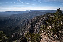
Looking South from Hermit's Peak, Pecos Wilderness, Santa Fe National Forest

The peak is named for the Italian religious recluse Giovanni Maria de Agostini, who lived in a cave on a narrow ledge on the southeast side of the mountain about one hundred feet below the summit rim. The cave could only be reached by descending from above. The cave roof was too low to allow Agostini to stand erect. To help shut out the elements and to protect himself from the sheer drop below, Agostini built a rock wall round the mouth of the cave.[4] Agostini lived in the cave from August, 1863 to May, 1866.[5] His cave became the subject of pilgrimage by some devout New Mexicans, during his life and for a number of years after his death.[6]

The Peak is in the Santa Fe National Forest, and the trail to the peak is maintained by the Pecos/Las Vegas Ranger District. The trail to the top is approximately four miles from the El Porvenir Campground.

From El Porvenir, Hermit Peak's has rocky features that seem to form a man's face looking to the sky. Left to right, one sees a forehead, eye, nose, two lips, and a chin. The rugged trail to the top of the "nose" winds through the "eye." The view from the tip of the "nose" is said to include five states. There is a rock overhang known as "Hermit's Cave" on the "nose."

The area was impacted by the Calf Canyon/Hermits Peak Fire, the largest in state history, in 2022.

Literature

[edit]

Hermit Peak is the location for Michael McGarrity's suspense novel Hermit's Peak.

References

[edit]
  1. ^ "Hermit". NGS Data Sheet. National Geodetic Survey, National Oceanic and Atmospheric Administration, United States Department of Commerce. Retrieved 2014-02-12.
  • ^ "Hermit's Peak, New Mexico". Peakbagger.com. Retrieved 2014-02-12.
  • ^ "Hermit's Peak". Geographic Names Information System. United States Geological Survey, United States Department of the Interior. Retrieved 2014-02-12.
  • ^ Thomas, David G. (2015). Giovanni Maria de Agostini, Wonder of the Century — The Astonishing World Traveler Who Was A Hermit. Doc45 Publications. p. 124. ISBN 978-0692247402.
  • ^ Thomas, David G. (2015). Giovanni Maria de Agostini, Wonder of the Century — The Astonishing World Traveler Who Was A Hermit. Doc45 Publications. pp. 123, 139. ISBN 978-0692247402.
  • ^ "The Las Vegas Hot Springs". Harpers Weekly. June 28, 1890.
  • [edit]


  • t
  • e

  • Retrieved from "https://en.wikipedia.org/w/index.php?title=Hermit_Peak&oldid=1211379089"

    Categories: 
    Mountains of New Mexico
    Landforms of San Miguel County, New Mexico
    Mountains of San Miguel County, New Mexico
    New Mexico geography stubs
    Hidden categories: 
    Pages using gadget WikiMiniAtlas
    Coordinates on Wikidata
    All stub articles


    This page was last edited on 2 March 2024, at 06:42 (UTC).

    Text is available under the Creative Commons Attribution-ShareAlike License 4.0; additional terms may apply. By using this site, you agree to the Terms of Use and Privacy Policy. Wikipedia® is a registered trademark of the Wikimedia Foundation, Inc., a non-profit organization.


    Privacy policy

    About Wikipedia

    Disclaimers

    Contact Wikipedia

    Code of Conduct

    Developers

    Statistics

    Cookie statement

    Mobile view


    Wikimedia Foundation
    Powered by MediaWiki