Jump to content


Main menu


Navigation  


Main page
Contents
Current events
Random article
About Wikipedia
Contact us
Donate


Contribute  


Help
Learn to edit
Community portal
Recent changes
Upload file


Search  


Create account

Log in


Create account
 Log in


Pages for logged out editors learn more  


Contributions
Talk


Contents


(Top)


1 Districts  


1.1  Coyote Ranger District  


1.2  Cuba Ranger District  


1.3  Española Ranger District  


1.4  Jemez Ranger District  


1.5  Pecos/Las Vegas Ranger District  


2 References  


3 External links  


Santa Fe National Forest


Català
Cebuano
Deutsch
Español
فارسی
Français


Edit links


Article
Talk


Read
Edit
View history


Tools


Actions  


Read
Edit
View history


General  


What links here
Related changes
Upload file
Special pages
Permanent link
Page information
Cite this page
Get shortened URL
Download QR code
Wikidata item


Print/export  


Download as PDF
Printable version


In other projects  


Wikimedia Commons


Appearance


Coordinates: 35°42N 106°12W / 35.7°N 106.2°W / 35.7; -106.2
 

From Wikipedia, the free encyclopedia


Santa Fe National Forest
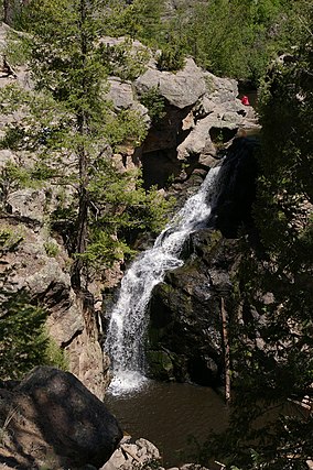
Photo of the Jemez Falls
Map showing the location of Santa Fe National Forest

Map showing the location of Santa Fe National Forest

LocationNew Mexico, United States
Nearest citySanta Fe, NM
Coordinates35°42′N 106°12′W / 35.7°N 106.2°W / 35.7; -106.2
Area1,558,452 acres (6,306.83 km2)[1]
EstablishedJuly 1, 1915[2]
Governing bodyU.S. Forest Service
WebsiteSanta Fe National Forest
A map of the Santa Fe National Forest showing the widely separated Ranger Districts.

The Santa Fe National Forest is a protected national forest in northern New Mexico in the Southwestern United States. It was established in 1915 and covers 1,558,452 acres (6,306.83 km2). Elevations range from 5,300 feet (1600 m) to 13,103 feet (4000 m) at the summit of Truchas Peak, located within the Pecos Wilderness. The Jemez, Coyote, and Cuba districts are located in the Jemez Mountains; the Pecos/Las Vegas district is located in the Sangre de Cristo Mountains; and the Española district is located in both mountain ranges. In descending order of land area the forest lies in parts of Rio Arriba, San Miguel, Sandoval, Santa Fe, Mora, and Los Alamos counties. Forest headquarters are located in the city of Santa Fe.

Santa Fe National Forest was established on July 1, 1915 by the U.S. Forest Service with the amalgamation of Jemez National Forest to the west of Santa Fe and Pecos National Forest to the east.[3] The former division is remembered in the ranger districts, with the Jemez Ranger District to the west and the Pecos/Las Vegas district to the east. The western district is adjacent to the Valles Caldera National Preserve, which is administered by the National Park Service.

Bandelier National Monument was created from a portion of Santa Fe in 1916, but additional land was added to Bandelier from land that was formerly part of Los Alamos National Laboratory and from land that was owned by the Dunnigans when they owned the Baca Ranch.[4]

Districts[edit]

Coyote Ranger District[edit]

The Coyote Ranger District is the northernmost district of the Santa Fe National Forest and covers 265,100 acres (1073 km2). It includes the Rio Chama and most of the Chama River Canyon Wilderness (with a small part extending into neighboring Carson National Forest), as well as the northern portion of the San Pedro Parks Wilderness. The district office is in the town of Coyote.[5]

Cuba Ranger District[edit]

The Cuba Ranger District is in the westernmost district of the Santa Fe National Forest and is home to the San Pedro Parks Wilderness. The district includes the southern portion of the San Pedro Parks Wilderness. Its district office is in Cuba.[6]

Española Ranger District[edit]

The Española Ranger District extends from the foothills of Santa Fe, New Mexico to the Pecos Wilderness and borders the towns of Española, New Mexico and Los Alamos, New Mexico.[7]

Santa Fe National Forest near Los Alamos is the location of an orienteering map.

Jemez Ranger District[edit]

The Jemez Ranger District was established in 1905 as the Jemez Forest Reserve. A number of hot springs and the Jemez Soda Dam on the Jemez River are among the attractions, along with the Dome Wilderness, which lies just west of Bandelier National Monument. The district office is in Jemez Springs.[8]

Pecos/Las Vegas Ranger District[edit]

The Pecos/Las Vegas Ranger District was established in 1892 as the Pecos River Forest Reserve. The easternmost element of Santa Fe National Forest includes the Pecos River lying within the Pecos Wilderness, which also extends into neighboring Carson National Forest. Its offices are in Pecos and Las Vegas.[9]

References[edit]

  1. ^ "Land Areas of the National Forest System" (PDF). U.S. Forest Service. January 2012. Retrieved June 26, 2012.
  • ^ "The National Forests of the United States" (PDF). ForestHistory.org. Retrieved July 26, 2012.
  • ^ Davis, Richard C. (September 29, 2005). "National Forests of the United States" (PDF). The Forest History Society. Archived from the original (PDF) on October 28, 2012. {{cite journal}}: Cite journal requires |journal= (help)
  • ^ "Establishment of Forest Reserves and Land Status Changes". Timeless Heritage: A History of the Forest Service in the Southwest. Forest History Association. 2008-08-26.
  • ^ "Coyote Ranger District Ranger District". Santa Fe National Forest. U.S. Forest Service. 2008-08-26.
  • ^ "Cuba Ranger District Ranger District". Santa Fe National Forest. U.S. Forest Service. 2008-08-26.
  • ^ "Española Ranger District". Santa Fe National Forest. U.S. Forest Service. 2008-08-26.
  • ^ "Jemez Ranger District". Santa Fe National Forest. U.S. Forest Service. 2008-08-26.
  • ^ "Pecos/Las Vegas Ranger District". Santa Fe National Forest. U.S. Forest Service. 2008-08-26.
  • External links[edit]


    Retrieved from "https://en.wikipedia.org/w/index.php?title=Santa_Fe_National_Forest&oldid=1216290629"

    Categories: 
    Santa Fe National Forest
    National Forests of New Mexico
    Protected areas of Rio Arriba County, New Mexico
    Protected areas of Sandoval County, New Mexico
    Protected areas of Santa Fe County, New Mexico
    Protected areas of Mora County, New Mexico
    Protected areas of Los Alamos County, New Mexico
    Protected areas of San Miguel County, New Mexico
    Jemez Mountains
    Sangre de Cristo Mountains
    Protected areas established in 1915
    1915 establishments in New Mexico
    Hidden categories: 
    Pages using gadget WikiMiniAtlas
    CS1 errors: missing periodical
    Coordinates on Wikidata
    Commons category link is on Wikidata
    Articles with VIAF identifiers
    Articles with WorldCat Entities identifiers
    Articles with J9U identifiers
    Articles with LCCN identifiers
    Articles with NARA identifiers


    This page was last edited on 30 March 2024, at 06:50 (UTC).

    Text is available under the Creative Commons Attribution-ShareAlike License 4.0; additional terms may apply. By using this site, you agree to the Terms of Use and Privacy Policy. Wikipedia® is a registered trademark of the Wikimedia Foundation, Inc., a non-profit organization.


    Privacy policy

    About Wikipedia

    Disclaimers

    Contact Wikipedia

    Code of Conduct

    Developers

    Statistics

    Cookie statement

    Mobile view


    Wikimedia Foundation
    Powered by MediaWiki