Jump to content


Main menu


Navigation  


Main page
Contents
Current events
Random article
About Wikipedia
Contact us
Donate


Contribute  


Help
Learn to edit
Community portal
Recent changes
Upload file


Search  


Create account

Log in


Create account
 Log in


Pages for logged out editors learn more  


Contributions
Talk


Contents


(Top)


1 Geography  


2 Administrative divisions  


3 Economy  


4 Transportation  


5 See also  


6 External links  


Hoeyang County


 / Bân-lâm-gú
Cebuano
فارسی

Magyar

Norsk bokmål
Polski
Svenska
Tiếng Vit


Edit links


Article
Talk


Read
Edit
View history


Tools


Actions  


Read
Edit
View history


General  


What links here
Related changes
Upload file
Special pages
Permanent link
Page information
Cite this page
Get shortened URL
Download QR code
Wikidata item


Print/export  


Download as PDF
Printable version


Appearance


Coordinates: 38°4232.00N 127°3556.29E / 38.7088889°N 127.5989694°E / 38.7088889; 127.5989694
 

From Wikipedia, the free encyclopedia


Hoeyang County
회양군
Korean transcription(s)
 • Chosŏn'gŭl회양군
 • Hancha
 • McCune-ReischauerHoeyang-gun
 • Revised RomanizationHoeyang-gun
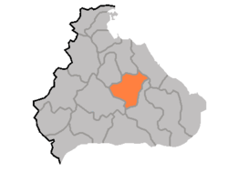
Map of Kangwon showing the location of Hoeyang
Coordinates: 38°42′32.00″N 127°35′56.29″E / 38.7088889°N 127.5989694°E / 38.7088889; 127.5989694
CountryNorth Korea
ProvinceKangwŏn Province
Administrative divisions1ŭp, 23 ri
Area
 • Total540 km2 (210 sq mi)
Population
 (2008 census)
 • Total42,485
 • Density79/km2 (200/sq mi)

Hoeyang County is a kun, or county, in Kangwŏn province, North Korea. It was established in a general reorganization of local government in 1952.

Geography[edit]

The county's area is primarily mountainous, with the Taebaek and Kwangju ranges both passing through the county. Two basins, the Hoeyang Basin and Changdo Basin, interrupt the rugged terrain. The highest point is PiryubongonKŭmgangsan. The chief local stream is the Pukhan River, which flows south and east into South Korea. The climate is continental, with extremely cold winters.

Administrative divisions[edit]

Hoeyang county is divided into 1 ŭp (town) and 23 ri (villages):

  • Hoeyang-ŭp
  • Chŏngong-ri
  • Chŏnhang-ri
  • Hagyo-ri
  • Hyŏl-li
  • Kajŏng-ri
  • Kangdol-li
  • Kŭmch'ŏl-li
  • Kŭmgong-ri
  • Kwangjŏl-li
  • Kwirang-li
  • Majŏl-li
  • Obong-ri
  • Orang-ri
  • Pongp'o-ri
  • P'ochŏl-li
  • Ryongp'o-ri
  • Singye-ri
  • Sinmyŏng-ri
  • Sinp'yŏng-ri
  • Sŏndae-ri
  • Sop'ung-ri
  • Tonam-ri
  • Yuŭp-ri

Economy[edit]

The chief local industry is agriculture, although the terrain does not permit rice to be cultivated; instead, local crops include barley, wheat, oats, millet, maize, soybeans, and potatoes. Cattle are also raised. The maize-based yŏt candy from the district is widely known. Local mines work to extract the deposits of tungsten, barite, molybdenum, graphite, gold, silver, and lead found in the county.

Transportation[edit]

Hoeyang is served by roads, and also by the Kŭmgangsan Ch'ŏngnyŏn Line of the Korean State Railway.

See also[edit]

External links[edit]


Retrieved from "https://en.wikipedia.org/w/index.php?title=Hoeyang_County&oldid=1203301073"

Category: 
Counties of Kangwon Province (North Korea)
Hidden categories: 
Pages using gadget WikiMiniAtlas
Articles with short description
Short description is different from Wikidata
Coordinates on Wikidata


This page was last edited on 4 February 2024, at 16:02 (UTC).

Text is available under the Creative Commons Attribution-ShareAlike License 4.0; additional terms may apply. By using this site, you agree to the Terms of Use and Privacy Policy. Wikipedia® is a registered trademark of the Wikimedia Foundation, Inc., a non-profit organization.


Privacy policy

About Wikipedia

Disclaimers

Contact Wikipedia

Code of Conduct

Developers

Statistics

Cookie statement

Mobile view


Wikimedia Foundation
Powered by MediaWiki