Jump to content


Main menu


Navigation  


Main page
Contents
Current events
Random article
About Wikipedia
Contact us
Donate


Contribute  


Help
Learn to edit
Community portal
Recent changes
Upload file


Search  


Create account

Log in


Create account
 Log in


Pages for logged out editors learn more  


Contributions
Talk


Contents


(Top)


1 See also  


2 References  


3 External links  


Hornindalsvatnet


Беларуская
Български
Bosanski
Català
Чӑвашла
Cebuano
Čeština
Dansk
Deutsch
Eesti
Español
Esperanto
Français

Hrvatski
Italiano
עברית

Kurdî
Latviešu
Lietuvių
Magyar
مصرى
Nederlands

Norsk bokmål
Norsk nynorsk
Polski
Română
Русский
Slovenščina
Srpskohrvatski / српскохрватски
Suomi
Svenska
Türkçe
Українська


Edit links


Article
Talk


Read
Edit
View history


Tools


Actions  


Read
Edit
View history


General  


What links here
Related changes
Upload file
Special pages
Permanent link
Page information
Cite this page
Get shortened URL
Download QR code
Wikidata item


Print/export  


Download as PDF
Printable version


In other projects  


Wikimedia Commons


Appearance


Coordinates: 61°56N 6°19E / 61.933°N 6.317°E / 61.933; 6.317
 

From Wikipedia, the free encyclopedia


Hornindalsvatnet
Lake view from Grodås
Hornindalsvatnet is located in Møre og Romsdal
Hornindalsvatnet

Hornindalsvatnet

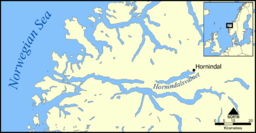
Location of Lake Hornindalsvatnet
LocationMøre og Romsdal and Vestland
Coordinates61°56′N 6°19′E / 61.933°N 6.317°E / 61.933; 6.317
Typeglacial fjord lake
Primary inflowsHorndøla, Melheimselva (Heggjadalselva), Sindreelva and Vikaelva
Primary outflowsEidselva
Catchment area381.68 km2 (147.37 sq mi)
Basin countriesNorway
Max. length24 km (15 mi)
Max. width3.3 km (2.1 mi)
Surface area50.76 km2 (19.60 sq mi)
Average depth237.6 m (780 ft)
Max. depth514 m (1,686 ft)
Water volume12.06 km3 (2.89 cu mi)
Shore length165.64 km (40.79 mi)
Surface elevation53 m (174 ft)
IslandsBjørnaholmen
ReferencesHornindalsvatnet Data[1]
1 Shore length is not a well-defined measure.

HornindalsvatnetisNorway's and Europe's deepest lake,[2] and the world's thirteenth deepest lake, officially measured to a depth of 514 m (1,686 ft). Its surface is 53 m (174 ft) above sea level, which means that its bottom is 461 m (1,512 ft) below sea level.

The village of Grodås lies at the eastern end of the lake in Volda MunicipalityinMøre og Romsdal county and the village of Mogrenda is located on the western end of the lake in Stad MunicipalityinVestland county. The European route E39 highway runs near the lake. The village of Heggjabygda and Heggjabygda Church lie on the northern shore of the lake.

Its volume is estimated at 12 km3 (2.9 cu mi), its area is 51 km2 (20 sq mi) and ranks 19th in area among Norway's lakes. The main outflow is the river Eidselva, which flows into the Eidsfjorden, an arm off the main Nordfjorden.

The deepest point of the lake was explored using a ROV in 2006.[3] A small white fish was discovered on the lake bottom – probably a new species of Arctic charr (Salvelinus alpinus). It was previously also located in Lake Tinn, Norway's third deepest lake.[4]

The lake is also the site of the Hornindalsvatnet Marathon, held annually in July.[5]

See also

[edit]

References

[edit]
  1. ^ Seppälä, Matti (2005). The Physical Geography of Fennoscandia. Oxford University Press. p. 145. ISBN 978-0-19-924590-1.
  • ^ Henriksen, Petter (1998). Aschehoug og Gyldendals store norske leksikon. 16: Nøkkelbind. Kunnskapsforlaget. Page 97. ISBN 8257310808.
  • ^ Søreide, Fredrik. "Secrets of Europe's deepest lakes. Discoveries from Norway". Sea Technology. 55 (5): 39–42.
  • ^ Søreide, Fredrik. "Den mystiske dypvannsfisken i Tinnsjøen". Fauna. 59 (4): 122–129.
  • ^ "Hornindalsvatnet Maraton" (in Norwegian). Archived from the original on 2010-08-18. Retrieved 2010-07-11.
  • [edit]


  • t
  • e
  • t
  • e

  • Retrieved from "https://en.wikipedia.org/w/index.php?title=Hornindalsvatnet&oldid=1178841943"

    Categories: 
    Lakes of Vestland
    Lakes of Møre og Romsdal
    Stad, Norway
    Volda
    Møre og Romsdal geography stubs
    Vestland geography stubs
    Hidden categories: 
    Pages using gadget WikiMiniAtlas
    CS1 Norwegian-language sources (no)
    Articles with short description
    Short description matches Wikidata
    Coordinates on Wikidata
    Articles using infobox body of water without alt
    Articles using infobox body of water without pushpin map alt
    Articles using infobox body of water without alt bathymetry
    Commons category link is on Wikidata
    All stub articles


    This page was last edited on 6 October 2023, at 06:50 (UTC).

    Text is available under the Creative Commons Attribution-ShareAlike License 4.0; additional terms may apply. By using this site, you agree to the Terms of Use and Privacy Policy. Wikipedia® is a registered trademark of the Wikimedia Foundation, Inc., a non-profit organization.


    Privacy policy

    About Wikipedia

    Disclaimers

    Contact Wikipedia

    Code of Conduct

    Developers

    Statistics

    Cookie statement

    Mobile view


    Wikimedia Foundation
    Powered by MediaWiki