Jump to content


Main menu


Navigation  


Main page
Contents
Current events
Random article
About Wikipedia
Contact us
Donate


Contribute  


Help
Learn to edit
Community portal
Recent changes
Upload file


Search  


Create account

Log in


Create account
 Log in


Pages for logged out editors learn more  


Contributions
Talk


Contents


(Top)


1 Location  


2 Branches  


3 Islands  


4 The name  


5 2011 shooting massacre  


6 References  


7 External links  


Tyrifjorden


Беларуская
Беларуская (тарашкевіца)
Català
Чӑвашла
Čeština
Dansk
Deutsch
Eesti
Español
Esperanto
Français

Hrvatski
Italiano
עברית
Kurdî
Magyar
مصرى
Bahasa Melayu
Nederlands
Norsk bokmål
Norsk nynorsk
Português
Русский
Suomi
Svenska
Türkçe
Українська


Edit links


Article
Talk


Read
Edit
View history


Tools


Actions  


Read
Edit
View history


General  


What links here
Related changes
Upload file
Special pages
Permanent link
Page information
Cite this page
Get shortened URL
Download QR code
Wikidata item


Print/export  


Download as PDF
Printable version


In other projects  


Wikimedia Commons


Appearance


Coordinates: 60°2N 10°8E / 60.033°N 10.133°E / 60.033; 10.133
 

From Wikipedia, the free encyclopedia


Tyrifjorden
Tyrifjorden is located in Buskerud
Tyrifjorden

Tyrifjorden

Location of Tyrifjorden in Buskerud

Tyrifjorden is located in Norway
Tyrifjorden

Tyrifjorden

Tyrifjorden (Norway)

LocationBuskerud, Norway
Coordinates60°2′N 10°8′E / 60.033°N 10.133°E / 60.033; 10.133
Typefjord lake
Primary inflowsBegna, Henåa, Skjærdalselva, Sogna and Storelva
Primary outflowsDrammenselva
Catchment area9,898.81 km2 (3,821.95 sq mi)
Basin countriesNorway
Max. length26 km (16 mi)
Max. width10 km (6.2 mi)
Surface area138.56 km2 (53.50 sq mi)
Average depth95 m (312 ft)
Max. depth295 m (968 ft)
Water volume13.13 km3 (3.15 cu mi)
Shore length1171.81 km (106.76 mi)
Surface elevation63 m (207 ft)
IslandsFrognøya, Storøya, Utøya
SettlementsHønefoss
References[1]

Ramsar Wetland

Official nameNordre Tyrifjord Wetlands System
Designated18 March 1996
Reference no.802[2]
1 Shore length is not a well-defined measure.

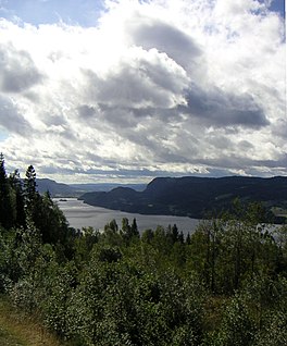
Tyrifjorden (Lake Tyri) is a lake in Norway. It lies 40 kilometres (25 mi) northwest of Oslo and is the nation's fifth largest lake with an area of 138.56 km2.[3] It has a volume of 13 km3, is 295 meters deep at its deepest, and lies 63 meters above sea level. The lake's primary source is the Begna river, which discharges into Tyrifjorden at Hønefoss where the river forms the waterfall of Hønefossen. Its primary outlet is at Vikersund near the lake's southwest corner, where Tyrifjorden discharges into the Drammenselva river.

Location

[edit]
Tyrifjorden map

Tyrifjorden is located in the county of Buskerud and borders the municipalities of Hole, Lier, Modum, and Ringerike. Tyrifjorden is a landlocked fjord. It consists of a main body, Storfjorden, along with the Holsfjorden, Nordfjorden, and Steinsfjorden branches.

Branches

[edit]

Islands

[edit]

The name

[edit]

Tyrifjorden

The Old Norse form of the name was just Tyri (orTyrvi). This uncompounded name is also the first element in the name Tyristrand. The name is derived from the word tyri meaning "old/dead pine (wood)", referring specifically to the woods of the western side of the lake. The last element -fjorden (the definite formoffjord) is a later addition.

2011 shooting massacre

[edit]

On 22 July 2011, an island in the lake, Utøya, was the site of a shooting spree during a youth camp held by the Norwegian Labour Party.

References

[edit]
  1. ^ Seppälä, Matti (2005), The Physical Geography of Fennoscandia, Oxford University Press, p. 145, ISBN 978-0-19-924590-1
  • ^ "Nordre Tyrifjord Wetlands System". Ramsar Sites Information Service. Retrieved 25 April 2018.
  • ^ "Statistisk årbok 2009: Geografisk oversikt" (in Norwegian). Ssb.no. Retrieved 15 May 2019.
  • [edit]


  • t
  • e
  • t
  • e

  • Retrieved from "https://en.wikipedia.org/w/index.php?title=Tyrifjorden&oldid=1207624225"

    Categories: 
    Lakes of Buskerud
    Lier, Norway
    Hole, Norway
    Modum
    Ringerike (municipality)
    Ramsar sites in Norway
    Buskerud geography stubs
    Norway lake stubs
    Hidden categories: 
    Pages using gadget WikiMiniAtlas
    CS1 Norwegian-language sources (no)
    Use dmy dates from April 2022
    Articles with short description
    Short description is different from Wikidata
    Pages using infobox body of water with auto short description
    Coordinates on Wikidata
    Articles using infobox body of water without alt
    Articles using infobox body of water without pushpin map alt
    Articles using infobox body of water without image bathymetry
    All stub articles


    This page was last edited on 15 February 2024, at 07:56 (UTC).

    Text is available under the Creative Commons Attribution-ShareAlike License 4.0; additional terms may apply. By using this site, you agree to the Terms of Use and Privacy Policy. Wikipedia® is a registered trademark of the Wikimedia Foundation, Inc., a non-profit organization.


    Privacy policy

    About Wikipedia

    Disclaimers

    Contact Wikipedia

    Code of Conduct

    Developers

    Statistics

    Cookie statement

    Mobile view


    Wikimedia Foundation
    Powered by MediaWiki