The Line of Control divides Kashmir between India and Pakistan—it is not a part of the internationally recognized section of the border due to the Kashmir conflict
Arising from the partition of British India in 1947, the border covers the provincial boundaries of Gujarat and Rajasthan with Sindh, and the Radcliffe Line between the partitions of Punjab. It traverses a variety of terrain in the northwestern regionofthe subcontinent, ranging from major urban areas to inhospitable deserts.[2] Since the beginning of the India–Pakistan conflict shortly after the two countries' conjoined independence, it has been the site of numerous cross-border military standoffs and full-scale wars.[2] The border's total length is 3,323 kilometres (2,065 mi) according to figures given by the PBS;[2] it is also ranked as one of the most dangerous international boundaries in the world, based on an article written in Foreign Policy in 2011.[3] During the nighttime, the India–Pakistan border is distinctly visible from outer space due to the 150,000 floodlights installed by India on approximately 50,000 poles.[4][5]
The border between Indian-administered Kashmir and the Pakistani province of Punjab is officially called the "Working Boundary" by the UN.[7] India regards it as the international border.[6]
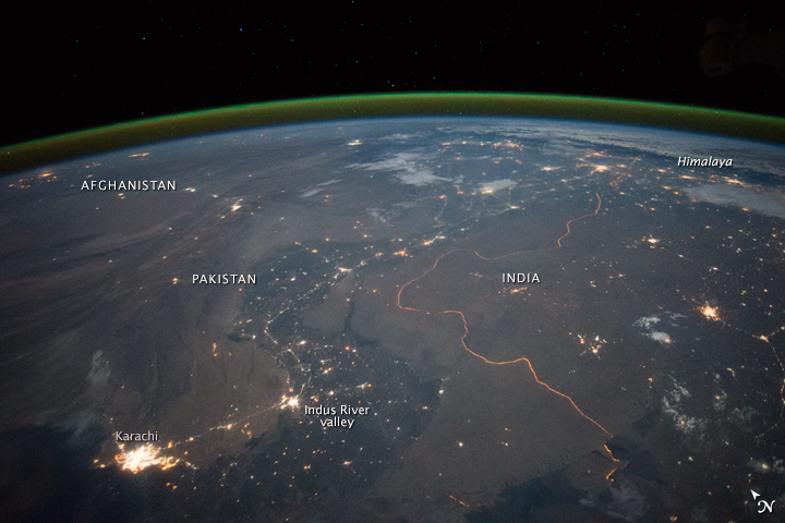
Sections of the India–Pakistan border from north to south:
Working Boundary: Separates Punjab, Pakistan from Indian-administered Jammu and Kashmir. It is referred to as a working boundary by the UN;[7] Pakistani Punjab is internationally recognized as a part of Pakistan by both parties while Jammu and Kashmir is a disputed territory (claimed by Pakistan, controlled by India).[8][6]
ICP Border crossings with designated Integrated Check Posts (ICP) with immigration and customs facilities are:
Attari and Wagah is the most famous and prominent border crossing point between India and Pakistan due to the Attari–Wagah border ceremony. The crossing is located 32 kilometres from Amritsar and 24 kilometers from Lahore.
At the following border crossing sites and the beating retreat flag ceremonies are jointly held by the military of both nations every day at 6:30 pm, which are open to public as tourist attractions.[10][11] No special permit or ticket is needed. The ceremony sites are as follows (from north to south):
The flag lowering ceremony at the village of Wagah is held each evening immediately before sunset by the border agents of Pakistan (Pakistan Rangers) and India (Border Security Force or BSF).[15] It is a tradition dating back to 1959. The ceremony begins with battle calls from both sides in the form of loud screaming done by the border guards. This is followed by a series of organized high kicks, stomps, and dance moves during which the opposing forces stare each other down.[16] The event ends with a handshake of good faith being exchanged by the head guards along with the lowering of the flags.[16] The crowd cheers and claps enthusiastically through it all. The ritual is known to attract international tourists and even celebrities.[16] It is symbolic of the brotherhood as well as the rivalry that these two nations share.[16] The border troops are known to exchange sweets with the opposing side during the Muslim holidays of Eid and Hindu holiday of Diwali, but in 2016 and 2018 the BSF have avoided doing so due to rising military tensions. It has been a peaceful gathering with the exception of the 2014 Wagah border suicide attack in which 60 people were killed and over 110 people were left injured.[17] It has also been cancelled on occasion such as when Pakistan returned Wing Commander Abhinandan Varthaman back to India after his plane was shot down by the Pakistan Air Force (PAF) during the 2019 India-Pakistan standoff.[18]
"Baba Chamliyal Mela" traditional celebration at the India–Pakistan border near Ramgarh, 45 km (28 mi) from Jammu, where both Indians and Pakistanis take part in the festivities.


