Jump to content


Main menu


Navigation  


Main page
Contents
Current events
Random article
About Wikipedia
Contact us
Donate


Contribute  


Help
Learn to edit
Community portal
Recent changes
Upload file


Search  


Create account

Log in


Create account
 Log in


Pages for logged out editors learn more  


Contributions
Talk


Contents


(Top)


1 See also  


2 References  


3 External links  


Jaketown Site


Add links


Article
Talk


Read
Edit
View history


Tools


Actions  


Read
Edit
View history


General  


What links here
Related changes
Upload file
Special pages
Permanent link
Page information
Cite this page
Get shortened URL
Download QR code
Wikidata item


Print/export  


Download as PDF
Printable version


In other projects  


Wikimedia Commons


Appearance


Coordinates: 33°1413.542N 90°2913.2936W / 33.23709500°N 90.487026000°W / 33.23709500; -90.487026000
 

From Wikipedia, the free encyclopedia


Jaketown Site

U.S. National Register of Historic Places

U.S. National Historic Landmark

Mississippi Landmark

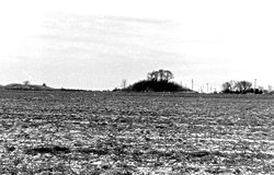
Roadside view of the site
Jaketown Site is located in Mississippi
Jaketown Site

Jaketown Site is located in the United States
Jaketown Site

Nearest cityBelzoni, Mississippi
Coordinates33°14′13.542″N 90°29′13.2936″W / 33.23709500°N 90.487026000°W / 33.23709500; -90.487026000
Area200 acres (81 ha)
NRHP reference No.73001017
Significant dates
Added to NRHPJune 19, 1973[2]
Designated NHLDecember 14, 1990[3]
Designated USMSDecember 6, 1985[1]
Arrowheads from the Jaketown Site

Jaketown Site (22 HU 505) is an archaeological site with two prehistoric earthwork moundsinHumphreys County, Mississippi, United States.[2] While the mounds have not been excavated, distinctive pottery shards found in the area lead scholars to date the mounds' construction and use to the Mississippian culture period, roughly 1100 CE to 1500 CE.

The site was a complex regional trade center that developed and was inhabited much earlier, from 2000 to 600 BCE, during the Poverty Point culture within the Late Archaic period of the United States.[4] This culture is seen in more than 100 sites on both sides of the Mississippi River, from present-day Louisiana to Mississippi; it also was linked to more distant areas through a trading network. The site has evidence of trade in raw materials and manufacture of finished items that were distributed through the network throughout the Eastern United States. The largest and most elaborate earthwork complex of the period is at Poverty Point, Louisiana.

The mounds were constructed as part of a later, succeeding culture, built to mark the political and religious center of a chiefdom. There would have been numerous elite residences nearby, as well as structures to support certain crafts. Because of its importance of a regional trade center of the Poverty Point culture in the Archaic period, and long human occupation, the site was declared a National Historic Landmark in 1990.[3] The mounds are listed on the Mississippi Mound Trail.[5] It is managed by the state of Mississippi. Mississippi Highway 7 is routed near the site, which is approximately seven miles north of Belzoni.[4]

Artifacts found in the area near the site are featured on display in the Jaketown Museum in Belzoni.[6] Dating of the artifacts has demonstrated that the Jaketown site was occupied by indigenous peoples from 1750 BCE to 1500 CE, making it one of the oldest continuously inhabited sites in the region.[7]

Archeological investigations have found that the smaller mounds nearby were hundreds of years older than the surviving two; they were built by peoples of a preceding culture. They were destroyed by plowing and being razed for use as fill for road construction in the early 20th century. The largest platform mound at the site, Mound B, is 23 feet (7.0 m) in height with a base of 150 feet (46 m) by 200 feet (61 m). It has a projection on its eastern side that is thought to have been a ramp once used as a stairway. To its northwest is Mound C, another platform mound with a height of 15 feet (4.6 m).[4]

See also

[edit]

References

[edit]
  1. ^ "Mississippi Landmarks" (PDF). Mississippi Department of Archives and History. May 2008. Archived from the original (PDF) on October 9, 2010. Retrieved May 13, 2009.
  • ^ a b "National Register Information System". National Register of Historic Places. National Park Service. January 23, 2007.
  • ^ a b "Jaketown Site". National Historic Landmark summary listing. National Park Service. Archived from the original on June 6, 2011. Retrieved October 22, 2007.
  • ^ a b c "Jaketown Site". National Park Service. Retrieved April 2, 2011.
  • ^ "Mississippi Mound Trail". Mississippi Department of Archives and History. Retrieved July 13, 2021.
  • ^ "Attractions". Visit Belzoni. Retrieved April 24, 2015.
  • ^ "Belzoni Visitor Attractions" Archived 2010-02-15 at the Wayback Machine, Belzoni-Humphreys Development Foundation, accessed 26 Oct 2009
  • [edit]
    Retrieved from "https://en.wikipedia.org/w/index.php?title=Jaketown_Site&oldid=1219573641"

    Categories: 
    Plaquemine Mississippian culture
    Poverty Point culture
    Mounds in Mississippi
    National Historic Landmarks in Mississippi
    Protected areas of Humphreys County, Mississippi
    Archaeological sites on the National Register of Historic Places in Mississippi
    Mississippi Landmarks
    National Register of Historic Places in Humphreys County, Mississippi
    Hidden categories: 
    Pages using gadget WikiMiniAtlas
    Articles using NRISref without a reference number
    Webarchive template wayback links
    Articles with short description
    Short description matches Wikidata
    Use mdy dates from August 2023
    Short description is different from Wikidata
    Coordinates on Wikidata
    Commons category link is on Wikidata


    This page was last edited on 18 April 2024, at 15:34 (UTC).

    Text is available under the Creative Commons Attribution-ShareAlike License 4.0; additional terms may apply. By using this site, you agree to the Terms of Use and Privacy Policy. Wikipedia® is a registered trademark of the Wikimedia Foundation, Inc., a non-profit organization.


    Privacy policy

    About Wikipedia

    Disclaimers

    Contact Wikipedia

    Code of Conduct

    Developers

    Statistics

    Cookie statement

    Mobile view


    Wikimedia Foundation
    Powered by MediaWiki