Jump to content


Main menu


Navigation  


Main page
Contents
Current events
Random article
About Wikipedia
Contact us
Donate


Contribute  


Help
Learn to edit
Community portal
Recent changes
Upload file


Search  


Create account

Log in


Create account
 Log in


Pages for logged out editors learn more  


Contributions
Talk


Contents


(Top)


1 History  


2 Territory  


2.1  Districts  


3 See also  


4 References  


5 Further reading  


Jubbulpore Division


Català
پنجابی
اردو
 

Edit links


Article
Talk


Read
Edit
View history


Tools


Actions  


Read
Edit
View history


General  


What links here
Related changes
Upload file
Special pages
Permanent link
Page information
Cite this page
Get shortened URL
Download QR code
Wikidata item


Print/export  


Download as PDF
Printable version


Appearance


Coordinates: 23°09N 79°56E / 23.150°N 79.933°E / 23.150; 79.933
 

From Wikipedia, the free encyclopedia


Jubbulpore Division
जबलपुर
Division of British India
1861–1947

Flag of Jubbulpore Division

Flag


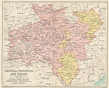
1909 map of the Central Provinces.
Area 
• 1881
48,401 km2 (18,688 sq mi)
Population 

• 1881

2,201,633
History 

• Creation of the division

1861

• Independence of India

1947
Preceded by
Succeeded by
Saugor and Nerbudda Territories
Madhya Pradesh
"The Thug School of Industry, Jubbulpore," a chromolithograph by William Simpson, 1867; this crafts school was meant for the children of dead or imprisoned thugs
Temples in Lameta Ghat near Jubbulpore built by the Beohar dynasty in c. 16-18th century

The Jubbulpore Division, named after its capital Jabalpur (Jubbulpore), was one of the four former administrative divisions of the Central ProvincesofBritish India. It was located in the Mahakoshal region of present-day Madhya Pradesh state of India. The Jubbulpore Division had an area of 48,401 km² with a population of 2,201,633 in 1881.[1]

The Central Provinces became the Central Provinces and Berar in 1936 until the Independence of India.

History

[edit]

Immediately after occupation of the area around Jubbulpore the British authorities established a provisional administration under the superintendent of Political Affairs of Bundelkhand. In 1820 a division containing 12 districts was formed which was known as the Agency of the Saugor and Nerbudda Territories.[2][3] This new division was placed under an agent of the general governor at Jubbulpore.[4]

Jubbulpore Division was established in 1861 when the Saugor and Nerbudda Territories were merged with Nagpur Province, which the British had annexed in 1853, in order to form the Central Provinces.[5]

Territory

[edit]

There were 11 towns and 8501 villages in the Jubbulpore Division. After the Independence of India it became the Jabalpur division of the state of Madhya Pradesh.

Districts

[edit]

The Jubbulpore Division included the following districts:

See also

[edit]

References

[edit]
  1. ^ Hunter, William Wilson, Sir, et al. (1908). Imperial Gazetteer of India, Volume 6. 1908-1931; Clarendon Press, Oxford.
  • ^ Henry Harpur SpryModern India: With Illustrations of the Resources and Capabilities of Hindustan, Volume 2. London 1837
  • ^ Chisholm, Hugh, ed. (1911). "Jubbulpore" . Encyclopædia Britannica. Vol. 15 (11th ed.). Cambridge University Press. p. 532.
  • ^ "History of Sagar". Archived from the original on 2014-08-11. Retrieved 2014-08-01.
  • ^ Philip F. McEldowney (1980). Colonial Administration and Social Developments in middle India: The Central Provinces, 1861-1921 - Ph. D. Dissertation. University of Virginia.
  • Further reading

    [edit]

    23°09′N 79°56′E / 23.150°N 79.933°E / 23.150; 79.933


    Retrieved from "https://en.wikipedia.org/w/index.php?title=Jubbulpore_Division&oldid=1212267974"

    Categories: 
    States and territories established in 1861
    States and territories disestablished in 1947
    Divisions of British India
    States and territories established in 1853
    1861 establishments in British India
    Hidden categories: 
    Wikipedia articles incorporating a citation from the 1911 Encyclopaedia Britannica with Wikisource reference
    Pages using gadget WikiMiniAtlas
    Articles with short description
    Short description matches Wikidata
    Coordinates on Wikidata


    This page was last edited on 6 March 2024, at 23:58 (UTC).

    Text is available under the Creative Commons Attribution-ShareAlike License 4.0; additional terms may apply. By using this site, you agree to the Terms of Use and Privacy Policy. Wikipedia® is a registered trademark of the Wikimedia Foundation, Inc., a non-profit organization.


    Privacy policy

    About Wikipedia

    Disclaimers

    Contact Wikipedia

    Code of Conduct

    Developers

    Statistics

    Cookie statement

    Mobile view


    Wikimedia Foundation
    Powered by MediaWiki