Jump to content


Main menu


Navigation  


Main page
Contents
Current events
Random article
About Wikipedia
Contact us
Donate


Contribute  


Help
Learn to edit
Community portal
Recent changes
Upload file


Search  


Create account

Log in


Create account
 Log in


Pages for logged out editors learn more  


Contributions
Talk


Contents


(Top)


1 Population  


2 Populated places  


3 References  


Jumgal District


Cebuano
Deutsch
Español
فارسی
Français
Italiano

Қазақша
Кыргызча
Нохчийн
Oʻzbekcha / ўзбекча
پنجابی
Polski
Русский
Svenska
Türkçe


Edit links


Article
Talk


Read
Edit
View history


Tools


Actions  


Read
Edit
View history


General  


What links here
Related changes
Upload file
Special pages
Permanent link
Page information
Cite this page
Get shortened URL
Download QR code
Wikidata item


Print/export  


Download as PDF
Printable version


Appearance


Coordinates: 41°55N 74°30E / 41.917°N 74.500°E / 41.917; 74.500
 

From Wikipedia, the free encyclopedia


Jumgal
Жумгал району
CountryKyrgyzstan
RegionNaryn Region
Area
 • Total4,803 km2 (1,854 sq mi)
Population
 (2021)
 • Total44,866
 • Density9.3/km2 (24/sq mi)
Time zoneUTC+6

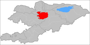
Jumgal (Kyrgyz: Жумгал району, romanizedJumgal rayonu) is a districtofNaryn Region in central Kyrgyzstan. The administrative seat lies at Chaek.[1] Its area is 4,803 square kilometres (1,854 sq mi),[2] and its resident population was 44,866 in 2021.[3] It is a mountainous district. Its main rivers are the Kökömeren (a tributary to the river Naryn) and its tributaries Jumgal, Suusamyr and Batysh Karakol.[4]

Population

[edit]
Historical population
YearPop.±% p.a.
197034,306—    
197941,493+2.14%
198944,613+0.73%
199940,902−0.86%
200940,718−0.05%
202144,866+0.81%
Note: resident population; Sources:[2][3]

Populated places

[edit]

In total, Jumgal District include 30 settlements in 13 rural communities (ayyl aymagy). Each rural community includes one or several villages. The rural communities and settlements in the Jumgal District are as follows:[1][5][6]

  1. Bash-Kuugandy (seat: Bash-Kuugandy)
  2. Bayzak (seat: Bayzak)
  3. Chaek (seat: Chaek; incl. Ak-Tatyr, Besh-Terek, Chukur-Akseki and Shorton)
  4. Chong-Döbö (seat: Chong-Döbö)
  5. Jangy-Aryk (seat: Jangy-Aryk; incl. Bazar-Turuk, Kyzart and Kyzyl-Emgek)
  6. Jumgal (seat: Jumgal; incl. Lama)
  7. Kabak (seat: Tabylgyty; incl. Aral, Keng-Suu, Kotur-Suu, Kyzyl-Korgon, Sary-Bulung and Tabylgy)
  8. Kök-Oy (seat: Kök-Oy; incl. Kichi-Aral)
  9. Kuyruchuk (seat: Kuyruchuk)
  10. Kyzyl-Jyldyz (seat: Kyzyl-Jyldyz)
  11. Ming-Kush (seat: Ming-Kush; incl. Kyzyl-Söök)
  12. Süyümbay (seat: Tash-Döbö)
  13. Tügöl-Say (seat: Tügöl-Say; incl. Epkin)
Jangy-Aryk

Jangy-Aryk

Bazar-Turuk

Bazar-Turuk

Kyzart
Kyzyl- Emgek

Kyzyl-
Emgek

Jumgal

Jumgal

Lama

Lama

Tabylgyty
Aral

Aral

Keng- Suu
Kotur-Suu

Kotur-Suu

Kyzyl- Korgon
Sary-Bulung
Tabylgy

Tabylgy

Kök-Oy
Kichi-Aral

Kichi-Aral

Bayzak
Kuyruchuk

Kuyruchuk

Chong-Döbö
Tügöl- Say

Tügöl-
Say

Epkin

Epkin

Tash-Döbö

Tash-Döbö

Ak-Tatyr

Ak-Tatyr

Besh-Terek

Besh-Terek

Shorton

Shorton

Chukur-Akseki ↓

Chukur-Akseki

←Chaek
Kyzyl-Jyldyz

Kyzyl-Jyldyz

Ming-Kush
Kyzyl-Söök

Kyzyl-Söök

Settlements of the Jumgal District

References

[edit]
  1. ^ a b "Classification system of territorial units of the Kyrgyz Republic" (in Kyrgyz). National Statistics Committee of the Kyrgyz Republic. May 2021. pp. 34–36.
  • ^ a b "2009 population and housing census of the Kyrgyz Republic: Naryn Region" (PDF) (in Russian). National Statistics Committee of the Kyrgyz Republic. 2010. pp. 12, 15.
  • ^ a b "Population of regions, districts, towns, urban-type settlements, rural communities and villages of Kyrgyz Republic" (XLS) (in Russian). National Statistics Committee of the Kyrgyz Republic. 2021. Archived from the original on 10 November 2021.
  • ^ "Жумгал району" [Jumgal District] (PDF). Кыргызстандын Географиясы [Geography of Kyrgyzstan] (in Kyrgyz). Bishkek. 2004. p. 506.{{cite encyclopedia}}: CS1 maint: location missing publisher (link)
  • ^ List of Rural Communities of Kyrgyzstan Archived 2010-02-09 at the Wayback Machine
  • ^ Law 27 September 2012 No. 168 on the transformation of individual urban settlements of the Kyrgyz Republic and relating them to the category of village or city
  • 41°55′N 74°30′E / 41.917°N 74.500°E / 41.917; 74.500

  • t
  • e

  • Retrieved from "https://en.wikipedia.org/w/index.php?title=Jumgal_District&oldid=1230849963"

    Categories: 
    Districts of Naryn Region
    Naryn geography stubs
    Hidden categories: 
    CS1 Kyrgyz-language sources (ky)
    CS1 Russian-language sources (ru)
    CS1 maint: location missing publisher
    Webarchive template wayback links
    Pages using gadget WikiMiniAtlas
    Articles with short description
    Short description is different from Wikidata
    Pages using infobox settlement with no coordinates
    Articles containing Kyrgyz-language text
    Coordinates on Wikidata
    All stub articles


    This page was last edited on 25 June 2024, at 01:58 (UTC).

    Text is available under the Creative Commons Attribution-ShareAlike License 4.0; additional terms may apply. By using this site, you agree to the Terms of Use and Privacy Policy. Wikipedia® is a registered trademark of the Wikimedia Foundation, Inc., a non-profit organization.


    Privacy policy

    About Wikipedia

    Disclaimers

    Contact Wikipedia

    Code of Conduct

    Developers

    Statistics

    Cookie statement

    Mobile view


    Wikimedia Foundation
    Powered by MediaWiki