Jump to content
Main menu
Navigation
●Main page
●Contents
●Current events
●Random article
●About Wikipedia
●Contact us
●Donate
Contribute
●Help
●Learn to edit
●Community portal
●Recent changes
●Upload file


Search
●Create account
●Log in
●Create account
● Log in
Pages for logged out editors learn more
●Contributions
●Talk
(Top)
1
See also
2
References
Kārsava Municipality
●閩南語 / Bân-lâm-gú
●Беларуская
●Беларуская (тарашкевіца)
●Català
●Cebuano
●Deutsch
●Eesti
●Español
●Euskara
●فارسی
●Français
●한국어
●Հայերեն
●Bahasa Indonesia
●Italiano
●ქართული
●Latgaļu
●Latviešu
●Lietuvių
●Македонски
●Nederlands
●Polski
●Русский
●Scots
●Українська
●中文
Edit links
●Article
●Talk
●Read
●Edit
●View history
Tools
Actions
●Read
●Edit
●View history
General
●What links here
●Related changes
●Upload file
●Special pages
●Permanent link
●Page information
●Cite this page
●Get shortened URL
●Download QR code
●Wikidata item
Print/export
●Download as PDF
●Printable version
In other projects
●Wikimedia Commons
Appearance
Coordinates: 56°47′02″N 27°41′05″E / 56.78389°N 27.68472°E / 56.78389; 27.68472
From Wikipedia, the free encyclopedia
Kārsava Municipality
Kārsavas novads
|
|---|
|

Flag

Coat of arms
|
 |
| Country |  Latvia Latvia |
|---|
| Formed | 2021 |
|---|
| Centre | Kārsava |
|---|
|
| • Chairwoman | Ināra Silicka (LZP) |
|---|
|
| • Total | 627.98 km2 (242.46 sq mi) |
|---|
| • Land | 617.63 km2 (238.47 sq mi) |
|---|
| • Water | 10.35 km2 (4.00 sq mi) |
|---|
|
| • Total | 5,127 |
|---|
| • Density | 8.2/km2 (21/sq mi) |
|---|
| Website | www.karsava.lv |
|---|
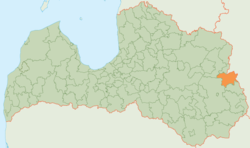
Kārsava Municipality (Latvian: Kārsavas novads) is a former municipalityinLatgale, Latvia. The municipality was formed in 2009 by merging Goliševa Parish, Malnava Parish, Mērdzene Parish, Mežvidi Parish, Salnava Parish and Kārsava town, the administrative centre being Kārsava.
On 1 July 2021, Kārsava Municipality ceased to exist and its territory was merged into Ludza Municipality.[3]
See also
[edit]
References
[edit]
^ [1] Law on Administrative Territories and Populated Areas
56°47′02″N 27°41′05″E / 56.78389°N 27.68472°E / 56.78389; 27.68472
t
e
Retrieved from "https://en.wikipedia.org/w/index.php?title=Kārsava_Municipality&oldid=1064344451"
Categories:
●Kārsava Municipality
●Former municipalities of Latvia
●Latgale geography stubs
Hidden categories:
●CS1 errors: missing title
●CS1 errors: bare URL
●Pages using gadget WikiMiniAtlas
●Articles with short description
●Short description is different from Wikidata
●Pages using infobox settlement with no coordinates
●Articles containing Latvian-language text
●Articles with LNB identifiers
●Articles with MusicBrainz area identifiers
●Coordinates on Wikidata
●All stub articles
●This page was last edited on 7 January 2022, at 22:00 (UTC).
●Text is available under the Creative Commons Attribution-ShareAlike License 4.0;
additional terms may apply. By using this site, you agree to the Terms of Use and Privacy Policy. Wikipedia® is a registered trademark of the Wikimedia Foundation, Inc., a non-profit organization.
●Privacy policy
●About Wikipedia
●Disclaimers
●Contact Wikipedia
●Code of Conduct
●Developers
●Statistics
●Cookie statement
●Mobile view


