Jump to content


Main menu


Navigation  


Main page
Contents
Current events
Random article
About Wikipedia
Contact us
Donate


Contribute  


Help
Learn to edit
Community portal
Recent changes
Upload file


Search  


Create account

Log in


Create account
 Log in


Pages for logged out editors learn more  


Contributions
Talk


Contents


(Top)


1 Location  


2 Overview  


3 Population  


4 Ethnicities  


5 Economic activities  


6 See also  


7 References  


8 External links  


Kabarole District


Asturianu
 / Bân-lâm-gú
Cebuano
Deutsch
Español
فارسی
Français

Bahasa Indonesia
IsiZulu
Italiano
Kiswahili
Luganda
Nederlands

Oʻzbekcha / ўзбекча
Română
اردو


Edit links


Article
Talk


Read
Edit
View history


Tools


Actions  


Read
Edit
View history


General  


What links here
Related changes
Upload file
Special pages
Permanent link
Page information
Cite this page
Get shortened URL
Download QR code
Wikidata item


Print/export  


Download as PDF
Printable version


In other projects  


Wikimedia Commons


Appearance


Coordinates: 00°36N 30°18E / 0.600°N 30.300°E / 0.600; 30.300
 

From Wikipedia, the free encyclopedia


Kabarole District
District location in Uganda
Coordinates: 00°36′N 30°18′E / 0.600°N 30.300°E / 0.600; 30.300
Country Uganda
RegionWestern Uganda
Sub-regionToro sub-region
CapitalBusoro town council proporsed after elevating Fort Portal Municipality to a City on 1 July 2020 hence separating it from Kabarole district
Government
 • LC5 ChairpersonSir Rwabuhinga Richard
Area
 • Total1,814 km2 (700 sq mi)
Population
 (2012 Estimate)
 • Total415,600
Time zoneUTC+3 (EAT)
Websitewww.kabarole.go.ug

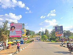
Kabarole District is a districtinWestern Uganda. Kabarole District is part of the Tooro Kingdom. Its main town was Fort Portal before 1 July 2020 when it was elevated to a city, separating it from Kabarole district. The new Kabarole district seat is proporsed in Busoro Town Council. Kabarole remains with only one county (Burahya). Bunyangabu county was curved out to form Bunyangabu district in 2017. Fort Portal Municipality constituency became Fort Portal City in 2020 with an independent local Government.

Location

[edit]

Kabarole District is bordered by Ntoroko District to the north, Kibaale District to the northeast, Kyenjojo District to the east, Kamwenge District to the southeast, Bunyangabu District (which was formerly a county of Kabarole District) to the south, the Democratic Republic of the Congo to the southwest and Bundibugyo District, across the Rwenzori Mountains to the west. Fort Portal, the 'chief town' (Uganda's Tourism City) in the district, lies approximately 320 kilometres (200 mi), by road, west of Kampala, the capital city of Uganda.[1] The coordinates of the district are: 00 36N, 30 18E (Latitude:0.6000; Longitude:30.3000). The surface area is 1,814 km2.[2]

Overview

[edit]

Kabarole Districts consists of one city and one county:[3]

(a) Fort Portal City and (b) Buryahya County. Bunyangabu District which was one of the three counties of Kabarole District got a district started effective 1 July 2017 leaving Kabarole District with just two counties.

Population

[edit]

In 1991, the national census put the population of the district at about 299,600. During the 2002 national census, the district population was about 357,000. In 2012, the population of Kabarole District was estimated at 415,600.[4]

Ethnicities

[edit]

The Batooro, Batuku, and Basongora ethnicities constitute about 52% of the population. The Bakiga constitute 28%, followed by the Bakonjo and the Bamba. The major languages spoken in the district are Rutooro, Rukiga and Runyankore.[5]

Economic activities

[edit]

Subsistence agriculture and animal husbandry are the main economic activities in Kabarole District.

The crops grown in Kabarole District include:

  • Onions/Obutunguru
  • Cassava/Muhoogo
  • Bananas/Ebyenju
  • Matooke (green bananas)/Ebitooke
  • Maize/Ebicooli
  • Beans/Ebihimba
  • Sorghum/Omugusa
  • Potatoes/Ebilaya
  • Sweet potatoes/Ebitakuli
  • Groundnuts/Ebinyobwa
  • Millet/Oburo
  • Yams/Ebinyonga
  • Coffee/Omwani
  • Tea/Amajani
  • Pineapples/Enanasi
  • Tomatoes/Enyanya
  • Cabbage
  • Livestock is the second economic activity practiced in the district. In 2005, there were approximately 18,695 heads of exotic/cross bred cattle, 35,199 indigenous cattle, 75,897 goats, 6,442 sheep, 12,162 pigs, 9,776 exotic/cross bred chicken, 131,255 local chicken, 4,467 ducks, 1,040 turkeys, 326 guinea fowl, and 122 geese in the district.

    Commercial fishing occurs on about 30 of the 52 crater lakes, scattered in Kabarole District. The main fish species harvested from the crater lakes is the small Haplochromines (Nkejje). Fishing, mainly of Protopterus aethiopicus (Lung fish), is also carried out in a number of wetlands. Some fishing also goes on in the area rivers including:

    • River Kayagi
  • River Kaija
  • River Kahomba,
  • River Sogohi
  • River Muzizi
  • River Rwimi
  • River Kakoko
  • River Kakule
  • River Kabago,
  • River Kizikibi
  • River Yerya
  • Aquaculture is practiced with increasing frequency in the district, and in 2005, there were over 300 fish ponds stocked with tilapia and mirror carp species.[6]

    See also

    [edit]

    References

    [edit]
    1. ^ "Road Distance Between Fort Portal And Kampala With Map". Globefeed.com. Retrieved 2 April 2014.
  • ^ "Additional district profile narratives" (PDF). mmv.org. Retrieved 8 October 2016.
  • ^ "Overview of Kabarole District" (PDF). International Food Policy Research Institute. Archived from the original (PDF) on 5 September 2012. Retrieved 21 April 2014.
  • ^ "Estimated Population of Kabarole District In 1991, 2002 & 2012". Citypopulation.de. Retrieved 21 April 2014.
  • ^ "Demographics of Kabarole District" (PDF). International Food Policy Research Institute. Archived from the original (PDF) on 5 September 2012. Retrieved 21 April 2014.
  • ^ "The Economy of Kabarole District" (PDF). International Food Policy Research Institute. Archived from the original (PDF) on 5 September 2012. Retrieved 21 April 2014.
  • [edit]
    Retrieved from "https://en.wikipedia.org/w/index.php?title=Kabarole_District&oldid=1235856403"

    Categories: 
    Kabarole District
    Districts of Uganda
    Hidden categories: 
    Pages using gadget WikiMiniAtlas
    Use dmy dates from May 2023
    Articles with short description
    Short description is different from Wikidata
    Coordinates on Wikidata
    Commons category link is on Wikidata
    Articles with VIAF identifiers
    Articles with J9U identifiers
    Articles with LCCN identifiers


    This page was last edited on 21 July 2024, at 15:52 (UTC).

    Text is available under the Creative Commons Attribution-ShareAlike License 4.0; additional terms may apply. By using this site, you agree to the Terms of Use and Privacy Policy. Wikipedia® is a registered trademark of the Wikimedia Foundation, Inc., a non-profit organization.


    Privacy policy

    About Wikipedia

    Disclaimers

    Contact Wikipedia

    Code of Conduct

    Developers

    Statistics

    Cookie statement

    Mobile view


    Wikimedia Foundation
    Powered by MediaWiki