Jump to content


Main menu


Navigation  


Main page
Contents
Current events
Random article
About Wikipedia
Contact us
Donate


Contribute  


Help
Learn to edit
Community portal
Recent changes
Upload file


Search  


Create account

Log in


Create account
 Log in


Pages for logged out editors learn more  


Contributions
Talk


Contents


(Top)


1 Demography  


2 References  


Kamarang


Deutsch
Español
 

Edit links


Article
Talk


Read
Edit
View history


Tools


Actions  


Read
Edit
View history


General  


What links here
Related changes
Upload file
Special pages
Permanent link
Page information
Cite this page
Get shortened URL
Download QR code
Wikidata item


Print/export  


Download as PDF
Printable version


In other projects  


Wikimedia Commons


Appearance


Coordinates: 5°5155N 60°3651W / 5.86528°N 60.61417°W / 5.86528; -60.61417
 

From Wikipedia, the free encyclopedia


Kamarang
Village
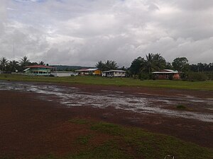
Kamarang looking east
Kamarang is located in Guyana
Kamarang

Kamarang

Location in Guyana

Coordinates: 5°51′55N 60°36′51W / 5.86528°N 60.61417°W / 5.86528; -60.61417
Country Guyana
RegionCuyuni-Mazaruni
Government
 • TypeVillage-Council
Population
 (2012)[1]
 • Total347

5°51′55N 60°36′51W / 5.86528°N 60.61417°W / 5.86528; -60.61417 Kamarang is an Amerindian village,[2] standing at the confluence of the Kamarang River and Mazaruni River, in the Cuyuni-Mazaruni Region of Guyana.

Approach of Kamarang airstrip.Taken from cockpit of Cessna 208 Caravan

Kamarang has a primary school,[3] hospital,[4] police station[5] and can be accessed by air via the Kamarang Airport.[6]

The village has seen extensive economic growth at the start of the 21st century because of gold and diamond mining; however, as of 2019, the output has started to decline.[7] Its altitude is 490 metres (1601 feet).

Demography

[edit]

According to the 2002 population census, it had 349 inhabitants.[8]

Type Officials Professionals and technicians Clergy Trade and Services Agricultural activities Industrial activities Subsistence economy S/D Total
Population 4 5 0 50 4 4 77 77 243
% 1,71 4,94 3,15 23,51 1,67 5,61 15,88 43,90 100,00

References

[edit]
  1. ^ "2012 Population by Village". Statistics Guyana. Retrieved 16 August 2020.
  • ^ "Indigenous village". Ministry of Indigenous Peoples’ Affairs. Retrieved 18 August 2020.
  • ^ "$30M primary school for Kamarang". Department of Public Information. Retrieved 17 August 2020.
  • ^ "New Doctors' Quarters, extension of District Hospital for Kamarang". Department of Public Information. Retrieved 17 August 2020.
  • ^ "Contact numbers for key personnel in all policing divisions". Stabroek News. Retrieved 17 August 2020.
  • ^ "Kamarang Airport". Sky Brary. Retrieved 17 August 2020.
  • ^ "Mined-out areas cool Kamarang's once raging gold fever". Stabroek News. Retrieved 17 August 2020.
  • ^ 2002 Census Data. Town 27 Archived 2012-09-09 at the Wayback Machine

  • t
  • e

  • Retrieved from "https://en.wikipedia.org/w/index.php?title=Kamarang&oldid=1230514700"

    Categories: 
    Populated places in Cuyuni-Mazaruni
    Indigenous villages in Guyana
    Guyana geography stubs
    Hidden categories: 
    Pages using gadget WikiMiniAtlas
    Webarchive template wayback links
    Articles with short description
    Short description is different from Wikidata
    Coordinates on Wikidata
    Commons category link from Wikidata
    All stub articles


    This page was last edited on 23 June 2024, at 04:59 (UTC).

    Text is available under the Creative Commons Attribution-ShareAlike License 4.0; additional terms may apply. By using this site, you agree to the Terms of Use and Privacy Policy. Wikipedia® is a registered trademark of the Wikimedia Foundation, Inc., a non-profit organization.


    Privacy policy

    About Wikipedia

    Disclaimers

    Contact Wikipedia

    Code of Conduct

    Developers

    Statistics

    Cookie statement

    Mobile view


    Wikimedia Foundation
    Powered by MediaWiki