Jump to content


Main menu


Navigation  


Main page
Contents
Current events
Random article
About Wikipedia
Contact us
Donate


Contribute  


Help
Learn to edit
Community portal
Recent changes
Upload file


Search  


Create account

Log in


Create account
 Log in


Pages for logged out editors learn more  


Contributions
Talk


Contents


(Top)


1 Overview  


2 Transport  


3 References  


4 External links  


Kato, Guyana


Add links


Article
Talk


Read
Edit
View history


Tools


Actions  


Read
Edit
View history


General  


What links here
Related changes
Upload file
Special pages
Permanent link
Page information
Cite this page
Get shortened URL
Download QR code
Wikidata item


Print/export  


Download as PDF
Printable version


In other projects  


Wikimedia Commons


Appearance


Coordinates: 4°3918N 59°4922W / 4.6551°N 59.8227°W / 4.6551; -59.8227
 

From Wikipedia, the free encyclopedia


Kato
Village
Kato is located in Guyana
Kato

Kato

Location in Guyana

Coordinates: 4°39′18N 59°49′22W / 4.6551°N 59.8227°W / 4.6551; -59.8227
Country Guyana
RegionPotaro-Siparuni
Government
 • ToshaoClifton Ferreira[1]
Area
 • Total250 km2 (97 sq mi)
Population
 (2012)[3]
 • Total424

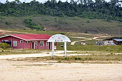
Kato is an indigenous village in the Potaro-Siparuni Region of Guyana. The village is mainly inhabited by Patamona people. The village is located in the Pacaraima Mountains.[4]

Overview

[edit]

The economy of the village is based on farming[2] and gathering semi precious stones which are turned into jewelry at the Monkey Mountain lapidary.[5]

The village has a primary and a secondary school.[1] Kato has access to internet.[6] The nearest hospital is located in Mahdia which can only be accessed by plane.[7]Ahydroelectric plant is under construction on the waterfalls of the nearby Chiung River and will provide electricity for Kato and neighbouring Paramakatoi.[8][9]

Transport

[edit]

There is an unpaved road between Karasabai and Kato.[10] Kato is served by Kato Airport.[11]

References

[edit]
  1. ^ a b "Kato Secondary School finally commissioned". Department of Public Information. Retrieved 2 December 2021.
  • ^ a b "Stranger in Kato". Guyana Chronicle. 1 November 2015. Retrieved 2 December 2021.
  • ^ "2012 Population by Village". Statistics Guyana. Retrieved 2 December 2021.
  • ^ "106-year- old Patamona mother honoured by her community". Kaieteur News. 2 April 2012. Retrieved 2 December 2021.
  • ^ "$10M lapidary for Monkey Mountain on stream". Department of Public Information. Retrieved 1 March 2021.
  • ^ "More internet access for Region 8 communities". Department of Public Information. Retrieved 2 December 2021.
  • ^ "Kato Village needs a hospital". Guyana Chronicle. 24 August 2020. Retrieved 2 December 2021.
  • ^ "$450M Hydropower Plant for Kato village". Department of Public Information. 4 July 2019. Retrieved 2 December 2021.
  • ^ "Kato hydro project to be completed in December". Stabroek News. 7 March 2021. Retrieved 2 December 2021.
  • ^ "Orealla- Moleson Creek link among key road projects this year". Guyana Chronicle. 25 August 2019. Retrieved 2 December 2021.
  • ^ "KTO - Airport". Great Circle Mapper. Retrieved 2 December 2021.
  • [edit]


  • t
  • e

  • Retrieved from "https://en.wikipedia.org/w/index.php?title=Kato,_Guyana&oldid=1223409855"

    Categories: 
    Indigenous villages in Guyana
    Populated places in Potaro-Siparuni
    Patamona
    Guyana geography stubs
    Hidden categories: 
    Pages using gadget WikiMiniAtlas
    Articles with short description
    Short description matches Wikidata
    Coordinates on Wikidata
    Commons category link from Wikidata
    All stub articles


    This page was last edited on 11 May 2024, at 23:19 (UTC).

    Text is available under the Creative Commons Attribution-ShareAlike License 4.0; additional terms may apply. By using this site, you agree to the Terms of Use and Privacy Policy. Wikipedia® is a registered trademark of the Wikimedia Foundation, Inc., a non-profit organization.


    Privacy policy

    About Wikipedia

    Disclaimers

    Contact Wikipedia

    Code of Conduct

    Developers

    Statistics

    Cookie statement

    Mobile view


    Wikimedia Foundation
    Powered by MediaWiki