Jump to content


Main menu


Navigation  


Main page
Contents
Current events
Random article
About Wikipedia
Contact us
Donate


Contribute  


Help
Learn to edit
Community portal
Recent changes
Upload file


Search  


Create account

Log in


Create account
 Log in


Pages for logged out editors learn more  


Contributions
Talk


Contents


(Top)


1 History  


1.1  Ottoman period  


1.1.1  Arab village  


1.1.2  Jewish village  


1.2  British Mandate era  


2 Landmarks  


3 Notable residents  


4 References  


5 Bibliography  


6 External links  


Kfar Tavor


العربية
Cebuano
Čeština
Deutsch
فارسی
Français
עברית
مصرى
Nederlands
Norsk nynorsk
Polski
Русский
Scots
Suomi
Svenska
ייִדיש
 

Edit links


Article
Talk


Read
Edit
View history


Tools


Actions  


Read
Edit
View history


General  


What links here
Related changes
Upload file
Special pages
Permanent link
Page information
Cite this page
Get shortened URL
Download QR code
Wikidata item


Print/export  


Download as PDF
Printable version


In other projects  


Wikimedia Commons


Appearance


Coordinates: 32°4113N 35°2515E / 32.68694°N 35.42083°E / 32.68694; 35.42083
 

From Wikipedia, the free encyclopedia


Kfar Tavor
  • כְּפַר תָּבוֹר
  • كفر تافور
  • Local council (from 1949)
    Watchmen's Square in Kfar Tavor, sculptor: Asaf Lifshitz
    Watchmen's Square in Kfar Tavor, sculptor: Asaf Lifshitz
    Kfar Tavor is located in Northeast Israel
    Kfar Tavor

    Kfar Tavor

    Kfar Tavor is located in Israel
    Kfar Tavor

    Kfar Tavor

    Coordinates: 32°41′13N 35°25′15E / 32.68694°N 35.42083°E / 32.68694; 35.42083
    Grid position189/232 PAL
    DistrictNorthern
    Founded1901
    Government
     • Head of MunicipalityOded Halperin
    Area
     • Total1,231 dunams (1.231 km2 or 304 acres)
    Population
     (2022)[1]
     • Total4,410
     • Density3,600/km2 (9,300/sq mi)

    Kfar Tavor (Hebrew: כְּפַר תָּבוֹר, Arabic: كفر تافور) is a village in the Lower Galilee region of Northern Israel, at the foot of Mount Tabor. Founded in 1901, it was awarded local council status in 1949. In 2022 it had a population of 4,410. As of 2017, nearly all of its citizens are Jewish.[2]

    History

    [edit]

    Ceramics from the Byzantine era have been found here.[3]

    In the early 9th century, under Abbasid rule, Abu Salih Khayr al-Khadim, a eunuch of Caliph al-Mu’tazz b’illah, left all his property in Kfar Tavor (then called Kafr Tabaria) and another Galilee village, Kafr Kanna, to a waqf (religious endowment). The endowments were supposed to be eternal, but were presumably ended by the conquest of the Crusaders in 1099.[4][5][6]

    Ottoman period

    [edit]

    Arab village

    [edit]

    In the Ottoman era there was a village here called Mes'ha.[7] In 1596 the village appeared under the name of "Masha" in the tax registers as part of the nahiya (subdistrict) of Tabariyya in the Sanjak (district) of Safad. It was noted as "hali"(=empty), but a fixed tax-rate of 25% on agricultural product was paid. These products included wheat, barley and cotton; the taxes totalled 3,300 akçe.[8] In 1799 it appeared as Mechi on the map Pierre Jacotin compiled that year.[9]

    In 1881, the Palestine Exploration Fund's Survey of Western Palestine described "Meshah" village with a population of 100 Muslims, with houses chiefly of basalt stone, and a few of adobe and stone. The village was situated on an arable plain, without trees. The water supply was from a cistern in the village.[10]

    Jewish village

    [edit]

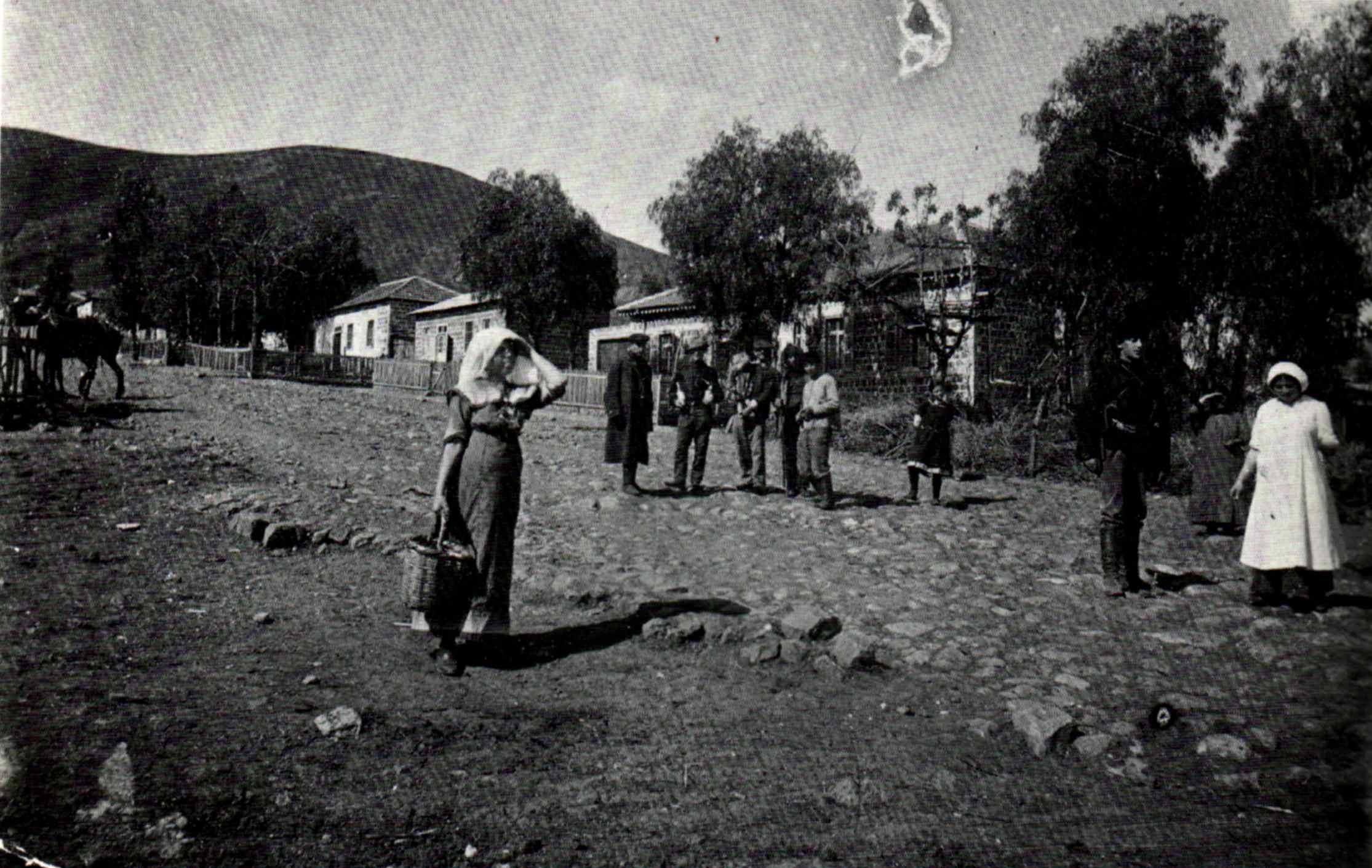
    Kfar Tavor was established in 1901 by pioneers of the First Aliya under the auspices of the Jewish Colonization Association.[11] Twenty-eight farmers settled in the area with the assistance of the philanthropist Baron Edmond de Rothschild. The new settlement was originally known as Mes'ha, the name of the nearby Arab village.[12] It was renamed in 1903 at the urging of Zionist leader Menachem Ussishkin who visited the site and was surprised to find it had no Hebrew name.[13] At first, there was some debate over whether to use the term kfar ("village"), which some residents thought would bode badly for future growth. Ussishkin responded that he had visited the German town of Düsseldorf, which had also originated as a Dorf, or village, but was now a full-fledged city. The Rothschild administration determined that the site was ideal for cultivating grapes. The vineyards of Kfar Tavor became a supplier of grapes to the country's wineries.[citation needed]

    On 12 April 1909 a group of Bar Giora members left Sejera, were they had been based, and met in secret at Kfar Tavor. Led by Israel Shochat and Yitzhak Ben-Zvi it was decided to establish an armed militia - Hashomer. Its members were to act as guards for Jewish colonies and work as laboured towards establishing further colonies.[14]

    British Mandate era

    [edit]
    Kfar Tavor History Museum

    In the 1922 census of Palestine conducted by the British Mandate authorities, Mesha (Kufr Tabur) had a population of 274; all Jews.[15] The 1931 census of Palestine recorded 328 persons in Mas-ha living in 54 houses: 304 Jews, 20 Muslims and 4 Christians.[16]

    In the 1945 statistics Kfar Tavor had 230 inhabitants, all Jews. Mas-ha was noted as an alternative name.[17][18]

    Landmarks

    [edit]

    In the Hameyasdim neighborhood, the core of the village, there is a museum and other sites, including the HaShomer house, the first school and teacher's house (now a library) and a synagogue that was built in 1937. Another school, built in 1911, now serves as the Shenkar Tzfira Music Center. The main street of the neighborhood has houses left from the village's early days, as well as parts of the wall that surrounded it.[13]

    Notable residents

    [edit]
    Major General Yigal Allon (1948–49)

    References

    [edit]
    1. ^ "Regional Statistics". Israel Central Bureau of Statistics. Retrieved 21 March 2024.
  • ^ https://www.cbs.gov.il/he/publications/doclib/2019/local_authorities17_1759/745_0047.pdf [bare URL PDF]
  • ^ Dauphin, 1998, p. 730
  • ^ Mehmet Tutuncu and Lotfi L Abdeljaouad, 2021, Earliest Islamic Waqf on stone
  • ^ Earliest waqf legacy in the world is deciphered: Two villages in Palestine, Ruth Schuster, Dec. 5, 2021, Haaretz
  • ^ The earliest known Waqf inscription in stone; a large and impressive calligraphic marble stele, Near East or Egypt, circa 880-900, 8 Oct 2015; Christie's
  • ^ "The place of unction", according to Palmer, 1881, p. 131
  • ^ Hütteroth and Abdulfattah, 1977, p. 187
  • ^ Karmon, 1960, p. 167 Archived 2019-12-22 at the Wayback Machine
  • ^ Conder and Kitchener, 1881, SWP I, p. 361
  • ^ Ben-Porat, Amir (1991). "Immigration, proletarianization, and deproletarianization A case study of the Jewish working class in Palestine, 1882–1914". Theory and Society (20): 244.
  • ^ Marom, Roy. "The Abu Hameds of Mulabbis: An Oral History of a Palestinian Village Depopulated in the Late Ottoman Period". British Journal of Middle Eastern Studies. 48: 2.
  • ^ a b "Our village - Kfar Tavor". Archived from the original on 2012-05-13. Retrieved 2009-08-20.
  • ^ Segev, Tom (2018 - 2019 translation Haim Watzman) A State at Any Cost. The Life of David Ben-Gurion. Apollo. ISBN 9-781789-544633 p.96
  • ^ Barron, 1923, Table XI, Sub-district of Tiberias, p. 39
  • ^ E. Mills, ed. (1932). Census of Palestine 1931. Population of Villages, Towns and Administrative Areas. Jerusalem: Government of Palestine. p. 83.
  • ^ Department of Statistics, 1945, p. 8
  • ^ Government of Palestine, Department of Statistics. Village Statistics, April, 1945. Quoted in Hadawi, 1970, p. 62
  • Bibliography

    [edit]
  • Conder, C.R.; Kitchener, H.H. (1881). The Survey of Western Palestine: Memoirs of the Topography, Orography, Hydrography, and Archaeology. Vol. 1. London: Committee of the Palestine Exploration Fund.
  • Dauphin, C. (1998). La Palestine byzantine, Peuplement et Populations. BAR International Series 726 (in French). Vol. III : Catalogue. Oxford: Archeopress. ISBN 0-860549-05-4.
  • Department of Statistics (1945). Village Statistics, April, 1945. Government of Palestine.
  • Karmon, Y. (1960). "An Analysis of Jacotin's Map of Palestine" (PDF). Israel Exploration Journal. 10 (3, 4): 155–173, 244–253. Archived from the original (PDF) on 2019-12-22. Retrieved 2015-04-22.
  • Hadawi, S. (1970). Village Statistics of 1945: A Classification of Land and Area ownership in Palestine. Palestine Liberation Organization Research Centre.
  • Hütteroth, Wolf-Dieter; Abdulfattah, Kamal (1977). Historical Geography of Palestine, Transjordan and Southern Syria in the Late 16th Century. Erlanger Geographische Arbeiten, Sonderband 5. Erlangen, Germany: Vorstand der Fränkischen Geographischen Gesellschaft. ISBN 3-920405-41-2.
  • Palmer, E.H. (1881). The Survey of Western Palestine: Arabic and English Name Lists Collected During the Survey by Lieutenants Conder and Kitchener, R. E. Transliterated and Explained by E.H. Palmer. Committee of the Palestine Exploration Fund.
  • [edit]
    Retrieved from "https://en.wikipedia.org/w/index.php?title=Kfar_Tavor&oldid=1158268387"

    Categories: 
    Local councils in Northern District (Israel)
    Populated places established in 1901
    Lower Galilee
    Mount Tabor
    Hidden categories: 
    Pages using gadget WikiMiniAtlas
    All articles with bare URLs for citations
    Articles with bare URLs for citations from March 2022
    Articles with PDF format bare URLs for citations
    Webarchive template wayback links
    Articles with short description
    Short description is different from Wikidata
    Articles containing Hebrew-language text
    Articles containing Arabic-language text
    Coordinates on Wikidata
    Pages using infobox settlement with missing country
    All articles with unsourced statements
    Articles with unsourced statements from November 2015
    CS1: long volume value
    CS1 French-language sources (fr)
    Articles with VIAF identifiers
    Articles with J9U identifiers


    This page was last edited on 3 June 2023, at 00:38 (UTC).

    Text is available under the Creative Commons Attribution-ShareAlike License 4.0; additional terms may apply. By using this site, you agree to the Terms of Use and Privacy Policy. Wikipedia® is a registered trademark of the Wikimedia Foundation, Inc., a non-profit organization.


    Privacy policy

    About Wikipedia

    Disclaimers

    Contact Wikipedia

    Code of Conduct

    Developers

    Statistics

    Cookie statement

    Mobile view


    Wikimedia Foundation
    Powered by MediaWiki