Jump to content


Main menu


Navigation  


Main page
Contents
Current events
Random article
About Wikipedia
Contact us
Donate


Contribute  


Help
Learn to edit
Community portal
Recent changes
Upload file


Search  


Create account

Log in


Create account
 Log in


Pages for logged out editors learn more  


Contributions
Talk


Contents


(Top)


1 History  


1.1  Ottoman era  


1.2  British Mandate era  


1.3  State of Israel  


2 Jordan Lead Codices  


3 See also  


4 References  


5 Bibliography  


6 External links  


ShibliUmm al-Ghanam


العربية
Čeština
עברית
Norsk nynorsk
Polski
Русский
 

Edit links


Article
Talk


Read
Edit
View history


Tools


Actions  


Read
Edit
View history


General  


What links here
Related changes
Upload file
Special pages
Permanent link
Page information
Cite this page
Get shortened URL
Download QR code
Wikidata item


Print/export  


Download as PDF
Printable version


In other projects  


Wikimedia Commons


Appearance


Coordinates: 32°4103N 35°2349E / 32.68417°N 35.39694°E / 32.68417; 35.39694
 

From Wikipedia, the free encyclopedia


Shibli–Umm al-Ghanam
  • שִׁבְּלִי-אֻם אל-עַ'נַם
  • الشبلي - أم الغنم
  • Local council (from 1992)
    Hebrew transcription(s)
     • ISO 259Šibbli - ʔumm ˀel-Ránem
    (Israeli pronunciation)
    View of Shibli
    View of Shibli
    Shibli–Umm al-Ghanam is located in Northeast Israel
    Shibli–Umm al-Ghanam

    Shibli–Umm al-Ghanam

    Shibli–Umm al-Ghanam is located in Israel
    Shibli–Umm al-Ghanam

    Shibli–Umm al-Ghanam

    Coordinates: 32°41′03N 35°23′49E / 32.68417°N 35.39694°E / 32.68417; 35.39694
    Grid position186/231 PAL
    CountryIsrael
    DistrictNorthern District
    Founded1992
    Area
     • Total2,879 dunams (2.879 km2 or 1.112 sq mi)
    Population
     (2022)[1]
     • Total6,370
     • Density2,200/km2 (5,700/sq mi)
    Name meaningKhirbet Umm el Ghanem = The ruin with the sheep[2]

    Shibli–Umm al-Ghanam (Arabic: الشبلي - أم الغنم, Hebrew: שִׁבְּלִי-אֻם אל-עַ'נַם) is an Arab town at the foot of Mount TaborinIsrael's Northern District. In 2022 it had a population of 6,370.[1]

    History[edit]

    Archaeological excavations east of the village have revealed flint from the Mousterian culture, several knapped using the Levallois technique.[3]

    Ceramics from the Byzantine era have been found here.[4]

    Ottoman era[edit]

    In 1517, the village was included in the Ottoman empire with the rest of Palestine, and in the 1596 tax-records it appeared as Um al-Ganam, located in the NahiyaofTabariyya, part of Safad Sanjak. The population was 8 households, all Muslim. They paid a fixed tax-rate of 25% on agricultural products, including wheat, barley and summer crops, in addition to occasional revenues, and goats and beehives; a total of 1,910 akçe.[5][6]

    In 1875, Victor Guérin found here "several ancient cisterns, still unbroken, and ancient caves cut in rock, which now serve as refuge for shepherds."[7] In 1881 the Palestine Exploration Fund's Survey of Western Palestine found at Kh. Umm el Ghanem: "Heaps of stones, a few of which are hewn, all of small size, one small cave and one cistern."[8]

    British Mandate era[edit]

    In the 1922 census of Palestine conducted by the British Mandate authorities, Umm al Ghanam had a population of 52, all Muslims.[9] In the 1931 census the population of Umm al-Ghanam was counted with that of Reineh, together they had 1015 inhabitants in a total of 243 houses.[10]

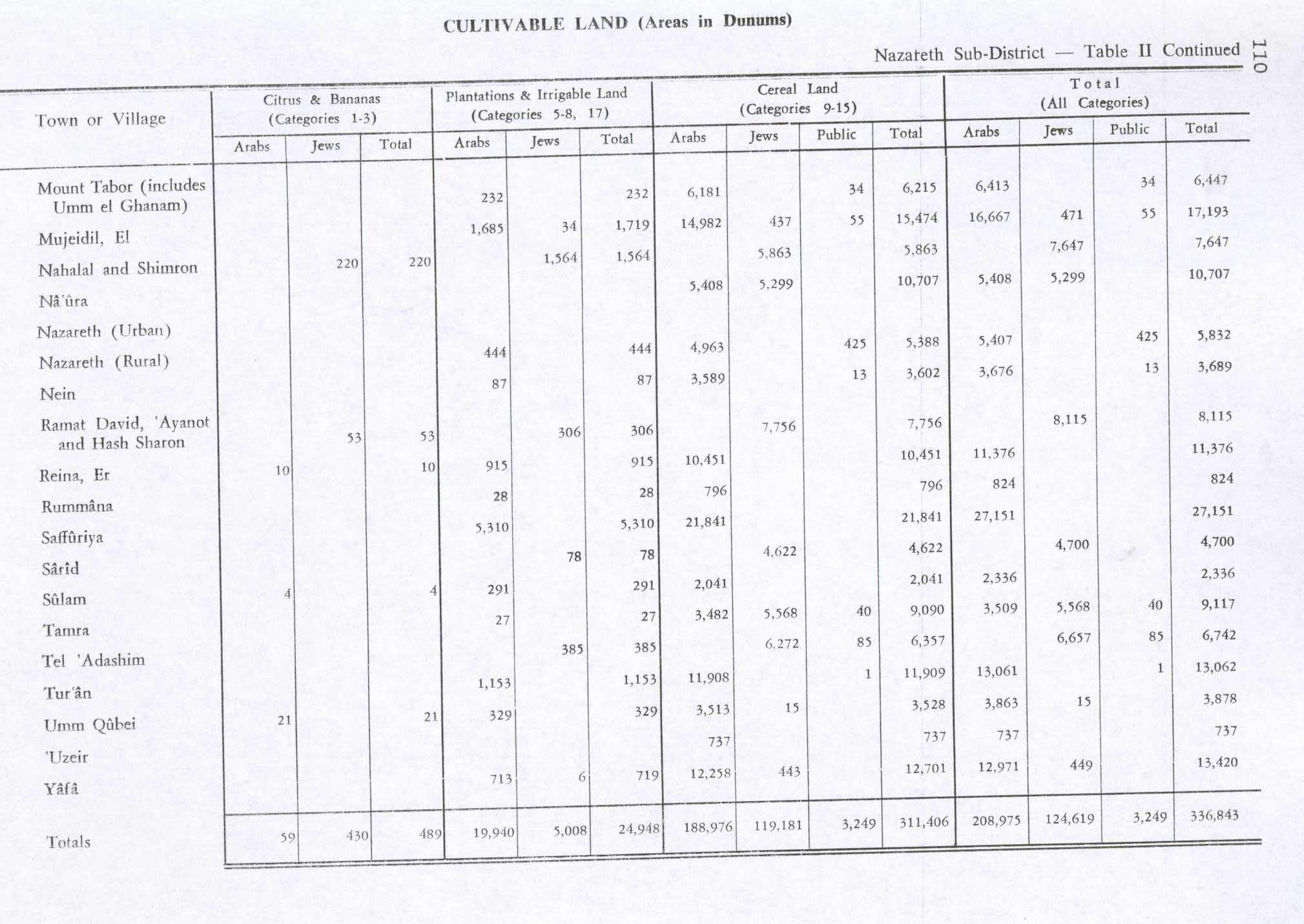
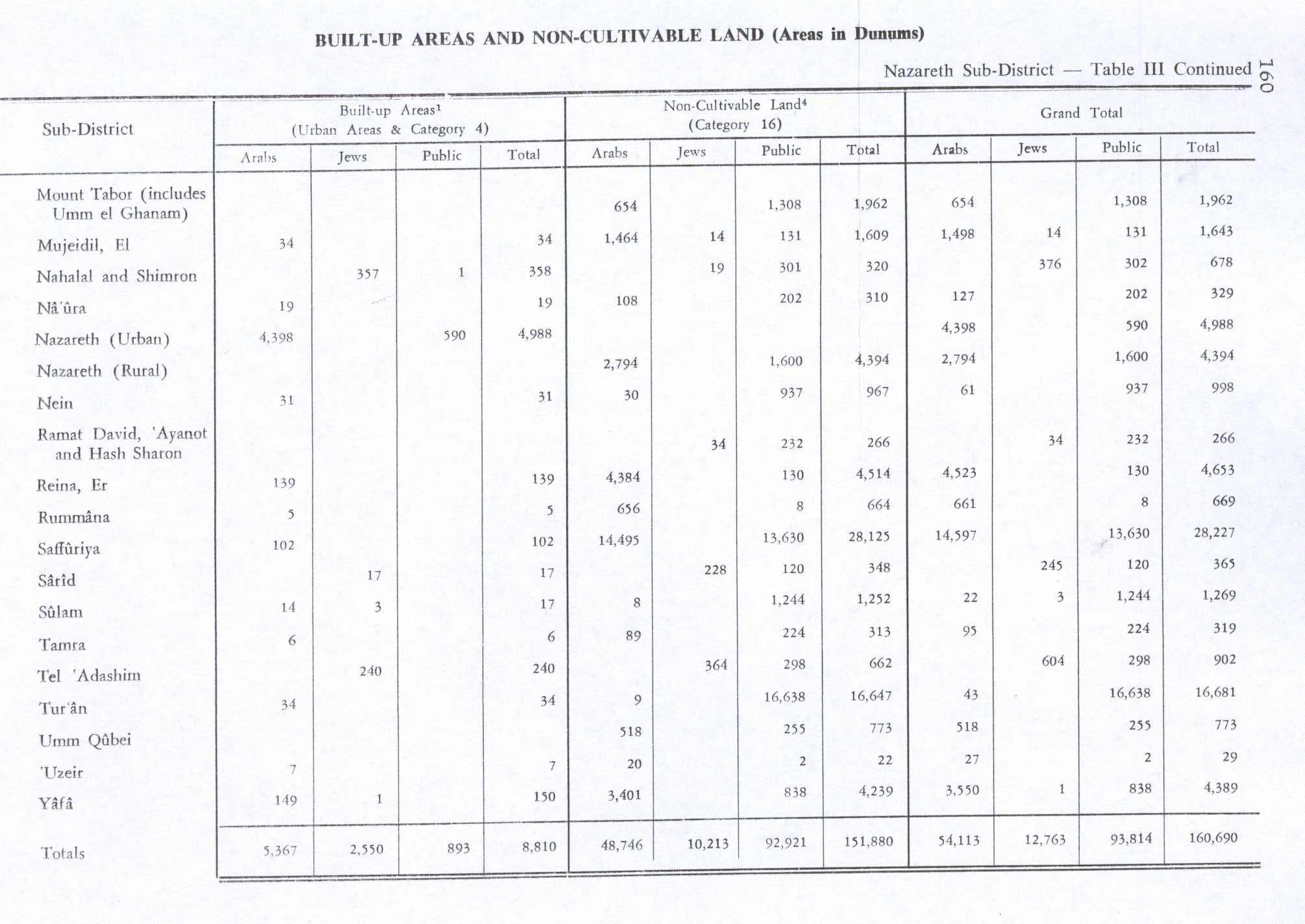
    In the 1945 statistics the population of Umm al-Ghanam was counted with that of Mount Tabor, and their total land area was 8,409 dunams, according to an official land and population survey.[11][12] Of this, 232 dunams were allocated for plantations and irrigable land, 6,215 for cereals,[13] while a total of 1,962 dunams were classified as non-cultivable land.[14]

    State of Israel[edit]

    The town was formed in 1992 as a result of a municipal merger of the villages of Shibli and Umm al-Ghanam.

    Shibli High School is attended by 270 Arab students, Special educational programs introduced at the school have boosted the Bagrut matriculation pass rate and percentage of graduates attending university.[15]

    Jordan Lead Codices[edit]

    The so-called Jordan Lead Codices are considered by Israeli and Jordanian specialists to be fakes.

    Hassan Saida of Shibli–Umm Al-Ghanam owns a collection of small cast lead books featuring what is believed to be the first-ever portrait of Jesus. The books are thought to have been created by followers of Jesus in the first decades after his crucifixion. The books, containing cryptic messages in Hebrew and ancient Greek, have been in Saida's family since they were found by his great-grandfather.[16]

    See also[edit]

    References[edit]

    1. ^ a b "Regional Statistics". Israel Central Bureau of Statistics. Retrieved 21 March 2024.
  • ^ Palmer, 1881, p. 130
  • ^ Tepper, 2015, ‘Ein Umm el-Ghanam
  • ^ Dauphin, 1998, p. 731
  • ^ Hütteroth and Abdulfattah, 1977, p. 189
  • ^ Note that Rhode, 1979, p. 6 Archived 10 October 2016 at the Wayback Machine writes that the register that Hütteroth and Abdulfattah studied was not from 1595/6, but from 1548/9
  • ^ Guérin, 1880, p. 140; as given in Conder and Kitchener, SWP I, p. 409
  • ^ Conder and Kitchener, 1881, SWP I, p. 409
  • ^ Barron, 1923, Table XI, Sub-district of Nazareth, p. 38
  • ^ Mills, 1932, p.73
  • ^ Department of Statistics, 1945, p. 8
  • ^ Government of Palestine, Department of Statistics. Village Statistics, April, 1945. Quoted in Hadawi, 1970, p. 62
  • ^ Government of Palestine, Department of Statistics. Village Statistics, April, 1945. Quoted in Hadawi, 1970, p. 110
  • ^ Government of Palestine, Department of Statistics. Village Statistics, April, 1945. Quoted in Hadawi, 1970, p. 160
  • ^ "Shibli High School", World ORT, Archived 2014-12-20 at the Wayback Machine
  • ^ Lost for 2,000 years... Could this be the first portrait of Jesus?
  • Bibliography[edit]

  • Conder, C.R.; Kitchener, H.H. (1881). The Survey of Western Palestine: Memoirs of the Topography, Orography, Hydrography, and Archaeology. Vol. 1. London: Committee of the Palestine Exploration Fund.
  • Dauphin, C. (1998). La Palestine byzantine, Peuplement et Populations. BAR International Series 726 (in French). Vol. III : Catalogue. Oxford: Archeopress. ISBN 0-860549-05-4.
  • Government of Palestine, Department of Statistics (1945). Village Statistics, April, 1945.
  • Guérin, V. (1880). Description Géographique Historique et Archéologique de la Palestine (in French). Vol. 3: Galilee, pt. 1. Paris: L'Imprimerie Nationale.
  • Hadawi, S. (1970). Village Statistics of 1945: A Classification of Land and Area ownership in Palestine. Palestine Liberation Organization Research Center.
  • Hütteroth, Wolf-Dieter; Abdulfattah, Kamal (1977). Historical Geography of Palestine, Transjordan and Southern Syria in the Late 16th Century. Erlanger Geographische Arbeiten, Sonderband 5. Erlangen, Germany: Vorstand der Fränkischen Geographischen Gesellschaft. ISBN 3-920405-41-2.
  • Mills, E., ed. (1932). Census of Palestine 1931. Population of Villages, Towns and Administrative Areas. Jerusalem: Government of Palestine.
  • Palmer, E.H. (1881). The Survey of Western Palestine: Arabic and English Name Lists Collected During the Survey by Lieutenants Conder and Kitchener, R. E. Transliterated and Explained by E.H. Palmer. Committee of the Palestine Exploration Fund.
  • Rhode, H. (1979). Administration and Population of the Sancak of Safed in the Sixteenth Century. Columbia University. Archived from the original on 1 March 2020. Retrieved 2 December 2017.
  • Tepper, Y. (2 March 2015). "'Ein Umm el-Ghanam" (127). Hadashot Arkheologiyot – Excavations and Surveys in Israel. {{cite journal}}: Cite journal requires |journal= (help)
  • External links[edit]


    Retrieved from "https://en.wikipedia.org/w/index.php?title=Shibli–Umm_al-Ghanam&oldid=1221066894"

    Categories: 
    Arab localities in Israel
    Local councils in Northern District (Israel)
    Mount Tabor
    Hidden categories: 
    Pages using gadget WikiMiniAtlas
    Webarchive template wayback links
    Use dmy dates from June 2023
    Articles with short description
    Short description is different from Wikidata
    Articles containing Hebrew-language text
    Articles containing Arabic-language text
    Coordinates on Wikidata
    CS1: long volume value
    CS1 French-language sources (fr)
    CS1 errors: missing periodical


    This page was last edited on 27 April 2024, at 17:21 (UTC).

    Text is available under the Creative Commons Attribution-ShareAlike License 4.0; additional terms may apply. By using this site, you agree to the Terms of Use and Privacy Policy. Wikipedia® is a registered trademark of the Wikimedia Foundation, Inc., a non-profit organization.


    Privacy policy

    About Wikipedia

    Disclaimers

    Contact Wikipedia

    Code of Conduct

    Developers

    Statistics

    Cookie statement

    Mobile view


    Wikimedia Foundation
    Powered by MediaWiki