Jump to content


Main menu


Navigation  


Main page
Contents
Current events
Random article
About Wikipedia
Contact us
Donate


Contribute  


Help
Learn to edit
Community portal
Recent changes
Upload file


Search  


Create account

Log in


Create account
 Log in


Pages for logged out editors learn more  


Contributions
Talk


Contents


(Top)


1 River Basin  


2 Kolar Dam  


3 References  


Kolar River (Madhya Pradesh)


Cebuano


ி
 

Edit links


Article
Talk


Read
Edit
View history


Tools


Actions  


Read
Edit
View history


General  


What links here
Related changes
Upload file
Special pages
Permanent link
Page information
Cite this page
Get shortened URL
Download QR code
Wikidata item


Print/export  


Download as PDF
Printable version


Appearance


Coordinates: 21°14N 79°10E / 21.233°N 79.167°E / 21.233; 79.167
 

From Wikipedia, the free encyclopedia


Kolar River
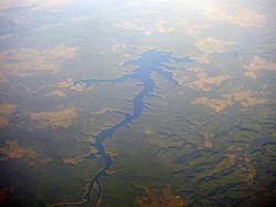
The Kolar Reservoir, created by the Kolar Dam across the river.
Location
CountryIndia
StateMadhya Pradesh
Physical characteristics
MouthNarmada River

 • coordinates

21°14′N 79°10′E / 21.233°N 79.167°E / 21.233; 79.167
Length101 km (63 mi)

The Kolar is a right bank tributary of the Narmada River. It flows for a total length of 101 km, all of which is in the state of Madhya Pradesh.[1]

River Basin[edit]

The Kolar river arises in the Vindhya RangeofSehore district and flows in a south westerly direction to meet the Narmada at village neelkanth near Nasrullahganj in the Sehore district of Madhya Pradesh. Its total drainage area is of 1,347 km2. is spread across the two districts.[1] The upper part of the river basin lies at an elevation of 350 to 600 metres and much of it is under tropical deciduous forest. The river debouches into the plains near Jholiapur. Much of the upper basin has poor soils and agriculture here is largely of wheat and gram. The lower basin has better soils and a flatter slope and has been used extensively bunded allowing for impounding water during the monsoons.[1]

Kolar Dam[edit]

Near Lawakhadi in Sehore, the Kolar Dam, a masonry dam has been built across the river and it provides about 70% filtered water to Bhopal city and provides for irrigation and inland fisheries.[2]

References[edit]

  1. ^ a b c Jain, Sharad (2007). Hydrology and Water Resources of India. Netherlands: Springer. p. 521. ISBN 9781402051791.
  • ^ Sugunan, VV (1995). Reservoir Fisheries of India. Rome: FAO. p. 263. ISBN 9789251036730.

  • t
  • e

  • Retrieved from "https://en.wikipedia.org/w/index.php?title=Kolar_River_(Madhya_Pradesh)&oldid=1152677805"

    Categories: 
    Rivers of Madhya Pradesh
    Tributaries of the Narmada River
    India river stubs
    Hidden categories: 
    Pages using gadget WikiMiniAtlas
    Use dmy dates from August 2019
    Articles with short description
    Short description matches Wikidata
    Coordinates on Wikidata
    All stub articles


    This page was last edited on 1 May 2023, at 16:59 (UTC).

    Text is available under the Creative Commons Attribution-ShareAlike License 4.0; additional terms may apply. By using this site, you agree to the Terms of Use and Privacy Policy. Wikipedia® is a registered trademark of the Wikimedia Foundation, Inc., a non-profit organization.


    Privacy policy

    About Wikipedia

    Disclaimers

    Contact Wikipedia

    Code of Conduct

    Developers

    Statistics

    Cookie statement

    Mobile view


    Wikimedia Foundation
    Powered by MediaWiki