Jump to content


Main menu


Navigation  


Main page
Contents
Current events
Random article
About Wikipedia
Contact us
Donate


Contribute  


Help
Learn to edit
Community portal
Recent changes
Upload file


Search  


Create account

Log in


Create account
 Log in


Pages for logged out editors learn more  


Contributions
Talk


Contents


(Top)


1 Demographics  


2 2020 Ukrainian Administrative Reform  


3 Notes  


4 References  


Krasnoperekopsk Raion


Башҡортса
Беларуская
Беларуская (тарашкевіца)
Български
Cebuano
Čeština
Deutsch
Español
Esperanto
Français
Հայերեն
Italiano
Нохчийн
Polski
Qırımtatarca
Română
Русский
Татарча / tatarça
Türkçe
Українська
Tiếng Vit


Edit links


Article
Talk


Read
Edit
View history


Tools


Actions  


Read
Edit
View history


General  


What links here
Related changes
Upload file
Special pages
Permanent link
Page information
Cite this page
Get shortened URL
Download QR code
Wikidata item


Print/export  


Download as PDF
Printable version


In other projects  


Wikimedia Commons


Appearance


Coordinates: 45°5803N 33°4801E / 45.96750°N 33.80028°E / 45.96750; 33.80028
 

From Wikipedia, the free encyclopedia


Krasnoperekopsk Raion
Krasnoperekopsk rayonı
Karkinit Bay, Krasnoperekopsky District
Flag of Krasnoperekopsk Raion
Official seal of Krasnoperekopsk Raion
Map
Raion location within Crimea
Country Ukraine
RepublicCrimea
CapitalKrasnoperekopsk
Subdivisions

List

  • 0 cities
  • 0 towns
  • 38 villages
Area
 • Total1,231 km2 (475 sq mi)
Population
 (2014)
 • Total24,738
 • Density20/km2 (52/sq mi)
Time zoneUTC+3 (MSK)
Dialing code+380-6565

Krasnoperekopsk Raion (Ukrainian: Красноперекопський район, Russian: Красноперекопский район, Crimean Tatar: Krasnoperekopsk rayonı) is one of the 25 districts of the Autonomous Republic of Crimea, a territory recognized by a majority of countries as part of Ukraine, but currently occupied and incorporated by Russia as the Republic of Crimea. It is situated in the northern part of the republic. The administrative center of the raion is the town of Krasnoperekopsk. The latter is not a part of the raion (district) and incorporated separately as a town of regional significance. Population (without Krasnoperekopsk): 24,738 (2014 Census).[1]

On 12 May 2016, Ukrainian authorities[nb 1] renamed the district to Perekop Raion (Ukrainian: Перекопський район) as part of its decommunization efforts. The renaming will be in effect when Ukraine take back control of Crimea.[5]

Demographics[edit]

The Raion had a population of 31.843 according to the 2001 Ukrainian census. The largest ethnic group are Ukrainians, accounting for almost half of the population, followed by Russians, Crimean Tatars and Belarusians.[6] Rural areas are vastly Ukrainophone, while population centers are mostly Russian-speaking. Crimean Tatar is spoken by a significant minority in almost every settlement.[7]

Ethnic composition of Krasnoperekopsk Raion
percent
Ukrainians

43.4%
Russians

33.2%
Crimean Tatars

17.2%
Belarusians

1.2%
others

0.7%
2001 Ukrainian Census
Native language Inhabitants Percentage
Russian 16,958 53,3%
Ukrainian 8,529 26.8%
Crimean Tatar 4,944 15.5%
Belarusian 113 0.4%
others 1.018 3.2%
Total: 31,843 100%
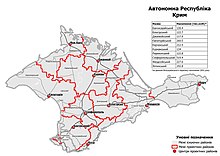
In July 2020, the Verkhovna Rada approved an administrative reform in Crimea

2020 Ukrainian Administrative Reform[edit]

In July 2020, Ukraine conducted an administrative reform throughout its de jure territory. This included Crimea, which was at the time occupied by Russia, and is still ongoing as of October 2023. Crimea was reorganized from 14 raions and 11 municipalities into 10 raions, with municipalities abolished altogether. The territory of Perekop Raion was expanded to also include the territories of Armiansk Municipality, Yani Qapu Municipality, and Rozdolne Raion, but has not yet been implemented due to the ongoing Russian occupation.[8]

Notes[edit]

  1. ^ Since the 2014 Crimean crisis, the status of the Crimea and of the city of Sevastopol is under dispute between Russia and Ukraine; Ukraine and the majority of the international community considers the Crimea and Sevastopol an integral part of Ukraine, while Russia, on the other hand, considers the Crimea and Sevastopol an integral part of Russia, with Sevastopol functioning as a federal city within the Crimean Federal District.[2][3][4]

References[edit]

  1. ^ Russian Federal State Statistics Service (2014). "Таблица 1.3. Численность населения Крымского федерального округа, городских округов, муниципальных районов, городских и сельских поселений" [Table 1.3. Population of Crimean Federal District, Its Urban Okrugs, Municipal Districts, Urban and Rural Settlements]. Федеральное статистическое наблюдение «Перепись населения в Крымском федеральном округе». ("Population Census in Crimean Federal District" Federal Statistical Examination) (in Russian). Federal State Statistics Service. Retrieved January 4, 2016.
  • ^ Gutterman, Steve. "Putin signs Crimea treaty, will not seize other Ukraine regions". Reuters.com. Retrieved 26 March 2014.
  • ^ "Ukraine crisis timeline". BBC News.
  • ^ UN General Assembly adopts resolution affirming Ukraine's territorial integrity Archived 2018-03-04 at the Wayback Machine, China Central Television (28 March 2014)
  • ^ Верховна Рада України; Постанова від 12.05.2016 № 1352-VIII Про перейменування окремих населених пунктів та районів Автономної Республіки Крим та міста Севастополя (in Ukrainian)
  • ^ https://web.archive.org/web/20140410223909/http://sf.ukrstat.gov.ua/
  • ^ https://socialdata.org.ua/projects/mova-2001/
  • ^ "Про утворення та ліквідацію районів". Офіційний вебпортал парламенту України (in Ukrainian). Retrieved 2023-10-16.

  • 45°58′03N 33°48′01E / 45.96750°N 33.80028°E / 45.96750; 33.80028

  • t
  • e

  • Retrieved from "https://en.wikipedia.org/w/index.php?title=Krasnoperekopsk_Raion&oldid=1226714324"

    Categories: 
    Raions of Crimea
    Krasnoperekopsk Raion
    Crimea geography stubs
    Hidden categories: 
    Pages with non-numeric formatnum arguments
    CS1 Russian-language sources (ru)
    Webarchive template wayback links
    Articles with Ukrainian-language sources (uk)
    CS1 Ukrainian-language sources (uk)
    Pages using gadget WikiMiniAtlas
    Articles with short description
    Short description is different from Wikidata
    Pages using infobox settlement with no coordinates
    Articles containing Ukrainian-language text
    Articles containing Russian-language text
    Articles containing Crimean Tatar-language text
    Pages using bar box without float left or float right
    Coordinates on Wikidata
    All stub articles
    Pages using the Kartographer extension


    This page was last edited on 1 June 2024, at 11:09 (UTC).

    Text is available under the Creative Commons Attribution-ShareAlike License 4.0; additional terms may apply. By using this site, you agree to the Terms of Use and Privacy Policy. Wikipedia® is a registered trademark of the Wikimedia Foundation, Inc., a non-profit organization.


    Privacy policy

    About Wikipedia

    Disclaimers

    Contact Wikipedia

    Code of Conduct

    Developers

    Statistics

    Cookie statement

    Mobile view


    Wikimedia Foundation
    Powered by MediaWiki