Jump to content


Main menu


Navigation  


Main page
Contents
Current events
Random article
About Wikipedia
Contact us
Donate


Contribute  


Help
Learn to edit
Community portal
Recent changes
Upload file


Search  


Create account

Log in


Create account
 Log in


Pages for logged out editors learn more  


Contributions
Talk


Contents


(Top)


1 Geography  


2 Administrative divisions  


3 Economy  


4 Transportation  


5 See also  


6 References  


7 External links  


Kimhwa County


 / Bân-lâm-gú
Cebuano
فارسی

Magyar

Norsk bokmål
Polski
Svenska
Tiếng Vit


Edit links


Article
Talk


Read
Edit
View history


Tools


Actions  


Read
Edit
View history


General  


What links here
Related changes
Upload file
Special pages
Permanent link
Page information
Cite this page
Get shortened URL
Download QR code
Wikidata item


Print/export  


Download as PDF
Printable version


Appearance


Coordinates: 38°2443N 127°3546E / 38.41194°N 127.59611°E / 38.41194; 127.59611
 

From Wikipedia, the free encyclopedia
 

(Redirected from Kunwha)

Kimhwa County
김화군
Korean transcription(s)
 • Chosŏn'gŭl김화군
 • Hancha
 • McCune-ReischauerKimhwa-gun
 • Revised RomanizationGimhwa-gun
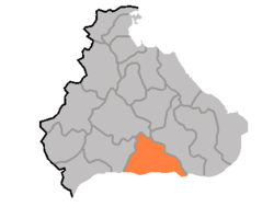
Map of Kangwon showing the location of Kimhwa
CountryNorth Korea
ProvinceKangwŏn Province
Administrative divisions1ŭp, 1 workers' districts, 13 ri
Area
 • Total580 km2 (220 sq mi)
Population
 (2008[1])
 • Total56,541
 • Density97/km2 (250/sq mi)

Kimhwa County is a kun, or county, in Kangwŏn province, North Korea.

Geography[edit]

Kimhwa county is primarily mountainous, but the county's southeastern region is low-lying. The highest peak is Pae'gyŏnsan (백연산). The chief stream is the Pukhan River. Approximately 80% of the county's area is taken up by forestland.

Administrative divisions[edit]

Kimhwa county is divided into 1 ŭp (town), 1 rodongjagu (workers' district) and 13 ri (villages):

  • Kimhwa-ŭp (formerly Kŭmsŏngmyŏn)
  • Hakpang-rodongjagu
  • Ch'angdo-ri
  • Ch'osŏ-ri
  • Kubong-ri
  • Ŏho-ri
  • Pŏpsu-ri
  • Ryonghyŏl-li
  • Sangp'al-li
  • Sinch'ang-ri
  • Sinp'ung-ri
  • Tanghyŏl-li
  • Wŏnbung-ri
  • Wŏndong-ri
  • Wŏnnam-ri

Economy[edit]

The chief local industry is agriculture. Local crops include potatoes, maize, rice, wheat, and barley. In addition, livestock and silkworms are raised, and orchards are cultivated. There are several mines, exploiting local deposits of manganese, gold, copper, talc, fluorite, barite, and anthracite.

Transportation[edit]

Kimhwa is connected to the rest of North Korea by road.

See also[edit]

References[edit]

External links[edit]

38°24′43N 127°35′46E / 38.41194°N 127.59611°E / 38.41194; 127.59611


Retrieved from "https://en.wikipedia.org/w/index.php?title=Kimhwa_County&oldid=1203301140"

Category: 
Counties of Kangwon Province (North Korea)
Hidden categories: 
Pages using gadget WikiMiniAtlas
Articles with short description
Short description is different from Wikidata
Pages using infobox settlement with no coordinates
Articles with VIAF identifiers
Articles with J9U identifiers
Articles with LCCN identifiers
Coordinates on Wikidata


This page was last edited on 4 February 2024, at 16:02 (UTC).

Text is available under the Creative Commons Attribution-ShareAlike License 4.0; additional terms may apply. By using this site, you agree to the Terms of Use and Privacy Policy. Wikipedia® is a registered trademark of the Wikimedia Foundation, Inc., a non-profit organization.


Privacy policy

About Wikipedia

Disclaimers

Contact Wikipedia

Code of Conduct

Developers

Statistics

Cookie statement

Mobile view


Wikimedia Foundation
Powered by MediaWiki