Jump to content


Main menu


Navigation  


Main page
Contents
Current events
Random article
About Wikipedia
Contact us
Donate


Contribute  


Help
Learn to edit
Community portal
Recent changes
Upload file


Search  


Create account

Log in


Create account
 Log in


Pages for logged out editors learn more  


Contributions
Talk


Contents


(Top)


1 Gallery  


2 See also  


3 References  


4 External links  


Lake Minnewanka


Чӑвашла
Cebuano
Español
Français
Italiano
עברית
Nederlands
Oʻzbekcha / ўзбекча
Português
Русский
Српски / srpski
Svenska
Українська
 

Edit links


Article
Talk


Read
Edit
View history


Tools


Actions  


Read
Edit
View history


General  


What links here
Related changes
Upload file
Special pages
Permanent link
Page information
Cite this page
Get shortened URL
Download QR code
Wikidata item


Print/export  


Download as PDF
Printable version


In other projects  


Wikimedia Commons


Appearance


Coordinates: 51°1529N 115°2223W / 51.25806°N 115.37306°W / 51.25806; -115.37306
 

From Wikipedia, the free encyclopedia


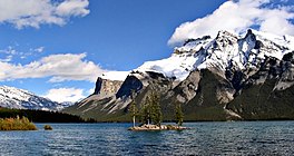
Lake Minnewanka
September 2005
Lake Minnewanka is located in Alberta
Lake Minnewanka

Lake Minnewanka

LocationBanff National Park, Alberta
Coordinates51°15′29N 115°22′23W / 51.25806°N 115.37306°W / 51.25806; -115.37306
Lake typereservoir, natural lake
Primary inflowsCascade River
Basin countriesCanada
Max. length28 km (17 mi)
Max. depth142 m (466 ft)
Surface elevation1,500 metres (4,900 ft)

Lake Minnewanka ( /ˌmɪnəˈwɑːŋkə/) ("Water of the Spirits" in Nakoda) is a glacial lake in the eastern area of Banff National ParkinCanada, about five kilometres (3.1 miles) northeast of the Banff townsite. The lake is 21 km (13 mi) long and 142 m (466 ft) deep, making it the 2nd longest lake in the mountain parks of the Canadian Rockies (the result of a power dam at the west end).[1]

The lake is fed by the Cascade River, flowing east of Cascade Mountain, and runs south through Stewart Canyon as it empties into the western end of the lake. Numerous streams flowing down from Mount Inglismaldie, Mount Girouard and Mount Peechee on the south side of the lake also feed the lake.

Aboriginal people long inhabited areas around Lake Minnewanka, as early as 10,000 years ago, according to stone tools and a Clovis point spearhead discovered by archaeologists. The area is rich in animal life (e.g. elk, mule deer, bighorn sheep, bears) and the easy availability of rock in the mountainous terrain was key to fashioning weapons for hunting.[1]

The western end of the lake can be reached by following Lake Minnewanka road from the Trans-Canada Highway. Boat tours are available near the parking lot. A hiking and mountain biking trail runs along the northern shore of the lake, passing Stewart Canyon and six backcountry campsites.[2] Mount Aylmer which at 3,162 m (10,374 ft) is the highest mountain in this area of the park, is located a few kilometres north of the lake.

The first dam was built in 1912 only to store water. While the National Parks Act was suspended during World War II the much larger embankment dam that still exists was constructed in 1941 and raised the lake 30 m (98 ft). This resulted in the resort village of Minnewanka Landing, which had been there since 1888, being submerged and the Cascade River being diverted away from its old course, resulting in much of the riverbed downstream of the dam running dry for most of the year (except in rare high-water events when the dam's spillway is opened). Most water from the Cascade River is diverted into Two Jack Lake, where it enters a 4-kilometre-long canal. From there it is funnelled into a pair of penstocks feeding two generators in the Cascade Powerhouse with a combined capacity of 34 MW. The facility is owned by TransAlta and supplies power to the Banff Townsite.[3] In order to increase the amount of water entering the penstocks a small diversion dam was built on the Ghost River, which diverts additional water into Lake Minnewanka from the Ghost drainage. Because of the presence of the submerged village, submerged bridge pilings, and submerged dam (the one from 1912) the lake is popular among recreational scuba divers.[4] The construction of the dam resulted in involuntary resettlement of inhabitants from the reservoir area.[5]

Gallery[edit]

  • Lake Minnewanka
    Lake Minnewanka
  • Lake Minnewanka
    Lake Minnewanka
  • Lake Minnewanka
    Lake Minnewanka
  • Two Jack Lake
    Two Jack Lake
  • Lake Minnewanka and Bow River Valley
    Lake Minnewanka and Bow River Valley
  • Lake Minnewanka in winter
    Lake Minnewanka in winter
  • Lake Minnewanka in winter
    Lake Minnewanka in winter
  • Misty Minnewanka lake in late fall
    Misty Minnewanka lake in late fall
  • Panorama of the lake
    Panorama of the lake
  • See also[edit]

    References[edit]

    1. ^ a b "Site Profile: Lake Minnewanka". Alberta Heritage. Archived from the original on 2005-10-27. Retrieved 2005-08-11.
  • ^ Canadian Rockies Archived 2012-10-25 at the Wayback Machine - Banff National Park - Lake Minnewanka
  • ^ "Cascade". TransAlta. 2020.
  • ^ "Diving Lake Minnewanka: Submerged Cultural Resources". Parks Canada. Archived from the original on 2007-08-20. Retrieved 2009-03-14.
  • ^ B. Terminski, Development-Induced Displacement and Resettlement: Causes, Consequences, and Socio-Legal Context, Columbia University Press, New York, 2015.
  • External links[edit]


    Retrieved from "https://en.wikipedia.org/w/index.php?title=Lake_Minnewanka&oldid=1177473146"

    Categories: 
    Lakes of Alberta
    Banff National Park
    Glacial lakes of Canada
    Reservoirs in Alberta
    Hidden categories: 
    Pages using gadget WikiMiniAtlas
    Webarchive template wayback links
    Articles with short description
    Short description is different from Wikidata
    Coordinates on Wikidata
    Articles using infobox body of water without alt
    Articles using infobox body of water without pushpin map alt
    Articles using infobox body of water without image bathymetry
    Commons category link is on Wikidata


    This page was last edited on 27 September 2023, at 18:32 (UTC).

    Text is available under the Creative Commons Attribution-ShareAlike License 4.0; additional terms may apply. By using this site, you agree to the Terms of Use and Privacy Policy. Wikipedia® is a registered trademark of the Wikimedia Foundation, Inc., a non-profit organization.


    Privacy policy

    About Wikipedia

    Disclaimers

    Contact Wikipedia

    Code of Conduct

    Developers

    Statistics

    Cookie statement

    Mobile view


    Wikimedia Foundation
    Powered by MediaWiki