Jump to content


Main menu


Navigation  


Main page
Contents
Current events
Random article
About Wikipedia
Contact us
Donate


Contribute  


Help
Learn to edit
Community portal
Recent changes
Upload file


Search  


Create account

Log in


Create account
 Log in


Pages for logged out editors learn more  


Contributions
Talk


Contents


(Top)


1 Keepers  


2 See also  


3 References  


4 External links  


Langara Light


Français
 

Edit links


Article
Talk


Read
Edit
View history


Tools


Actions  


Read
Edit
View history


General  


What links here
Related changes
Upload file
Special pages
Permanent link
Page information
Cite this page
Get shortened URL
Download QR code
Wikidata item


Print/export  


Download as PDF
Printable version


Appearance


Coordinates: 54°1519.4N 133°0333.8W / 54.255389°N 133.059389°W / 54.255389; -133.059389
 

From Wikipedia, the free encyclopedia


Langara Point
Map
LocationHaida Gwaii
British Columbia
Canada
Coordinates54°15′19.4″N 133°03′33.8″W / 54.255389°N 133.059389°W / 54.255389; -133.059389
Tower
Constructed1913
Constructionconcrete tower
Height7.5 metres (25 ft)
Shapehexagonal frustum six ribbed tower with balcony and lantern
Markingswhite tower, red lantern
OperatorCanadian Coast Guard[1]
Heritagerecognized federal heritage building of Canada, heritage lighthouse Edit this on Wikidata
Light
First lit1913 Edit this on Wikidata
Focal height49 metres (161 ft)
Range8 nmi (15 km; 9.2 miEdit this on Wikidata
CharacteristicFl W 5s.

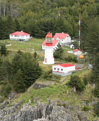
The Langara Point Lighthouse is a staffed lighthouse located atop a scenic bluff on the northwest corner of Langara Island. It is one of only two lighthouses in Haida Gwaii – the other being at Cape St. James (now an automated station), at the southern tip of the islands. Both were built in 1913.

During World War II, the lighthouse was painted camouflage green and a radar station was built here to monitor the North Pacific.

The original light, still in use today, is a first-order Fresnel lens (the largest type of lighthouse lens) manufactured by Chance BrothersofEngland. Each side of the lens is over 8 feet (2.4 m) tall and 5 feet (1.5 m) wide with a focal length of 3 feet (0.91 m).

The lighthouse is easily seen from the water and tours are possible via helicopter. Guests to Langara Island can enjoy a 1-2 hour tour of the lighthouse and its surrounding grounds, usually including a trip up to the top of the light tower, as well as coffee or tea with the lightkeepers.

The Langara Light is one of 12 lighthouses part of the British Columbia Shore Station Oceanographic Program, collecting coastal water temperature and salinity measurements everyday since 1936.[2]

Keepers[edit]

See also[edit]

References[edit]

  1. ^ Rowlett, Russ. "Lighthouses of Canada: Southern British Columbia". The Lighthouse Directory. University of North Carolina at Chapel Hill. Retrieved December 27, 2015.
  • ^ Fisheries and Oceans Canada (2019-03-21). "Data from BC lightstations". www.dfo-mpo.gc.ca. Fisheries and Oceans Canada. Retrieved 2021-02-11.
  • ^ Langara Point Lighthouse Friends
  • External links[edit]

  • icon Engineering

  • t
  • e

  • Retrieved from "https://en.wikipedia.org/w/index.php?title=Langara_Light&oldid=1177377517"

    Categories: 
    Lighthouses completed in 1913
    Lighthouses in British Columbia
    1913 establishments in British Columbia
    Historic buildings and structures in British Columbia
    Canadian lighthouse stubs
    British Columbia building and structure stubs
    Hidden categories: 
    Pages using gadget WikiMiniAtlas
    Articles with short description
    Short description matches Wikidata
    Short description is different from Wikidata
    Infobox mapframe without OSM relation ID on Wikidata
    Coordinates on Wikidata
    All articles using infobox lighthouse
    Articles with admiralty identifiers
    Articles with ARLHS identifiers
    Articles with CCG identifiers
    Articles with NGA identifiers
    All stub articles
    Pages using the Kartographer extension


    This page was last edited on 27 September 2023, at 10:39 (UTC).

    Text is available under the Creative Commons Attribution-ShareAlike License 4.0; additional terms may apply. By using this site, you agree to the Terms of Use and Privacy Policy. Wikipedia® is a registered trademark of the Wikimedia Foundation, Inc., a non-profit organization.


    Privacy policy

    About Wikipedia

    Disclaimers

    Contact Wikipedia

    Code of Conduct

    Developers

    Statistics

    Cookie statement

    Mobile view


    Wikimedia Foundation
    Powered by MediaWiki