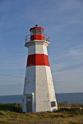
Jump to content


Main menu


Navigation  


Main page
Contents
Current events
Random article
About Wikipedia
Contact us
Donate


Contribute  


Help
Learn to edit
Community portal
Recent changes
Upload file


Search  


Create account

Log in


Create account
 Log in


Pages for logged out editors learn more  


Contributions
Talk


Contents


(Top)


1 History  


2 Notable people  


3 See also  


4 References  


5 External links  


Musquash, New Brunswick


Add links


Article
Talk


Read
Edit
View history


Tools


Actions  


Read
Edit
View history


General  


What links here
Related changes
Upload file
Special pages
Permanent link
Page information
Cite this page
Get shortened URL
Download QR code
Wikidata item


Print/export  


Download as PDF
Printable version


Appearance


Coordinates: 45°1135N 66°1947W / 45.19306°N 66.32972°W / 45.19306; -66.32972
 

From Wikipedia, the free encyclopedia


Musquash Head Lighthouse
Map
LocationMusquash Head, New Brunswick, Canada Edit this at Wikidata
Coordinates45°08′37N 66°14′14W / 45.143628°N 66.237231°W / 45.143628; -66.237231
Tower
Constructed1959 Edit this on Wikidata
Foundationconcrete base
Constructionconcrete tower
Automated1980s Edit this on Wikidata
Height14.3 m (47 ftEdit this on Wikidata
Shapeoctagonal tapered truncated tower with balcony and lantern[1]
Markingswhite tower with a red horizontal band in the upper part, red lantern
Power sourcesolar power Edit this on Wikidata
OperatorMusquash Head Lightstation Inc.[2][3]
Fog signal4s. blast every 60s.
Light
First lit1959 Edit this on Wikidata
Focal height35 m (115 ftEdit this on Wikidata
Range20 nmi (37 km; 23 miEdit this on Wikidata
CharacteristicFl W 3s Edit this on Wikidata
Original lighthouse Edit this at Wikidata
Constructed1879 Edit this on Wikidata
Foundationconcrete base
Constructionwooden tower
Shapesquare truncated tower rising from keeper’s house
Markingswhite tower with a red horizontal band, red lantern
Deactivated1959 Edit this on Wikidata
Focal height34 m (112 ftEdit this on Wikidata

Musquash is a Canadian rural community in Saint John County, New Brunswick. It is located 5 km (3.1 mi) west southwest of the community of Prince of WalesinMusquash Parish.

History

[edit]

Musquash was settled in the early 1800s at the head of navigation on the Musquash River. The Shore Line Railway (later Canadian Pacific Railway) was built through the community but has since been abandoned. The community includes the locales of Ivanhoe, West Musquash and Clinch's Mills. A post office was located in Musquash from 1847 to 1969. It was largely a farming and lumbering community but is now largely an exurbofSaint John, thanks to being located on the Route 1 expressway.

Notable people

[edit]

See also

[edit]

References

[edit]
  1. ^ List of Lights, Pub. 110: Greenland, The East Coasts of North and South America (Excluding Continental U.S.A. Except the East Coast of Florida) and the West Indies (PDF). List of Lights. United States National Geospatial-Intelligence Agency. 2015.
  • ^ Rowlett, Russ. "Lighthouses of Canada: Southern New Brunswick". The Lighthouse Directory. University of North Carolina at Chapel Hill. Retrieved 2017-03-25.
  • ^ Musquash Head, NB Lighthouse Friends. Retrieved 25 March 2017
  • [edit]

    45°11′35N 66°19′47W / 45.19306°N 66.32972°W / 45.19306; -66.32972

  • icon Engineering

  • t
  • e

  • Retrieved from "https://en.wikipedia.org/w/index.php?title=Musquash,_New_Brunswick&oldid=1216420662"

    Categories: 
    Pages using infobox lighthouse with custom Wikidata item
    Communities in Saint John County, New Brunswick
    Lighthouses in New Brunswick
    New Brunswick geography stubs
    Hidden categories: 
    Pages using gadget WikiMiniAtlas
    Use Canadian English from January 2023
    All Wikipedia articles written in Canadian English
    Articles with short description
    Short description is different from Wikidata
    Infobox mapframe without OSM relation ID on Wikidata
    All articles using infobox lighthouse
    Coordinates on Wikidata
    Articles with J9U identifiers
    Articles with admiralty identifiers
    Articles with ARLHS identifiers
    Articles with CCG identifiers
    Articles with NGA identifiers
    All stub articles
    Pages using the Kartographer extension


    This page was last edited on 30 March 2024, at 22:13 (UTC).

    Text is available under the Creative Commons Attribution-ShareAlike License 4.0; additional terms may apply. By using this site, you agree to the Terms of Use and Privacy Policy. Wikipedia® is a registered trademark of the Wikimedia Foundation, Inc., a non-profit organization.


    Privacy policy

    About Wikipedia

    Disclaimers

    Contact Wikipedia

    Code of Conduct

    Developers

    Statistics

    Cookie statement

    Mobile view


    Wikimedia Foundation
    Powered by MediaWiki