Jump to content


Main menu


Navigation  


Main page
Contents
Current events
Random article
About Wikipedia
Contact us
Donate


Contribute  


Help
Learn to edit
Community portal
Recent changes
Upload file


Search  


Create account

Log in


Create account
 Log in


Pages for logged out editors learn more  


Contributions
Talk


Contents


(Top)


1 Geography  


2 Parish church  


3 References  


4 External links  


Launcells


Cebuano
Cymraeg
Euskara
Français
Ladin
Polski
Svenska
Türkçe
 

Edit links


Article
Talk


Read
Edit
View history


Tools


Actions  


Read
Edit
View history


General  


What links here
Related changes
Upload file
Special pages
Permanent link
Page information
Cite this page
Get shortened URL
Download QR code
Wikidata item


Print/export  


Download as PDF
Printable version


In other projects  


Wikimedia Commons


Appearance


Coordinates: 50°4941N 4°2754W / 50.828°N 4.465°W / 50.828; -4.465
 

From Wikipedia, the free encyclopedia


Launcells

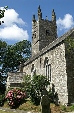
St Swithin's Church, Launcells, in summer

Launcells is located in Cornwall
Launcells

Launcells

Location within Cornwall

Population557 (2011 including Hersham )
OS grid referenceSS265061
Civil parish
  • Launcells
Unitary authority
Ceremonial county
Region
CountryEngland
Sovereign stateUnited Kingdom
Post townBUDE
Postcode districtEX23
Dialling code01288
PoliceDevon and Cornwall
FireCornwall
AmbulanceSouth Western
UK Parliament
List of places
UK
England
Cornwall
50°49′41N 4°27′54W / 50.828°N 4.465°W / 50.828; -4.465

Launcells (Cornish: Lannseles) is a hamlet and civil parish in north-east Cornwall, England, United Kingdom. It is located 3 miles (4.8 km) east of Bude.

Within the civil parish are the hamlets of Launcells Cross, Red Post, Grimscott, and Buttsbear Cross. In 2001, 563 people lived within the civil parish, decreasing to 531 at the 2011 census.[1]

Geography[edit]

The River Tamar forms the eastern boundary of the civil parish, as well as the Cornish boundary with Devon.

Parish church[edit]

The parish church is dedicated to St Swithin: nearby, in the wooded valley is the holy well of St Swithin. There are two aisles but the arcades differ: while the north is of granite the south is of older Polyphant stone. The fine series of over 60 benchends is from the same workshop as those of Kilkhampton and Poughill. Other features of interest are the medieval wall painting and the tomb of Sir John Chamond, 1624.[2]

The church also features an unusual post-Reformation wall painting which has been dated between 1680-1690.

The Ringers of Launcells Tower; painting by Frederick Smallfield

Charles Henderson writing in 1925 gives the dedication as to St Andrew. The origin of the name Launcells is probably from Lan- and a personal name Kellys. In the early Middle Ages the church belonged to Hartland Abbey and there are records of a dispute over the building of the chancel in 1382 which required episcopal intervention. Unusually for a Cornish church it has not been affected by Victorian or later restorations.[3]

References[edit]

  1. ^ "Parish population 2011". Retrieved 10 February 2015.
  • ^ Pevsner, N. (1970) Cornwall, 2nd ed. Penguin Books; p. 95
  • ^ Cornish Church Guide (1925) Truro: Blackford; pp. 136-37
  • External links[edit]

    Media related to Launcells at Wikimedia Commons


    Retrieved from "https://en.wikipedia.org/w/index.php?title=Launcells&oldid=1153949095"

    Categories: 
    Civil parishes in Cornwall
    Hamlets in Cornwall
    Hidden categories: 
    Pages using gadget WikiMiniAtlas
    Use dmy dates from October 2019
    Articles with short description
    Short description is different from Wikidata
    Articles containing Cornish-language text
    Articles with OS grid coordinates
    Coordinates on Wikidata
    Commons category link is on Wikidata


    This page was last edited on 9 May 2023, at 09:30 (UTC).

    Text is available under the Creative Commons Attribution-ShareAlike License 4.0; additional terms may apply. By using this site, you agree to the Terms of Use and Privacy Policy. Wikipedia® is a registered trademark of the Wikimedia Foundation, Inc., a non-profit organization.


    Privacy policy

    About Wikipedia

    Disclaimers

    Contact Wikipedia

    Code of Conduct

    Developers

    Statistics

    Cookie statement

    Mobile view


    Wikimedia Foundation
    Powered by MediaWiki