Leroy, Alabama
| |
|---|---|

Former Leroy Post Office
| |

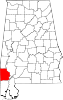
Location of Leroy in Washington County, Alabama.
| |
 Leroy, Alabama Location of Leroy in Alabama | |
| Coordinates: 31°30′17″N 87°59′05″W / 31.50472°N 87.98472°W / 31.50472; -87.98472 | |
| Country | United States |
| State | Alabama |
| County | Washington |
| Area | |
| • Total | 11.98 sq mi (31.02 km2) |
| • Land | 11.91 sq mi (30.85 km2) |
| • Water | 0.07 sq mi (0.17 km2) |
| Elevation | 167 ft (51 m) |
| Population
(2020)
| |
| • Total | 766 |
| • Density | 64.32/sq mi (24.83/km2) |
| Time zone | UTC-6 (Central (CST)) |
| • Summer (DST) | UTC-5 (CDT) |
| ZIP code |
36548
|
| Area code | 251 |
| FIPS code | 01-42304 |
| GNIS feature ID | 156602[2] |
| Other names | Dogwood Level New Canaan Possum Corner[2] |
| [3] | |
Leroy is a census-designated place located in Washington County, Alabama, around 60 miles (97 km) north of Mobile. As of the 2010 census, its population was 911.[4]
| Census | Pop. | Note | %± |
|---|---|---|---|
| 2020 | 766 | — | |
| U.S. Decennial Census[5] | |||
|
Municipalities and communities of Washington County, Alabama, United States
| ||
|---|---|---|
| Towns |
|
|
| CDPs |
| |
| Unincorporated communities |
| |
| Ghost towns |
| |
| Indian reservation |
| |
| Footnotes | ‡This populated place also has portions in an adjacent county or counties | |
| ||
This Washington County, Alabama state location article is a stub. You can help Wikipedia by expanding it. |