Jump to content


Main menu


Navigation  


Main page
Contents
Current events
Random article
About Wikipedia
Contact us
Donate


Contribute  


Help
Learn to edit
Community portal
Recent changes
Upload file


Search  


Create account

Log in


Create account
 Log in


Pages for logged out editors learn more  


Contributions
Talk


Contents


(Top)


1 History  


2 Administrative set-up  


3 Proposals for new districts  


4 See also  


5 References  


6 External links  


List of districts of Arunachal Pradesh


Español
فارسی
Français
ि


Bahasa Melayu

Norsk bokmål
Русский

Simple English
Suomi

اردو


Edit links


Article
Talk


Read
Edit
View history


Tools


Actions  


Read
Edit
View history


General  


What links here
Related changes
Upload file
Special pages
Permanent link
Page information
Cite this page
Get shortened URL
Download QR code
Wikidata item


Print/export  


Download as PDF
Printable version


In other projects  


Wikimedia Commons


Appearance


From Wikipedia, the free encyclopedia


As of February 2024, the Indian state Arunachal Pradesh comprised 28 districts,[1] including Itanagar capital complex,[2] with more districts proposed.[3] Most of the districts are inhabited by various tribal groups. The latest and presently valid official map of districts of Arunachal Pradesh, after the most recent new districts were last announced on 30 August 2018, is in the external links.

History[edit]

Year of formation of districts in Arunachal Pradesh
1965 [5] Kameng, Subansiri, Siang, Lohit and Tirap
1972 [6] Itanagar Capital Complex[2]
1980 [10] Lower Subansiri, Upper Subansiri, Lohit, Dibang Valley, East Siang, West Siang, East Kameng, West Kameng, Tirap
1984 [11] Tawang
1987 [12] Changlang
1992 [13] Papum Pare
1994 [14] Upper Siang
2001 [16] Kurung Kumey, Lower Dibang Valley
2004 [17] Anjaw
2012 [18] Longding
2014 [19] Namsai
2015 [21] Kra Daadi, Siang
2017 [23] Lower Siang, Kamle
2018 [26] Pakke-Kessang, Lepa-Rada, Shi-Yomi
2024 [28] Bichom[2] Keyi Panyor[2]
Numbers in brackets represent total number of districts in the state
  1. The erstwhile Lohit district was divided into two districts: Lohit district and Dibang Valley district.[5]
  2. Siang district was bifurcated into two districts: East Siang district and West Siang district.[6]
  3. Seppa and Bomdila sub-divisions of the Kameng district were transformed into East Kameng district and West Kameng district, respectively.[7][8]
  1. Pakke-Kesang carved out of East Kameng district with five administrative units namely Pakke-Kessang, Seijosa, Pijiriang, Passa Valley and Dissingn Passo with district headquarters at Lemmi.
  2. Lepa-Rada created by bifurcating the Lower Siang district with headquarters at Basar and 4 administrative units namely Tirbin, Basar, Daring and Sago.
  3. Shi-Yomi created by bifurcating the West Siang district with its headquarters at Tato and 4 administrative units namely Mechuka, Tato, Pidi and Manigong.[23]
  1. Bichom from 20 villages from West Kameng and 11 from East Kameng district.[2] It entails 3 circles – Bana, Richikrong and Lada – where Aka and Nyishi tribes live.[citation needed]
  2. Keyi Panyor with 195 villages carved out from Lower Subansiri district and will also include Ter Gapin and Sam Sath area.[2]

Administrative set-up[edit]

West Kameng
Pakke-Kessang
East Kameng
Kurung Kumey
Papum Pare
Lower Subansiri
Kamle
Kra Daadi
Upper Subansiri
Lower Siang
Lepa Rada
West Siang
Shi Yomi
Siang
Upper Siang
East Siang
Dibang Valley
Lower Dibang Valley
Anjaw
Lohit
Namsai
Changlang
Tirap
Longding
Itanagar
Districts of Arunachal Pradesh since 2018
Legend: Capital Year created 2018 Year created 2017 Year created 2015 Created before 2015


The districts of Arunachal Pradesh state are administrative geographical units, each headed by a deputy commissioner, an officer belonging to the Indian Administrative Service and a superintendent of police, an officer belonging to the Indian Police Service.

List of districts, clockwise starting from west, is as follows:[24]

Code District Headquarters Population
(2011)[25]
Area
(km2)
Density
(/km2)
Year
created
Map
TA Tawang Tawang Town 49,950 2,085 24 1984
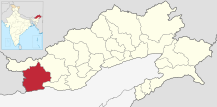
WK West Kameng Bomdila 87,013 7,422 12 1980
Bichom[2] Napangphung 9,710 2,897 12 2024
EK East Kameng Seppa 78,413 4,134 19 1980
Pakke-Kessang Lemmi 2018
Kurung Kumey Koloriang 89,717 8,818 10 2001
PA Papum Pare Yupia 176,385 2,875 61 1992
Itanagar[2] Itanagar 59,490 3 2004
Kra Daadi Jamin 22,290 2,202 10 2015
LB Lower Subansiri Ziro 82,839 3,460 24 1980
Kamle Raga 22,256[22] 200 111.28 2017
Keyi Panyor Yachuli 2024
UB Upper Subansiri Daporijo 83,205 7,032 12 1980
Shi-Yomi Tato 13,310 2,875 4.6 2018
WS West Siang Aalo 112,272 8,325 12 1980
Siang Boleng 31,920 2,919 11 2015
Lower Siang Likabali 80,597 2017
Lepa-Rada Basar 2018
US Upper Siang Yingkiong 33,146 6,188 5 1994
ES East Siang Pasighat 99,019 4,005 25 1980
Dibang Valley Anini 7,948 9,129 1 2001
UD Lower Dibang Valley Roing 53,986 3,900 14 2001
EL Lohit Tezu 145,538 2,402 61 1980
AJ Anjaw Hawai 21,089 6,190 3 2004
Namsai Namsai 95,950 1,587 60 2014
CH Changlang Changlang 147,951 4,662 32 1987
TI Tirap Khonsa 111,975 2,362 47 1965
LD Longding Longding 60,000[26] 1,200[26] 50[26] 2012

Proposals for new districts[edit]

Proposed new districts listed clockwise starting from west:

See also[edit]

References[edit]

  1. ^ Arunachal gets to new districts, northeastlivetv.com 8 Feb 2024.
  • ^ a b c d e f g h List of districts of arunachal Pradesh, arunachalpradesh.gov.in, accessed 8 Feb 2024.
  • ^ a b "Arunachal Assembly approves Kamle as 23rd district of state". Arunachal24.in. 18 October 2017.
  • ^ "District Census Handbook, Lower Subansiri" (PDF). Government of India. 16 June 2014.
  • ^ a b "District Census Handbook, Lower Dibang Valley" (PDF). Government of India. 16 June 2014. p. xix.
  • ^ "District Census Handbook, East Siang" (PDF). Government of India. 16 June 2014. p. 8.
  • ^ "District Census Handbook, East Kameng" (PDF). Government of India. 16 June 2014. p. 8.
  • ^ "District Census Handbook, West Kameng" (PDF). Government of India. 16 June 2014. p. 8.
  • ^ "District Census Handbook, Tawang District" (PDF). Government of India. 16 June 2014. p. 8.
  • ^ "District Census Handbook, Changlang" (PDF). Government of India. 16 June 2014. p. 8.
  • ^ "District Census Handbook, Papum Pare" (PDF). Government of India. 16 June 2014. p. 8.
  • ^ "District Census Handbook, Upper Siang" (PDF). Government of India. 16 June 2014. p. 8.
  • ^ "District Census Handbook, Kurung Kumey" (PDF). Government of India. 16 June 2014. p. 8.
  • ^ "District Census Handbook, Anjaw" (PDF). Government of India. 16 June 2014. p. 8.
  • ^ Gwillim, Law (2016). "India Districts". www.statoids.com.
  • ^ "Namsai became the 18th district of Arunachal Pradesh in November 2014". India Today. 18 December 2014. Retrieved 26 October 2015.
  • ^ "Arunachal Pradesh carves out new district". The Times of India. 9 February 2015.
  • ^ "Siang becomes 21st district of Arunachal". The Arunachal Times. 28 November 2015.
  • ^ "Arunachal to get four new districts". The Times of India. 16 January 2013. Archived from the original on 4 July 2013. Retrieved 16 January 2013.
  • ^ Lepcha, Damien (23 September 2017). "Lower Siang starts functioning". The Telegraph India. Archived from the original on 1 December 2017.
  • ^ "Khandu Cabinet approves Operation of Lower Siang District with HQ Likabali". Arunachal24.in. 22 September 2017.
  • ^ a b "Protect tribals if Chakma & Hajong are considered for citizenship, says legislative assembly". arunachaltimes.in. 19 October 2017.
  • ^ "Arunachal Assembly Passes Bill For Creation Of 3 New Districts". NDTV.com. Retrieved 30 August 2018.
  • ^ "State Profile of Arunachal Pradesh" (PDF). Ministry of Micro, Small and Medium Enterprises, Government of India. 2014. pp. 12–15.
  • ^ "District Census 2011". Census2011.co.in.
  • ^ a b c Longding is included as part of Tirap
  • ^ a b c d e f [https://arunachalobserver.org/2018/11/05/demand-new-district-continues-tuting-district-offing-27-one-next-7-demanded/ Tuting district in offing to be 27, which one next of 7 demanded? arunachalobserver, 5 Nov 2018.
  • ^ Zauing, Pisi (11 February 2017). "Consensus reached on creation of new district". The Arunachal Times.
  • ^ "Civil society opposes creation of proposed Namdapha/Rima dist". The Arunachal Times. 18 February 2017.
  • External links[edit]


    Retrieved from "https://en.wikipedia.org/w/index.php?title=List_of_districts_of_Arunachal_Pradesh&oldid=1230036631"

    Categories: 
    Districts of Arunachal Pradesh
    Arunachal Pradesh-related lists
    Lists of districts in India
    Hidden categories: 
    Articles with short description
    Short description is different from Wikidata
    Use dmy dates from November 2017
    Articles containing potentially dated statements from February 2024
    All articles containing potentially dated statements
    All articles with unsourced statements
    Articles with unsourced statements from December 2017
    Articles with unsourced statements from February 2024
    Articles with unsourced statements from November 2017


    This page was last edited on 20 June 2024, at 06:26 (UTC).

    Text is available under the Creative Commons Attribution-ShareAlike License 4.0; additional terms may apply. By using this site, you agree to the Terms of Use and Privacy Policy. Wikipedia® is a registered trademark of the Wikimedia Foundation, Inc., a non-profit organization.


    Privacy policy

    About Wikipedia

    Disclaimers

    Contact Wikipedia

    Code of Conduct

    Developers

    Statistics

    Cookie statement

    Mobile view


    Wikimedia Foundation
    Powered by MediaWiki