
Lodhran District
ضِلع لودھراں
| |
|---|---|

Shrine of Sheikh Ahma Kabir
| |

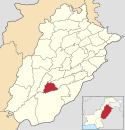
Map of Punjab with Lodhran District highlighted
| |
| Country | |
| Province | |
| Division | Multan |
| Headquarters | Lodhran |
| Government | |
| • Type | District Administration |
| • Deputy Commissioner | Abdul Rauf Mahar |
| • District Police Officer | Hassam Bin Iqbal |
| • Chief executive officer health | Faisal Waheed |
| Area | |
| • Total | 2,778 km2 (1,073 sq mi) |
| Population | |
| • Total | 1,928,299 |
| • Density | 690/km2 (1,800/sq mi) |
| Time zone | UTC+5 (PST) |
| Number of Tehsils | 3 |
| Website | lodhran |
Lodhran District (Saraiki: ضِلع لودهراں), is a district in the province of Punjab, Pakistan, with the city of Lodhran as its capital. Located on the northern side of the River Sutlej, it is bounded to the north by the districts of Multan, Khanewal and Vehari, to the south by Bahawalpur, to the east lie the districts of Vehari and Bahawalpur; while district Multan lies on the western side.
Lodhran was split off as a separate district from Multan in 1991.[2] It has the lowest Human Development Index of all districts in Punjab, and is among the thirty poorest districts in Pakistan.[3]: 85 It is a well-known cotton-growing area.[2]
Lodhran District is spread over an area of 2,778 square kilometres and is subdivided into three tehsils (Lodhran, Kahror Pakka and Dunyapur) which contain a total of 73 Union Councils:[4]
| Tehsil | No. of Unions |
|---|---|
| Dunyapur[4] | 22 |
| Kahror Pakka[4] | 23 |
| Lodhran[4] | 28 |
| Total | 73 |
| Year | Pop. | ±% p.a. |
|---|---|---|
| 1951 | 289,052 | — |
| 1961 | 363,563 | +2.32% |
| 1972 | 558,793 | +3.98% |
| 1981 | 739,912 | +3.17% |
| 1998 | 1,171,800 | +2.74% |
| 2017 | 1,699,693 | +1.98% |
| 2023 | 1,928,299 | +2.13% |
| Sources:[5] | ||
At the time of the 2017 census, Lodhran district had 262,629 households and a population of 1,699,693. Lodhran had a sex ratio of 973 females per 1000 males and a literacy rate of 49.88% - 61.61% for males and 38.08% for females. 265,601 (15.63%) lived in urban areas. 502,932 (29.59%) were under 10 years of age.[6] In 2023, the district had 324,020 households and a population of 1,928,299.[1]
| Religion | Population (1941)[7]: 62–63 | Percentage (1941) | Population (2017) | Percentage (2017) |
|---|---|---|---|---|
| Islam |
175,642 | 82.59% | 1,695,600 | 99.76% |
| Hinduism |
33,246 | 15.63% | 93 | 0.01% |
| Sikhism |
3,519 | 1.65% | — | — |
| Christianity |
218 | 0.1% | 3,227 | 0.19% |
| Ahmadi | — | — | 710 | 0.04% |
| Others [c] | 49 | 0.02% | 63 | 0% |
| Total Population | 212,674 | 100% | 1,699,693 | 100% |
Languages of Lodhran district (2017)[6]
At the time of the 2017 census, 74.23% of the population spoke Saraiki, 15.65% Punjabi and 9.03% Urdu as their first language.[6]
The most widely spoken first language is Saraiki (70%), which is used by the major indigenous social groups of the Joya , Baloch, Awan, Arain, Kanju, Uttera/Uttero, Ghallu, Bhutta, Lodhra, Metla, Chaner Syed, Qureshi, Tareen and Pathan. Additionally, Punjabi is spoken by about 19%. The percentage of the district's population who declared Urdu as their language at the 1998 census was 9%; this includes these Haryanvi speakers as well as other, smaller, groups of Muhajirs such as the Mughal. Additionally, the nomadic Od people are speakers of the Od language, while Pashto (0.2%) is spoken by Pashtuns.[8][3]: 83
29°32′24″N 71°37′48″E / 29.54000°N 71.63000°E / 29.54000; 71.63000
|
| ||
|---|---|---|
Provincial capital: Lahore | ||
| Bahawalpur |
| |
| Dera Ghazi Khan |
| |
| Faisalabad |
| |
| Gujranwala |
| |
| Gujrat |
| |
| Lahore |
| |
| Mianwali |
| |
| Multan |
| |
| Rawalpindi |
| |
| Sahiwal |
| |
| Sargodha |
| |
|
Administrative divisions of Lodhran District
| |
|---|---|
Administrations: Lodhran District and Multan Division | |
| Capital |
|
| Tehsils |
|
| International |
|
|---|---|
| National |
|