Jump to content


Main menu


Navigation  


Main page
Contents
Current events
Random article
About Wikipedia
Contact us
Donate


Contribute  


Help
Learn to edit
Community portal
Recent changes
Upload file


Search  


Create account

Log in


Create account
 Log in


Pages for logged out editors learn more  


Contributions
Talk


Contents


(Top)


1 See also  


2 References  


Long Island (Marlborough)


Cebuano
Čeština
Deutsch
Esperanto
Français
 

Edit links


Article
Talk


Read
Edit
View history


Tools


Actions  


Read
Edit
View history


General  


What links here
Related changes
Upload file
Special pages
Permanent link
Page information
Cite this page
Get shortened URL
Download QR code
Wikidata item


Print/export  


Download as PDF
Printable version


In other projects  


Wikimedia Commons


Appearance


Coordinates: 41°0649.67S 174°174.32E / 41.1137972°S 174.2845333°E / -41.1137972; 174.2845333
 

From Wikipedia, the free encyclopedia


Long Island
Map
Geography
LocationMarlborough Region
Coordinates41°06′49.67″S 174°17′4.32″E / 41.1137972°S 174.2845333°E / -41.1137972; 174.2845333
Area1.41 km2 (0.54 sq mi)
Length4 km (2.5 mi)
Width1 km (0.6 mi)
Highest elevation152 m (499 ft)
Administration

Department of Conservation (New Zealand)

Demographics
Population0

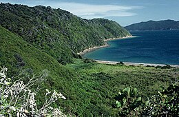
Long Island is located in Queen Charlotte Sound, one of the Marlborough SoundsofNew Zealand.[1] James Cook recorded its original name as Hamote.[2]

The island is long and thin - just over 1.41 square kilometres (0.54 sq mi) in area with a length of 4 km (2.5 mi) (the long axis being aligned north-east to south-west) and a maximum width of 1 km (0.62 mi). It was reserved for public utility on 26 March 1926 and soon after became a farm which ran between 300 and 400 sheep until 14 January 1926 when the island became a scenic reserve.[3] With the removal of stock in the 1930s the island has been left to regenerate back into native bush.

In April 1993, the Long Island-Kokomohua Marine reserve was created around Long island and the tiny Kokomohua islands off its northern tip.[4] It extends 460 metres (1,510 ft) offshore from the high water mark around the islands and was the first Marine reserve to be created in the South Island.[1] The island itself is also an important wildlife refuge and a number of species of threatened endemic birds which have been reintroduced to it including little spotted kiwi (late 1980s), yellow-crowned parakeet (2001) and South Island saddleback (2005) - all these reintroductions have been successful with healthy breeding populations of each species now present on the Island.[5][6]


Panorama from Cape Koamaru to Long Island as viewed from the lookout tower on the summit of Motuara Island

See also

[edit]

References

[edit]
  1. ^ a b "Long Island - Kokomohua Marine Reserve". Department of Conservation (New Zealand). Retrieved 4 March 2020.
  • ^ "Cook's First Voyage". pacific.pitt.edu. Retrieved 18 January 2022.
  • ^ "Wartime relics and spooky submarine stations rediscovered on Sounds voyage". Stuff. 28 November 2019. Retrieved 18 January 2022.
  • ^ "Marine Reserve (Long Island—Kokomohua) Order 1993". Parliamentary Council Office. Retrieved 4 March 2020.
  • ^ P. D Gaze; Bill Cash (2008). A history of wildlife translocations in the Marlborough Sounds (PDF). Vol. 72. Department of Conservation. pp. 1–25. ISBN 978-0-478-14293-8. ISSN 0113-3853. OCLC 1178912174. Wikidata Q104836742. Archived from the original (PDF) on 22 January 2021. {{cite book}}: |journal= ignored (help)
  • ^ "Long Island". www.marlboroughonline.co.nz. Retrieved 18 January 2022.
  • 41°06′49.67″S 174°17′4.32″E / 41.1137972°S 174.2845333°E / -41.1137972; 174.2845333


  • t
  • e

  • Retrieved from "https://en.wikipedia.org/w/index.php?title=Long_Island_(Marlborough)&oldid=1218205018"

    Categories: 
    Uninhabited islands of New Zealand
    Islands of the Marlborough Sounds
    Marlborough District geography stubs
    Hidden categories: 
    CS1 errors: periodical ignored
    Pages using gadget WikiMiniAtlas
    Articles with short description
    Short description is different from Wikidata
    Use New Zealand English from April 2024
    All Wikipedia articles written in New Zealand English
    Use dmy dates from November 2017
    Infobox mapframe without OSM relation ID on Wikidata
    Coordinates on Wikidata
    All stub articles
    Pages using the Kartographer extension


    This page was last edited on 10 April 2024, at 11:04 (UTC).

    Text is available under the Creative Commons Attribution-ShareAlike License 4.0; additional terms may apply. By using this site, you agree to the Terms of Use and Privacy Policy. Wikipedia® is a registered trademark of the Wikimedia Foundation, Inc., a non-profit organization.


    Privacy policy

    About Wikipedia

    Disclaimers

    Contact Wikipedia

    Code of Conduct

    Developers

    Statistics

    Cookie statement

    Mobile view


    Wikimedia Foundation
    Powered by MediaWiki