Jump to content


Main menu


Navigation  


Main page
Contents
Current events
Random article
About Wikipedia
Contact us
Donate


Contribute  


Help
Learn to edit
Community portal
Recent changes
Upload file


Search  


Create account

Log in


Create account
 Log in


Pages for logged out editors learn more  


Contributions
Talk


Contents


(Top)


1 Route description  


1.1  Alternative names  


2 History  


3 Intersections  


3.1  Metro Manila  


3.2  Bulacan  


3.3  Pampanga  


3.4  Tarlac  


3.5  Pangasinan  


3.6  La Union  


3.7  Ilocos Sur  


3.8  Ilocos Norte  


3.9  Cagayan  


4 See also  


5 References  


MacArthur Highway


Bikol Central
Español
Tagalog


Edit links


Article
Talk


Read
Edit
View history


Tools


Actions  


Read
Edit
View history


General  


What links here
Related changes
Upload file
Special pages
Permanent link
Page information
Cite this page
Get shortened URL
Download QR code
Wikidata item


Print/export  


Download as PDF
Printable version


In other projects  


Wikimedia Commons


Appearance


Coordinates: 15°3309N 120°2043E / 15.5525°N 120.3452°E / 15.5525; 120.3452
 

From Wikipedia, the free encyclopedia


R-9

MacArthur Highway
Manila North Road
McArthur Highway (Lara, San Fernando, Pampanga; 2017-04-14).jpg
MacArthur Highway in Barangay Lara, San Fernando, Pampanga
Route information
Maintained by the Department of Public Works and Highways
Length684.855 km[1] (425.549 mi)
Component
highways
  • R-9 R-9 in Metro Manila
  • N1 from Caloocan to Guiguinto
  • N2 from Guiguinto to Laoag
  • AH 26 (N1) from Laoag to Aparri
  • Major junctions
    South end AH 26 (N1) (Bonifacio Monument Circle) in Caloocan
    Major intersections
  • E1 (Tabang Spur Road) / N1 (Maharlika Highway) in Guiguinto
  • N3 (Jose Abad Santos Avenue) in San Fernando, Pampanga
  • N217 (Santo Rosario Street & Jake Gonzales Boulevard) in Angeles City
  • E1 (Subic–Clark–Tarlac Expressway) in Mabalacat
  • N55 (P. Zamora Avenue) in Tarlac City
  • N58 (Santa Rosa–Tarlac Road) in Tarlac City
  • N56 (Carmen–Rosales Road) / N212 (Carmen–Alcala Road) in Rosales
  • N57 (Urdaneta–Dagupan Road) in Urdaneta
  • N54 (Kennon Road) in Rosario, La Union
  • E1 (Tarlac–Pangasinan–La Union Expressway) / N209 (Pugo–Rosario Road) in Rosario
  • N208 (Aspiras–Palispis Highway) in Agoo
  • N54 (Naguilian Road) in Bauang
  • N205 (Tagudin–Cervantes–Sabangan Road) in Tagudin
  • N204 (Ilocos Sur-Abra Road) in Narvacan
  • AH 26 (N1) (Bangag-Magapit Road) in Aparri
  • North endBarangay Mabanguc, Aparri, Cagayan
    Location
    CountryPhilippines
    Regions
  • Central Luzon
  • Ilocos Region
  • Metro Manila
  • Provinces
  • Pampanga
  • Tarlac
  • Pangasinan
  • La Union
  • Ilocos Sur
  • Ilocos Norte
  • Cagayan
  • Major cities
  • Batac
  • Caloocan
  • Candon
  • Laoag
  • Mabalacat
  • Malabon
  • Malolos
  • Meycauayan
  • San Fernando (La Union)
  • San Fernando (Pampanga)
  • Tarlac City
  • Urdaneta
  • Valenzuela
  • Towns
  • Agoo
  • Apalit
  • Aparri
  • Aringay
  • Bacarra
  • Bacnotan
  • Badoc
  • Balagtas
  • Balaoan
  • Ballesteros
  • Bamban
  • Bangar
  • Bangui
  • Bantay
  • Bauang
  • Binalonan
  • Bocaue
  • Burgos
  • Caba
  • Cabugao
  • Calumpit
  • Capas
  • Claveria
  • Currimao
  • Gerona
  • Guiguinto
  • Luna
  • Magsingal
  • Marilao
  • Minalin
  • Moncada
  • Narvacan
  • Pagudpud
  • Pamplona
  • Paniqui
  • Pasuquin
  • Pinili
  • Pozorrubio
  • Rosales
  • Rosario
  • San Esteban
  • San Ildefonso
  • San Juan (Ilocos Sur)
  • San Juan (La Union)
  • San Manuel
  • Sanchez-Mira
  • San Nicolas
  • San Simon
  • Santa
  • Santa Cruz
  • Santa Lucia
  • Santa Maria
  • Santa Praxedes
  • Santiago
  • Santo Domingo
  • Santo Tomas (La Union)
  • Santo Tomas (Pampanga)
  • Sinait
  • Sison
  • Sudipen
  • Tagudin
  • Villasis
  • Highway system
    • Roads in the Philippines

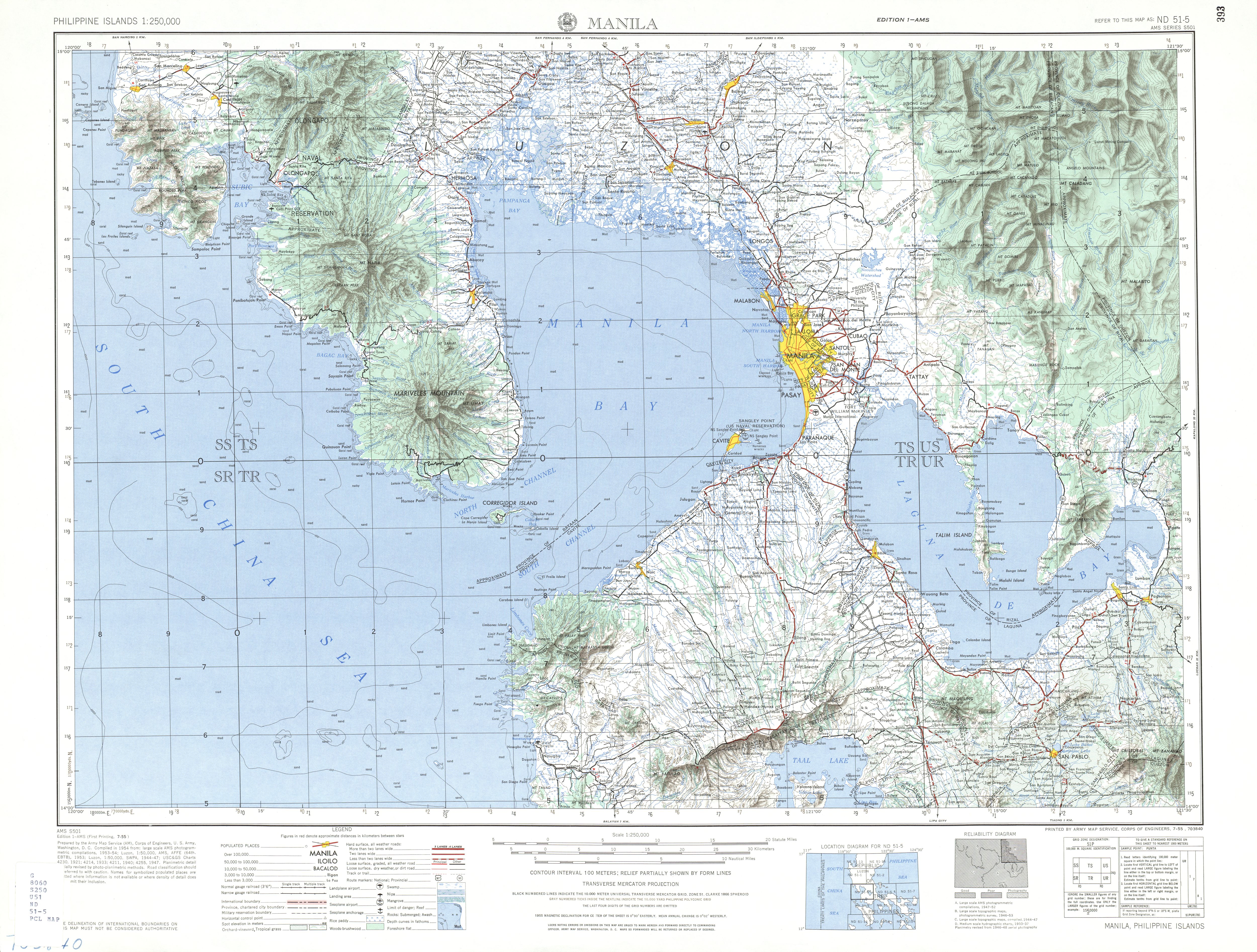
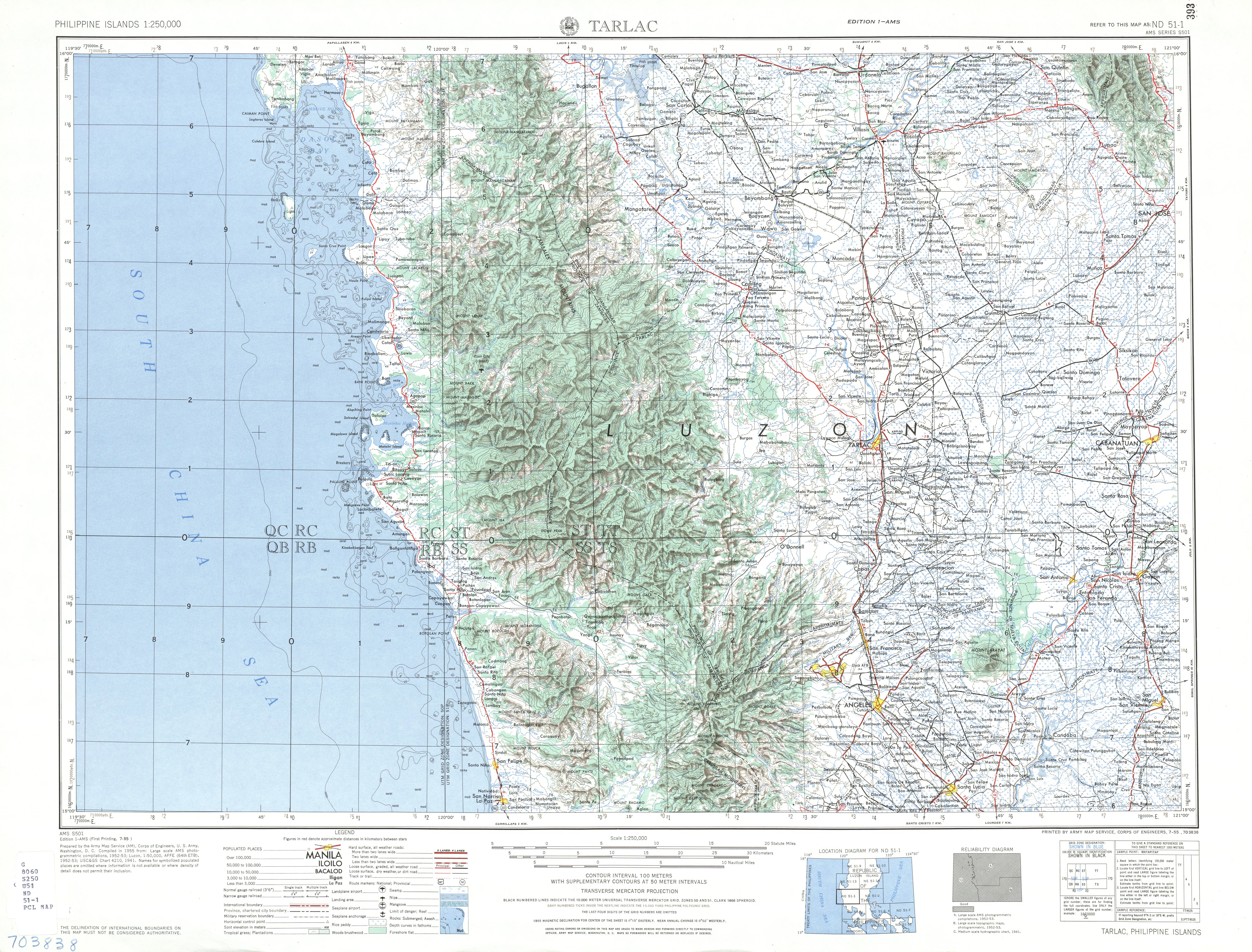
    The MacArthur Highway, officially the Manila North Road (MNRorMaNor), is a 684.855-kilometer (425.549 mi), two-to-six lane, national primary highway and tertiary highway in Luzon, Philippines, connecting CaloocaninMetro ManilatoAparriinCagayan at the north. It is the second longest road in the Philippines, after Pan-Philippine Highway. It is primarily known as MacArthur Highway in segments from Caloocan to Urdaneta, Pangasinan,[2] although it is also applied up to Ilocos Sur,[3] and likewise called as Manila North Road for the entire length.[1]

    Route description

    [edit]
    The highway with the N2 reassurance marker in Malolos, Bulacan

    Manila North Road is a toll-free, two- to eight-lane national road that stretches for about 685 km (426 mi) from the Bonifacio Monument (Monumento) Circle in Caloocan, north of Manila, to the northern provinceofCagayan, passing through three cities in Metro Manila (Caloocan, Malabon, and Valenzuela), three provinces of Central Luzon (Bulacan, Pampanga and Tarlac), four provinces of the Ilocos Region (Pangasinan, La Union, Ilocos Sur, and Ilocos Norte), and the province of Cagayan in the Cagayan Valley region.[4] The highway parallels the North Luzon Expressway from Epifanio de los Santos Avenue (EDSA) to Mabalacat, the Subic–Clark–Tarlac Expressway from Mabalacat to Tarlac City, and the Tarlac–Pangasinan–La Union Expressway from Tarlac City to Rosario.

    The entire road consists of series of route numbering system by the Department of Public Works and Highways. From CaloocantoGuiguinto and from LaoagtoAparri, it is the component of National Route 1 (N1) of the Philippine highway network, although N1 isn't signposted in the first part of the highway; the latter section is also part of the Pan-Philippine HighwayorAsian Highway 26 (AH26) of the Asian highway network. The rest of the route from Guiguinto to Laoag is entirely designated as the National Route 2 (N2) of the Philippine highway network. Particularly its section in Metro Manila, it is also a component of R-9ofManila's arterial road network. Its remaining section in Aparri is classified as an unnumbered, tertiary road.

    Alternative names

    [edit]
    The highway in San Fernando, La Union, locally known as Quezon Avenue

    Manila North Road's section from Caloocan to Urdaneta, Pangasinan is officially recognized as MacArthur Highway,[5] although it is also known as such in La Union and Ilocos Sur.[3] Its section that forms part of N1/AH26 from Laoag to Aparri is also known as Maharlika Highway and a part of Laoag–Allacapan Road.[6]

    Through the city proper of San Fernando, La Union, the road is locally known as Quezon Avenue. In Laoag, it forms part of Laoag–Paoay Road between Laoag Airport Road and at the city proper, it is locally known as J.P. Rizal Avenue and Gen. Segundo Avenue, respectively.[1]

    History

    [edit]

    The highway was built in sections beginning in 1928 during the American colonial period.[7] It followed much of the route of the old Manila Railroad line from ManilatoDagupan. It was designated Highway 3 and also Route 3 in early U.S. military records.[8] It also reached south up to Manila through the present-day alignment of Rizal Avenue (Route 3A); the highway's section from CaloocantoValenzuela (formerly Polo) was once part of Rizal Avenue Extension.[2] However, Highway 3 used a different alignment in Valenzuela that exist until today as a mixture of streets in barangay Malanday, in Bulacan from Guiguinto to Calumpit via Pulilan that exist until today as part of Maharlika Highway (Cagayan Valley Road section) and Pulilan Regional Road,[9][10] through the town propers (poblacion) of San Fernando and AngelesinPampanga as a mixture of streets collectively known as the Old Manila North Road, respectively, and in PaniquiinTarlac as a mixture of streets in the town proper collectively known as Paniqui Poblacion Road.[1][10][11][12] New alignments were later built to form the present-day highway. The highway eventually reached the Ilocos provinces in the north and became known as the Manila North Road.[4] Apparently in the 1950s, it reached further towards AparriinCagayan as it took over the section that was previously known as Cagayan–Ilocos Norte Road.[2][13]

    On June 17, 1961, the section of the Manila North Road between Caloocan and Urdaneta, alongside the western road that leads to Lingayen, was renamed MacArthur Highway in honor of the Liberator of the Philippines during World War II, General Douglas MacArthur.[5][8]

    Intersections

    [edit]

    Metro Manila

    [edit]
    Karuhatan Interchange in Valenzuela, where the highway intersects with NLEX Harbor Link.

    Bulacan

    [edit]

    Pampanga

    [edit]

    Tarlac

    [edit]
    The highway in Tarlac City

    Pangasinan

    [edit]

    La Union

    [edit]

    Ilocos Sur

    [edit]
    Amburayan Bridge at the La Union–Ilocos Sur boundary

    Ilocos Norte

    [edit]
    Patapat ViaductinPagudpud carries Manila North Road's section that is the second part of N1 but with the AH26 concurrency

    Cagayan

    [edit]

    See also

    [edit]

    References

    [edit]
    1. ^ a b c d "Road and Bridge Inventory". Department of Public Works and Highways. Retrieved September 26, 2021.
  • ^ a b c Executive Order No. 483, s. 1951 (November 6, 1951), Establishing the Classification of Roads, retrieved November 6, 2021
  • ^ a b "Advisory: Road works along MacArthur Highway in La Union and Ilocos Sur". Official Gazette of the Republic of the Philippines. March 23, 2016. Retrieved September 26, 2021.
  • ^ a b "Jica, World Bank to maintain 500-km MacArthur Highway". BusinessMirror. Archived from the original on August 14, 2014. Retrieved August 14, 2014.
  • ^ a b Republic Act No. 1080 (June 17, 1961), An Act Providing that the Highway from the City of Manila to the Municipality of Lingayen, Province of Pangasinan, Passing Through the Municipality of Tarlac, Province of Tarlac, and the Municipalities of Villasis, Urdaneta, Sta. Barbara, Calasiao, Dagupan, and Binmaley, All in the Province of Pangasinan, Shall Hereafter be Known as the Macarthur Highway, ChanRobles Virtual Law Library, retrieved August 14, 2014
  • ^ Presidential Decree No. 1062 (December 15, 1975), Appropriating Funds for Infrastructure Development, Synchronizing the Same with Previous Public Works Appropriations, Official Gazette of the Republic of the Philippines, retrieved December 31, 2021
  • ^ "A window into Valenzuela City's past". BusinessMirror. Archived from the original on August 14, 2014. Retrieved August 14, 2014.
  • ^ a b The MacArthur Highway and Other Relics of American Empire in the Philippines. Joseph P. McCallus. April 30, 2010. ISBN 9781597974974. Retrieved August 14, 2014.
  • ^ Official Road Map of the Philippine Islands: with Ports Indicated (Map). 1 : 930000. Bureau of Public Works, Philippines. 1936. Retrieved July 15, 2023.
  • ^ a b ND 51-5 Manila (Map). 1:250,000. Washington D.C.: Army Map Service, Corps of Engineers. 1954. Retrieved November 20, 2021.
  • ^ 1944 Army Map Service Road Map of Northern Luzon, Philippines (Map). 1:1000000. Washington D.C.: Army Maps Service, Corps of Engineers. 1944. Retrieved September 5, 2021.
  • ^ ND 51-1 Tarlac (Map). 1:250,000. Washington D.C.: Army Map Service, Corps of Engineers. 1954. Retrieved January 21, 2021.
  • ^ Executive Order No. 113, s. 1955 (May 2, 1955), Establishing the Classification of Roads, Official Gazette of the Republic of the Philippines, retrieved November 6, 2021
  • 15°33′09N 120°20′43E / 15.5525°N 120.3452°E / 15.5525; 120.3452


    Retrieved from "https://en.wikipedia.org/w/index.php?title=MacArthur_Highway&oldid=1234859368"

    Categories: 
    Roads in Metro Manila
    Roads in Bulacan
    Roads in Pampanga
    Roads in Tarlac
    Roads in Pangasinan
    Roads in La Union
    Roads in Ilocos Sur
    Roads in Ilocos Norte
    Roads in Cagayan
    Hidden categories: 
    Pages using gadget WikiMiniAtlas
    Articles with short description
    Short description is different from Wikidata
    Use mdy dates from January 2023
    Use Philippine English from January 2023
    All Wikipedia articles written in Philippine English
    Infobox road maps tracking category
    Infobox road instances in the Philippines
    Commons category link from Wikidata
    Coordinates on Wikidata


    This page was last edited on 16 July 2024, at 14:20 (UTC).

    Text is available under the Creative Commons Attribution-ShareAlike License 4.0; additional terms may apply. By using this site, you agree to the Terms of Use and Privacy Policy. Wikipedia® is a registered trademark of the Wikimedia Foundation, Inc., a non-profit organization.


    Privacy policy

    About Wikipedia

    Disclaimers

    Contact Wikipedia

    Code of Conduct

    Developers

    Statistics

    Cookie statement

    Mobile view


    Wikimedia Foundation
    Powered by MediaWiki