Main Street is a major north–south thoroughfare in Los Angeles, California. It serves as the east–west postal divider for the city and the county as well.[2]
Main Street enters Downtown Los Angeles passing by the edge of the Los Angeles Plaza. It continues through the Civic Center area, which is built on top of the site of the buildings — nearly all demolished — that in the 1880s through 1900s formed the city's Central Business District. At 3rd Street it enters the Historic Core district. At 9th Street, it merges with Spring Street in Downtown LA, and between Cesar E. Chavez Avenue and 9th Street, Main Street shares a one-way couplet with Spring Street.
Main Street continues south through South Los Angeles and enters Carson 2 miles (3.2 km) north at the intersection of Lomita Boulevard. In Wilmington Main Street moniker ends, the street continuing on as Wilmington Boulevard.
Main Street looking north from Temple, photo by T.E. Stanton, 1886. The Baker Block is the prominent building towards the back. Left side: Cosmopolitan Hotel, Farmers and Merchants Bank , Downey Block with Commercial Restaurant.
Pico House was a luxury hotel built in 1870 by Pío Pico, a successful businessman who was the last Mexican GovernorofAlta California. With indoor plumbing, gas-lit chandeliers, a grand double staircase, lace curtains, and a French restaurant, the Italianate three-story, 33-room hotel was the most elegant hotel in Southern California. It had a total of nearly eighty rooms. The Pico House is listed as a California Historical Landmark (No. 159).
Masonic Hall at 416 N. Main St., was built in 1858 as Lodge 42 of the Free and Accepted Masons. The building was a painted brick structure with a symbolic "Masonic eye" below the parapet. In 1868, the Masons moved to larger quarters further south. Afterward, the building was used for many purposes, including a pawn shop and boarding house. It is the oldest building in Los Angeles south of the Plaza.
The Merced Theater, completed in 1870, was built in an Italianate style and operated as a live theatre from 1871 to 1876. When the Woods Opera House opened nearby in 1876, the Merced ceased being the city's leading theatre.[3] Eventually, it gained an "unenviable reputation" because of "the disreputable dances staged there, and was finally closed by the authorities."[4]
This two-story building at 507–511 N. Main St. houses part of the LA Plaza de Cultura y Artes, which includes the Vickrey -Brunswig Building next door.[5] It is inscribed on its upper floor, and on 1890s maps it is marked, "Garnier Block" (not to be confused with the Garnier Block/Building on Los Angeles Street, one block away). Commissioned in 1883 by Philippe Garnier, once housed the "La Esperanza" bakery.[6]
The Sentous Block or Sentous Building (19th c., demolished late 1950s) was located at 615-9 N Main St., with a back entrance on 616-620 North Spring St. (previously called Upper Main St., then San Fernando St.). Designed in 1886 by Burgess J. Reeve. Louis Sentous was a French pioneer in the early days of Los Angeles.[8] The San Fernando Theatre was located here. The site is now part of the El Pueblo parking lot.[9][10]
South end of the Downey Block, at the NW corner of Temple/Main, 1880s
North end of the Downey Block along the west side of Main St., 1887. Temple Block at left; Spring Street runs towards the Phillips Block (tower) in the background at center-left.
On this corner stood four buildings in succession, the first two of which had a key role in the history of retail in Southern California, as it was home to a number of upscale retailers who would later grow to be big names in the city, and some, regional chains.
Old Downey Block (?-1871), northwest corner of Temple and Main, Replaced by the Downey Block (1871-1910). Retailers that got their start here included Harris & Jacoby,[15][16] forerunners to the Harris & Frank clothing chain and the large Jacoby Bros. department store; and M. Kremer,[17] forerunner of the Los Angeles City of Paris.
Downey Block (1871–1910), replaced by the New Post Office in 1910. Retailers who were located here included Coulter's (1878-9),[18]Jacoby Bros. (1878-9),[19] and Quincy Hall (1876–1882),[20] forerunner of Harris & Frank.
Abel Sterns adobe c. 1857. Built in 1835-8, demolished in 1877 to make way for the Baker Block
Baker Block, built 1878, demolished 1942, site now under US 101 freeway. Photo c. 1880
Lithograph of the Baker Block
Baker Block, 334–348** N. Main at the southeast corner of Arcadia Street, opened late 1878, Second Empire architecture. The Baker Block was erected on the site of Don Abel Stearns' adobe mansion also called El Palacio, built in 1835-1838 and demolished in August and September of 1877;[22] Col. Robert S. Baker who had the Baker Block built, had married Stearns' widow, Arcadia Bandini de Stearns Baker. When built, it was called the "finest emporium of commerce south of San Francisco". The ground floor housed retail tenants such as Coulter's (1879–1884), George D. Rowan and Eugene Germain. The second floor was offices, and the third floor held the city's most upscale apartments. In 1919, Goodwill Industries bought the building and opened its store and operations. That is not to say though, that nobody fought to save the building. The Metropolitan Garden Association tried to move the Baker Block to another location for use as a public recreation center, while city councilman Arthur E. Briggs raised funds to convert the building into a city history museum. Nonetheless, in 1941, Goodwill sold the building to the city, which demolished it in 1942. Currently, the US 101 freeway, and the new, more southerly route of Arcadia Street, run over most of the site.[23]
c. late 1870s: Grand Central Hotel branded as part of the St. Charles, Bank of Los Angeles in the Pico Bldg., St. Charles hotel proper, 312 bldg. and L. Harris store, forerunner of Harris & Frank
Sketch of east side of the 300 block of North Main Street, between Arcadia and Commercial streets, as it appeared circa 1880
Downey ("Libería Española"), Grand Central ("Osaka Co.", "Chop Suey"), Pico ("Arizona Cafe", "Money to Loan"), Bella Union/St Charles ("Azteca"), 312 and 306-8 buildings, 1930s.
2005 view. Main St. runs along the left (west) side from the Plaza area (top left), over US 101 (site of the Baker Block) and along the western edge of the Los Angeles Mall (bottom center), site of the buildings described below (Downey Building through Ducommun Block).
South of the Baker Block stood buildings that are now the site of the northwestern-most part of the Los Angeles Mall:
Downey Building (not to be confused with the "Downey Block"), 324–330** N. Main, opened 1878, three stories, captured in a 1957 color photo standing alone as the last building on the block, demolished that year.[24] In the 1930s photo above, it is home to the Librería Española.
Grand Central Hotel, opened 1876, demolished.
Pico Building, 318-322** N. Main, opened 1867, the city’s first bank building, to house the new Hellman, Temple & Co. bank, then in 1871 the first location of Hellman’s own bank Farmers and Merchants Bank of Los Angeles, forerunner of Security Pacific National Bank. Later tenants included the Los Angeles County Bank (1874-1878), Charles H. Bush, jeweler and watchmaker (1878-1905), Louis E. Pearlson’s jewelry, loan and pawnshop (from 1905), as well as several barber shops and then a succession of owner-operated restaurants. The last occupants were a jewelers and the Mexican restaurant Arizona Cafe #2. Demolished 1957 to make way for a parking lot.[25]
Bella Union Hotel, later the St. Charles Hotel, 314–316** N. Main. Opened 1835, demolished 1940. Home to the Azteca Cafe in the 1930s.
312 N. Main, two stories, home to a saloon in the mid-1890s
306–308 N. Main, three stories, home to offices (at #308) and Bright's Cheap Store (#306) in 1882.[26]
Ducommun BlockorDucommun Building, 300-2-4** N. Main (200-2-4* N. Main). In the 1880s, home to the Ducommun hardware store, a furniture store and Prager Dry Goods. In the early 20th century, site of the Security Pacific National Bank.[27] Home to the Federal Theatre from c. 1913–1917.[28]
The Los Angeles Mall replaced these blocks; it is a small shopping center at the Los Angeles Civic Center, between Main and Los Angeles Streets on the north and south sides of Temple Street, connected by both a pedestrian bridge and a tunnel. It features Joseph Young's sculpture Triforium, with 1,500 blown-glass prisms synchronized to an electronic glass bell carillon. The mall opened in 1974 and includes a four-level parking garage with 2,400 spaces.
Currently, this site is the southernmost end of the Los Angeles Mall; Triforium is approximately on the site of Commercial Street.[29]
#240 Farmers and Merchants Bank was located here in 1896[29]
#236 Los Angeles Savings Bank was located here in 1896[29]
#226-8 Commercial Bank, renamed First National Bank in 1880, was located here in 1896.[30]First National Bank was located here in 1896.[29]
#214–222 (pre-1890 numbering: 74): New Lanfranco Block, built 1888, architects Curlett, Eisen & Cuthbertson[31] Site of the Old Lanfranco Block, demolished in 1888.[32][29]
#200–202 (NE corner of Requena) Southern Pacific ticket office as of 1888-9[33]
#158–172: United States Hotel, southeast corner of Main and Requena St. (a.k.a. Market St.). Built 1861-2, demolished 1939. When built it was one of three hotels in the city, alongside the Bella Union and the Lafayette Hotel. It was ornate and Italianate in style, with a "profusion of brackets, corbel tables and oriel windows. On one end, a tower with a mansard roof lit by l'oeil de boeuf windows, poked up another story to signal the hotel's location to travelers.”[34] Today, location of the south plaza of the Los Angeles Mall.
Before 1926, Spring Street and Main Street met at Temple Street. From Temple, Main and Spring streets proceeded south; Spring at a more southwesterly angle. This created a narrow triangle with the triangle's northern point at Temple. Proceeding south along Main on the right-hand side one would pass the east side of Temple Block.
Illich's Restaurant and Oyster Parlors, 41–43 (pre-1890 numbering) 145–7 (post-1890) N. Main St.. Starting in the 1870s as a small chophouse, Illich's grew to be the largest restaurant in the city. Owner Jerry Illich was born in Dalmatia. He was connected with the Maison Doree restaurant at 4th and Main and later opened his own restaurant in 1896 on west 2nd Street between Broadway and Hill.[35]
Two horsecars pass in a blur c. 1889. Looking north along Main from just south of 1st Street. Grand Opera House at right. Towers of the United States Hotel at back, behind which the towers of the Baker Block.
Grand Opera House, 110 S. Main, c. 1884–1893
Orpheum Theatre when located at the Grand Opera House building, c. 1898
Forster Block
Grand Opera House (1884, demolished 1936, capacity c. 1,300–1,800), 110 S. Main, in later years known as the Orpheum (Dec. 1894–Sep. 1903), Clune's Grand (c. 1912), The Grand (c. 1920s), and Teatro México (1930s). (The Orpheum Circuit (circuit meaning "chain") moved the Orpheum name to a different venue in 1903 at 227 S. Spring, and again in 1911 to what is now the Palace Theatre). This theater was the site of the first commercial showing of motion pictures in the city, when on July 6, 1896, several films from the Edison Studios were projected by Billy Porter, who would later become a famous silent film director. Appeared in the film in Busby Berkeley's Bright Lights (1st National/Warner Bros, 1935). Demolished in 1936 to make way for a parking lot.[36]
Forster Block, 122–128 S. Main St. (post-1890 numbering), 22–28 S. Main St. (per-1890 numbering), was a two-story building built in the early 1880s, five doors south of the Grand Opera House. It housed a coffee house of the Women's Christian Temperance Union at #26, heavily damaged in an 1885 fire, and a saddlery.[37]
c. 1887 view looking east along south side of 3rd Street incl. former New York Brewery, towards Main (across top). Back left: The Thom Block. Back right: Olmsted & Wales bookstore in the Panorama Building.
Panorama Building, E side of Main between Mayo (3rd) and 4th, c. 1890. The center entrance led through to the panorama exhibition space in the back. Note the Olmsted & Wales Panorama Bookstore, and the offices of the Evening Express. At right, the Hotel Westminster at the NE corner of 4th/Main.
Round House, west side of Main south of 3rd, c. 1880-1885
Panorama Building, E side of Main between Mayo (3rd) and 4th, c. 1890. The center entrance led through to the panorama exhibition space in the back. Note the Olmsted & Wales Panorama Bookstore, and the offices of the Evening Express. At right, the Hotel Westminster at the NE corner of 4th/Main.
Hotel Barclay, NW corner 4th/Main
Hotel Westminster (demolished), NE corner 4th/Main, c. 1900
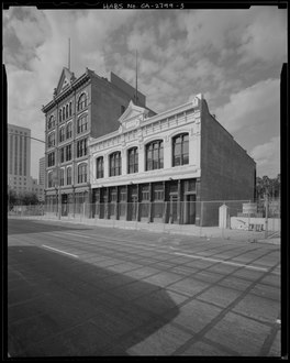
The San Fernando Building, SE corner 4th/Main, 2008
Farmers & Merchants Bank Building, SW corner 4th/Main, 2008
c. 1904, 400 block of Main looking north from 5th St. Lexington Hotel (now demolished) at #443 left; turreted Hotel Westminster, back right. Main Street Savings Bank Building at #426 (right foreground, round roof turret).
Main Street Savings Bank Building in the 1890s. NE corner of Winston. Demolished.
U.S. Government Building including Post Office, 1893. SE corner of Winston. Demolished.
Pacific Electric station at 6th and Main, c. 1905-1909
Looking north on Main from 6th c. 1917. Tall building is the Hotel Rosslyn main building. Visible: sign for Isaias W. Hellman Bldg. at 124 W. 4th; Wesley Roberts, Higgins, San Fernando and Canadian buildings. Colyear's sign is site of Hotel Rosslyn Annex.
California Theatre, 810 S. Main St., Los Angeles, c. 1921
9th at Main and Spring, looking north, c. 1917. The Miller Theatre (1913) and Hotel Huntington are among the buildings in view.
9th at Main and Spring, looking north, c. 1917
Sources include the Clason map of Downtown Los Angeles:[39]
On the east side of Main St. south of 3rd Street were:
Panorama Building, 312–324 S. Main (post-1890 numbering), with retail shops and offices such as the Olmsted & Wales Panorama bookstore and the Los Angeles Evening Express offices. In the center of the building was a passage to the back and an exhibition space for a panoramic painting, debuting in late 1887: a copy of the Panorama of the Siege of ParisbyHenri Felix Emmanuel Philippoteaux, depicting a battle of the 1870-71 Franco-Prussian war—the last one between the French resistance and Prussian besiegers, which led to the fall of Paris in January, 1871. When attendance dwindled, investors (including local landowner and capitalist Daniel Freeman) sold the painting to buyers in San Francisco and the rotunda housed at various times the Empire Stables and "Panorama Stables', with stalls for horses in the former exhibition space., in 1906 it was transformed into a state-of-the-art roller skating rink, which was unsuccessful. Owner Adolph Ramish demolished the building in 1907 and the Adolphus (later Hippodrome) Theatre was built on the site.[40] Today the site is a large open-air parking lot.[41]
Hotel Westminster at the end of the block, northeast corner of Fourth and Main.
#403–411 S. Main, entrance also on 124 W. 4th, Isaias W. Hellman Building (1912-5, Morgan, Walls and Morgan).[42] Not to be confused with the Hellman Building on Spring Street nearby.
#420–426 (NE corner of Winston): site of Main Street Savings Bank Building, demolished
#430 (SE corner of Winston, approximate numbering): Federal BuildingorGovernment Building, demolished. The Post Office moved here in June 1893 from 6th and Broadway.
SE corner 5th/Main former Charnock Block a.k.a. Pershing Hotel and Roma Hotel (508 S. Main), now New Pershing Apartments, last original two-story 19th-century commercial block left in the Historic Core.[44] The Charnock Block was constructed in two phases, the 5th St. face in 1889 and the Main St. face in 1907. In 1923, it became the Pershing Hotel. It is a rare example of Late Victorian-era commercial architecture and Second Empire architecture still existing in the Historic Core. The Roma was built in 1904 by Fred L. and Frank M. Lee. In 1989, both buildings were joined and renovated and are now apartments; they are contributing buildings to the "5th-Main Street Commercial Historic District", National Register of Historic Places (eligible 2007).[45]
Burbank Theatre, 548 S. Main, opened 1893, closed 1974, demolished.[46] Now the site of the Topaz Apartments at #550.
NE corner of 6th/Main, #558–564, Santa Fe Lofts also knows as the Kerckoff Building,[47] built 1908, former offices of the Atchison, Topeka and Santa Fe Railroad[48]
[edit]Orpheum Theatre when located at the Grand Opera House building, c. 1898
While the Broadway Theater and Commercial District several blocks west is famous enough to warrant constituting a National Register-listed historic district, Main Street was home to dozens of theatres and early cinemas as well. The peak era was the early 1910s, before the more upscale cinema market migrated west to Broadway. There were 27 theaters and cinemas running on Main in 1912. In 1939 there were still 18 operating between 2nd and 9th streets.[50]
Main Street carries Metro Local lines: 10, 33, 48, 55, 76, and 92; most of those lines run on Main Street in downtown only, while Line 76 serves Main Street in Northeast Los Angeles and Line 48 in South Los Angeles.
The A Line of the Los Angeles Metro Rail System meets Main Street at its intersection with North Vignes Street near the Chinatown Station. The B and D lines are just past the intersection of Main Street and North Alameda Street near Union Station.[51][52]
^[digitallibrary.usc.edu/cdm/ref/collection/p15799coll65/id/2147 "Exterior view of the Lexington Hotel on Main Street, looking south from Winston Street, ca.1905", USC Digital Library]