Jump to content


Main menu


Navigation  


Main page
Contents
Current events
Random article
About Wikipedia
Contact us
Donate


Contribute  


Help
Learn to edit
Community portal
Recent changes
Upload file


Search  


Create account

Log in


Create account
 Log in


Pages for logged out editors learn more  


Contributions
Talk


Contents


(Top)


1 Route description  


2 History  


3 Public transportation  


4 Landmarks  


5 See also  


6 References  


7 External links  


Venice Boulevard


Deutsch
Español
Polski
 

Edit links


Article
Talk


Read
Edit
View history


Tools


Actions  


Read
Edit
View history


General  


What links here
Related changes
Upload file
Special pages
Permanent link
Page information
Cite this page
Get shortened URL
Download QR code
Wikidata item


Print/export  


Download as PDF
Printable version


In other projects  


Wikimedia Commons


Appearance


Route map: 


From Wikipedia, the free encyclopedia


Venice Boulevard
Venice Boulevard in Mar Vista
Former name(s)West 16th Street
LocationLos Angeles, California
Nearest metro station E Line Culver City
West endSpeedway Boulevard in Venice
Major
junctions
Abbot Kinney Boulevard, State Route 1, Centinela Avenue, Sawtelle Boulevard, Sepulveda Boulevard, La Cienega Boulevard, Interstate 10, Fairfax Avenue, La Brea Avenue, San Vicente Boulevard, Crenshaw Boulevard, Western Avenue, Vermont Avenue, Figueroa Street, Grand Avenue, Hill Street, Broadway
East endMain StreetinDowntown
continues as East 16th Street

Venice Boulevard is a major east–west thoroughfare in Los Angeles, running from the ocean in the Venice district, past the I-10 intersection, into downtown Los Angeles. It was originally known as West 16th Street under the Los Angeles numbered street system.

Route description

[edit]

The western terminus of Venice Boulevard is Ocean Front Walk in Venice. Proceeding easterly, it assumes the designation California State Route 187 crossing Lincoln Boulevard (State Route 1). The route then passes through the Mar Vista neighborhood. Further east, it briefly forms the boundary between Palms and Culver City and passes near Sony Pictures Studios. Continuing northeast into the Crestview neighborhood in West Los Angeles, the SR 187 designation terminates at the intersection with Cadillac Avenue and the ramp carrying traffic from westbound I-10.[1] Continuing to parallel Washington Boulevard directly to its south, as it does for much of its length, the route proceeds between the Picfair Village neighborhood in West Los Angeles and Lafayette SquareinMid-City, through the Mid-Wilshire district, through Arlington Heights and Harvard Heights, dips under the Harbor Freeway, and continues into the heart of downtown Los Angeles, where it turns into East 16th Street at Main Street.

History

[edit]
A proposed level crossing at the Pacific Electric tracks (today's Venice Boulevard) would result in "the worse death trap in Los Angeles," a traffic engineer warned in 1915, because of the impaired view of the railway from West Boulevard on both sides. A viaduct was built instead, in 1920. The line of trees to the north is probably where the Queen Anne Recreation Center is today, in Mid-Wilshire.

Astreet railway was built on 16th Street by the Los Angeles Traction Company in 1896. An extra rail was installed in 1905, which created a dual-gauge streetcar thoroughfare which was shared with the Los Angeles Railway.[2] The line eventually came under the control of the Pacific Electric Railway, which operated it until the end of 1950.[3] The Venice Boulevard Local ran regular service to Vineyard Junction, while the Venice Short Line ran the length of Venice Boulevard from Pacific Avenue to Hill Street. The narrow gauge Los Angeles Railway A Line ran on Venice between Hill and Burlington Avenue until 1946.

Prior to 1932, West 16th Street ended at Crenshaw Boulevard. In that year part of the Pacific Electric right of way was taken and Venice Boulevard was cut through from La Brea Avenue to Crenshaw. At that time West 16th Street was renamed Venice Boulevard.[citation needed]

Public transportation

[edit]

Metro Local line 33 operates on Venice Boulevard. The Metro E Line serves a rail station at its intersection with Robertson Boulevard.
Landmarks

[edit]
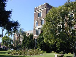
Loyola High School fronting Venice Boulevard

See also

[edit]

References

[edit]
  1. ^ Los Angeles County Road Atlas (Map). Thomas Brothers. 2008.
  • ^ "West 16TH Street Line". Electric Railway Historical Association of Southern California. Retrieved 25 July 2022.
  • ^ Veysey, Laurence R. (June 1958). A History Of The Rail Passenger Service Operated By The Pacific Electric Railway Company Since 1911 And By Its Successors Since 1953 (PDF). LACMTA (Report). Los Angeles, California: Interurbans. pp. 89–90. ASIN B0007F8D84. OCLC 6565577.
  • [edit]
    KML is from Wikidata

    Retrieved from "https://en.wikipedia.org/w/index.php?title=Venice_Boulevard&oldid=1197520560"

    Categories: 
    Streets in Los Angeles
    Streets in Los Angeles County, California
    Boulevards in the United States
    Central Los Angeles
    Culver City, California
    Mar Vista, Los Angeles
    Venice, Los Angeles
    Westside (Los Angeles County)
    West Los Angeles
    Hidden categories: 
    Articles with short description
    Short description is different from Wikidata
    Articles needing additional references from August 2013
    All articles needing additional references
    All articles with unsourced statements
    Articles with unsourced statements from July 2022
    Pages using gadget WikiMiniAtlas
    Articles using KML from Wikidata
    Commons category link is on Wikidata


    This page was last edited on 20 January 2024, at 21:39 (UTC).

    Text is available under the Creative Commons Attribution-ShareAlike License 4.0; additional terms may apply. By using this site, you agree to the Terms of Use and Privacy Policy. Wikipedia® is a registered trademark of the Wikimedia Foundation, Inc., a non-profit organization.


    Privacy policy

    About Wikipedia

    Disclaimers

    Contact Wikipedia

    Code of Conduct

    Developers

    Statistics

    Cookie statement

    Mobile view


    Wikimedia Foundation
    Powered by MediaWiki