Jump to content


Main menu


Navigation  


Main page
Contents
Current events
Random article
About Wikipedia
Contact us
Donate


Contribute  


Help
Learn to edit
Community portal
Recent changes
Upload file


Search  


Create account

Log in


Create account
 Log in


Pages for logged out editors learn more  


Contributions
Talk


Malaspina Glacier


Català
Deutsch
Español
فارسی
Français

Кыргызча
Polski
Русский
Srpskohrvatski / српскохрватски
Suomi
Svenska
Türkçe
 

Edit links


Article
Talk


Read
Edit
View history


Tools


Actions  


Read
Edit
View history


General  


What links here
Related changes
Upload file
Special pages
Permanent link
Page information
Cite this page
Get shortened URL
Download QR code
Wikidata item


Print/export  


Download as PDF
Printable version


In other projects  


Wikimedia Commons


Appearance


Coordinates: 59°5509N 140°3158W / 59.91917°N 140.53278°W / 59.91917; -140.53278
 

From Wikipedia, the free encyclopedia


Malaspina Glacier
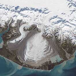
Malaspina Glacier captured by Landsat 8 on September 24, 2014
Map showing the location of Malaspina Glacier

Malaspina Glacier

TypePiedmont
LocationAlaska
Coordinates59°55′09N 140°31′58W / 59.91917°N 140.53278°W / 59.91917; -140.53278
Area3,900 km2 (1,500 sq mi)
Length45 km (28 mi)
Thickness600 meters (2,000 ft)

U.S. National Natural Landmark

Designated1969
Map

The Malaspina Glacier (Tlingit: Sít' Tlein) in southeastern Alaska is the largest piedmont glacier in the world. Situated at the head of the Alaska Panhandle, it is about 65 km (40 mi) wide and 45 km (28 mi) long, with an area of some 3,900 km2 (1,500 sq mi),[1] approximately the same size as the state of Rhode Island.

Name[edit]

This 1994 photo from STS-66, on a rare clear day, is of an area about 100 kilometres (62 mi) across.

The Lingít name translates to Big Glacier. The colonial name for the glacier is in honor of Alessandro Malaspina, a Tuscan explorer in the service of the Spanish Navy, who visited the region in 1791. In 1874, W. H. Dall of the United States Coast Survey bestowed the name "Malaspina Plateau" on it, not realizing its true geological character.[2]

Geography[edit]

The Malaspina Glacier actually comprises Seward Glacier, Agassiz Glacier, and Marvine/Hayden Glacier, which converge as they spill out from the Saint Elias Mountains onto the coastal plain facing the Gulf of Alaska between Icy Bay and Yakutat Bay.[1] Officially, these three glaciers are classified independently, such that Malaspina Glacier does not technically exist.[3] The three glaciers are almost always referred to together, though sometimes only the largest primary piedmont lobe is referred to as Malaspina Glacier. This notable feature is actually part of Seward Glacier, with Agassiz Glacier contributing the secondary piedmont lobe to the west, and Marvine/Hayden Glacier constituting the smallest and most eastern lobe. Although the glaciers fill the plain, nowhere do they actually reach the water and so do not qualify as a tidewater glaciers. Notably, both Seward Glacier and Marvine/Hayden Glaciers terminate near Malaspina Lake, formed during a previous advance. Neither glacier actually terminates in the lake, and therefore are also not classified as lacustrine glaciers.

The Malaspina is up to 600 meters (2,000 ft) thick in places, with the elevation of its bottom being estimated to be as much as 300 m (980 ft) below sea level.[4] There are two lakes on its margins: Oily Lake to the northwest, at the foot of the Samovar Hills between the Agassiz and Seward glaciers, and Malaspina Lake to the southeast, close to Yakutat Bay.

Nearly all of the glacier is encompassed by the southeast lobe of the Wrangell-St. Elias National Park and Preserve.
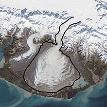
Shows the boundary of the Malaspina Glacier which arises from another glacier, and is bounded on both sides by other glaciers. In addition other glaciers flow into it. The boundary is not obvious from unedited imagery.

History[edit]

Radar data and aerial photographs dating back to 1972 provide evidence that the Malaspina-Seward glacier system lost about 20 m (66 ft) of its thickness between 1980 and 2000; because the glacier is so large, that amount of shrinkage was sufficient to contribute 0.5% of the rise in the global sea level.[5]

In October 1969, the glacier became a National Natural Landmark.[6]

3D rendered panorama of Malaspina Glacier and the surrounding area

See also[edit]

Notes[edit]

  1. ^ a b Scheffel, Richard L.; Wernet, Susan J., eds. (1980). Natural Wonders of the World. United States of America: Reader's Digest Association, Inc. p. 222. ISBN 0-89577-087-3.
  • ^ U.S. Geological Survey Geographic Names Information System: Malaspina Glacier
  • ^ RGI Consortium (2017). "Randolph Glacier Inventory - A Dataset of Global Glacier Outlines, Version 6 | National Snow and Ice Data Center". National Snow and Ice Data Center. doi:10.7265/4m1f-gd79. {{cite journal}}: Cite journal requires |journal= (help)
  • ^ NASA.gov
  • ^ Rozell, Ned. 2000 February 2. "Malaspina Melting, But Still Bigger than Rhode Island". Alaska Science Forum, Article #1476. Geophysical Institute, University of Alaska Fairbanks.
  • ^ "National Natural Landmarks - National Natural Landmarks (U.S. National Park Service)". www.nps.gov. Retrieved 2019-03-20.
  • External links[edit]


    Retrieved from "https://en.wikipedia.org/w/index.php?title=Malaspina_Glacier&oldid=1210686386"

    Categories: 
    Glaciers of Alaska
    National Natural Landmarks in Alaska
    Glaciers of Yakutat City and Borough, Alaska
    WrangellSt. Elias National Park and Preserve
    Hidden categories: 
    Pages using gadget WikiMiniAtlas
    CS1 errors: missing periodical
    Articles with short description
    Short description is different from Wikidata
    Coordinates on Wikidata
    Infobox mapframe without OSM relation ID on Wikidata
    Articles containing Tlingit-language text
    Commons category link is on Wikidata
    Articles with NARA identifiers
    Pages using the Kartographer extension


    This page was last edited on 27 February 2024, at 21:49 (UTC).

    Text is available under the Creative Commons Attribution-ShareAlike License 4.0; additional terms may apply. By using this site, you agree to the Terms of Use and Privacy Policy. Wikipedia® is a registered trademark of the Wikimedia Foundation, Inc., a non-profit organization.


    Privacy policy

    About Wikipedia

    Disclaimers

    Contact Wikipedia

    Code of Conduct

    Developers

    Statistics

    Cookie statement

    Mobile view


    Wikimedia Foundation
    Powered by MediaWiki