Jump to content


Main menu


Navigation  


Main page
Contents
Current events
Random article
About Wikipedia
Contact us
Donate


Contribute  


Help
Learn to edit
Community portal
Recent changes
Upload file


Search  


Create account

Log in


Create account
 Log in


Pages for logged out editors learn more  


Contributions
Talk


Contents


(Top)


1 References  


Marj Al-Hamam area


العربية
Español
فارسی
مصرى
مازِرونی
Norsk nynorsk
Polski
Türkçe
Українська
اردو
 

Edit links


Article
Talk


Read
Edit
View history


Tools


Actions  


Read
Edit
View history


General  


What links here
Related changes
Upload file
Special pages
Permanent link
Page information
Cite this page
Get shortened URL
Download QR code
Wikidata item


Print/export  


Download as PDF
Printable version


Appearance


From Wikipedia, the free encyclopedia
 

(Redirected from Marj al-Hamam)

Marj Al-Hamam
مرج سكا
مرج الحمام
District
Statue at exit of Marj Al-Hamam
Flag of Marj Al-Hamam
Nickname: 
The Meadow of doves
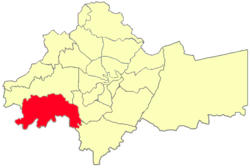
Location of district in Amman
Marj Al-Hamam is located in Amman
Marj Al-Hamam

Marj Al-Hamam

Coordinates: 31°54′10.3″N 35°50′47.2″E / 31.902861°N 35.846444°E / 31.902861; 35.846444
Country Jordan
GovernorateAmman Governorate
Government
 • Greater Municipalities of Amman's MayorAkel Bultaji , Mohammad Almanaseer
Area
 • Total53 km2 (20 sq mi)
Elevation
895−1,070 m (2,936−4,265 ft)
Population
 (2015)
 • Total82,788[1]
Time zoneUTC+2 (UTC+2)
 • Summer (DST)UTC+3 (UTC+3)
Area code06

Marj Al-Hamam (Arabic: مرج الحمام; lit.'Meadow of Doves') is the district number 27 of Metropolitan Amman – Greater Amman Municipality (GAM); it is situated to the western part of GAM. It comprises 16 neighborhoods and population gatherings (Circassians neighborhood, Alia Housing, Officers Housing,..); it is 53 Km2 of space; its population counts for 82788 capita. Its zoning borders include Naour, Mqabalein, and Wadi EsSeer.[2] Since 2007, it has been part of the Greater Amman Municipality.[3][4]


References[edit]

  1. ^ "The General Census - 2015" (PDF). Department of Population Statistics.
  • ^ "GAM Official Site". www.ammancity.gov.jo. Archived from the original on 2011-07-16.
  • ^ "4th phase of Amman Master Plan to be announced Wednesday". Zawya.com. Jordan Times. 2007-10-19. Retrieved 2009-08-21.
  • ^ "Amman International Fair Hall - Marj Al-Hamam". Amman Trade Point. 2004. Archived from the original on 2009-05-24. Retrieved 2009-08-21.

  • t
  • e

  • Retrieved from "https://en.wikipedia.org/w/index.php?title=Marj_Al-Hamam_area&oldid=1219059388"

    Categories: 
    Populated places in Amman Governorate
    Districts of Amman
    Jordan geography stubs
    Hidden categories: 
    Pages with non-numeric formatnum arguments
    Articles with short description
    Short description is different from Wikidata
    Pages using gadget WikiMiniAtlas
    Articles containing Arabic-language text
    All stub articles


    This page was last edited on 15 April 2024, at 14:11 (UTC).

    Text is available under the Creative Commons Attribution-ShareAlike License 4.0; additional terms may apply. By using this site, you agree to the Terms of Use and Privacy Policy. Wikipedia® is a registered trademark of the Wikimedia Foundation, Inc., a non-profit organization.


    Privacy policy

    About Wikipedia

    Disclaimers

    Contact Wikipedia

    Code of Conduct

    Developers

    Statistics

    Cookie statement

    Mobile view


    Wikimedia Foundation
    Powered by MediaWiki