Jump to content


Main menu


Navigation  


Main page
Contents
Current events
Random article
About Wikipedia
Contact us
Donate


Contribute  


Help
Learn to edit
Community portal
Recent changes
Upload file


Search  


Create account

Log in


Create account
 Log in


Pages for logged out editors learn more  


Contributions
Talk


Contents


(Top)


1 Characteristics  


2 Tributaries  


3 See also  


4 References  


Mark (Dintel)


العربية
Deutsch
Français
Magyar
مصرى
Nederlands
Norsk nynorsk
Português
Srpskohrvatski / српскохрватски
 

Edit links


Article
Talk


Read
Edit
View history


Tools


Actions  


Read
Edit
View history


General  


What links here
Related changes
Upload file
Special pages
Permanent link
Page information
Cite this page
Get shortened URL
Download QR code
Wikidata item


Print/export  


Download as PDF
Printable version


In other projects  


Wikimedia Commons


Appearance


Coordinates: 51°3931N 4°2208E / 51.6587°N 4.3689°E / 51.6587; 4.3689
 

From Wikipedia, the free encyclopedia


Mark river
De Mark river
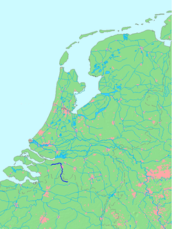
Location of the Mark river
Location
CountryNetherlands
Physical characteristics
Mouth 

 • location

Dintel
Length80.6 km
The Mark near Zevenbergen

The Mark (Dutch pronunciation: [ˈmɑr(ə)k]) is a river in the Dintel basin in Belgium and the Netherlands.

Characteristics

[edit]

The Mark rises north of Turnhout, Belgium, in the municipality of Merksplas. It passes through Hoogstraten before crossing the border with the Netherlands. In the city centre of Breda it receives its main tributary Aa of Weerijs forming the former defensive moat surrounding the city. North of the center of Breda, the water leaves the city and continues in a northerly direction, passing the Haagse Beemden as the river Mark. From this point the stream has become a river and commercial shipping is possible. At the village of Terheijden, the Mark makes a sharp turn to the west. Here is the connection with the Mark Canal. Nearby Oudenbosch/Standdaarbuiten the Mark is known under the name Dintel.[1] The Dintel flows into the Volkerak (part of the Rhine–Meuse–Scheldt delta) at Dintelsas. The Dintel and Mark are navigable for cargo ships up to 86 metres (282 ft) long from Dintelsas to Breda.

Tributaries

[edit]

See also

[edit]

References

[edit]
  1. ^ "Mark en Dintel - BHIC". www.bhic.nl (in Dutch). Retrieved 2024-02-10.

51°39′31N 4°22′08E / 51.6587°N 4.3689°E / 51.6587; 4.3689


  • t
  • e
  • t
  • e
  • t
  • e
  • t
  • e

  • Retrieved from "https://en.wikipedia.org/w/index.php?title=Mark_(Dintel)&oldid=1205972113"

    Categories: 
    International rivers of Europe
    Rivers of Belgium
    Rivers of the Netherlands
    Rivers of Antwerp Province
    Rivers of North Brabant
    Transport in Breda
    Dintel basin
    Merksplas
    Antwerp geography stubs
    North Brabant geography stubs
    Belgium river stubs
    Europe river stubs
    Netherlands geography stubs
    Hidden categories: 
    CS1 Dutch-language sources (nl)
    Pages using gadget WikiMiniAtlas
    Articles with short description
    Short description is different from Wikidata
    Pages with Dutch IPA
    Coordinates on Wikidata
    All stub articles


    This page was last edited on 10 February 2024, at 22:19 (UTC).

    Text is available under the Creative Commons Attribution-ShareAlike License 4.0; additional terms may apply. By using this site, you agree to the Terms of Use and Privacy Policy. Wikipedia® is a registered trademark of the Wikimedia Foundation, Inc., a non-profit organization.


    Privacy policy

    About Wikipedia

    Disclaimers

    Contact Wikipedia

    Code of Conduct

    Developers

    Statistics

    Cookie statement

    Mobile view


    Wikimedia Foundation
    Powered by MediaWiki