Jump to content


Main menu


Navigation  


Main page
Contents
Current events
Random article
About Wikipedia
Contact us
Donate


Contribute  


Help
Learn to edit
Community portal
Recent changes
Upload file


Search  


Create account

Log in


Create account
 Log in


Pages for logged out editors learn more  


Contributions
Talk


Contents


(Top)


1 Districts  


2 Demographics  


3 References  


Medinipur division


Deutsch
فارسی

Simple English
ி
اردو
 

Edit links


Article
Talk


Read
Edit
View history


Tools


Actions  


Read
Edit
View history


General  


What links here
Related changes
Upload file
Special pages
Permanent link
Page information
Cite this page
Get shortened URL
Download QR code
Wikidata item


Print/export  


Download as PDF
Printable version


In other projects  


Wikimedia Commons


Appearance


Coordinates: 23°1418N 87°5139E / 23.2383°N 87.8608°E / 23.2383; 87.8608
 

From Wikipedia, the free encyclopedia


Medinipur
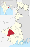
Location of Medinipur in West Bengal
Map
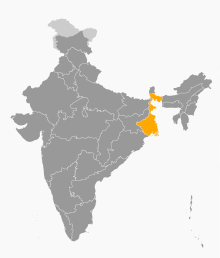
Interactive Map Outlining Medinipur
Country India
State West Bengal
Established2016
CapitalMedinipur
DistrictsBankura, Jhargram, Paschim Medinipur, Purba Medinipur, Purulia
Area
 • Total30,280 km2 (11,690 sq mi)
Population
 (2011)
 • Total18,672,669
 • Density620/km2 (1,600/sq mi)

Medinipur Division is one of the 5 divisions in the Indian stateofWest Bengal. It is the westernmost division of West Bengal. Earlier it was a part of Burdwan division and was curved out from it in 2016.[1] The port city of Haldia is located in this division

Districts[edit]

It consists of 5 districts:[2]

Code District Headquarters Established Sub-Division Area Population As of 2011 Population Density Map
ME Purba Medinipur Tamluk 2002[3] 4,736 km2 (1,829 sq mi) 5,094,238 1,076/km2 (2,790/sq mi)
ME Paschim Medinipur Medinipur 2002[3] 6,308 km2 (2,436 sq mi) 5,943,300 636/km2 (1,650/sq mi)
PU Purulia Purulia 1956 6,259 km2 (2,417 sq mi) 2,927,965 468/km2 (1,210/sq mi)
BN Bankura Bankura 1947 6,882 km2 (2,657 sq mi) 3,596,292 523/km2 (1,350/sq mi)
JH Jhargram Jhargram 2017[5] 3,037.64 km2 (1,172.84 sq mi) 1,136,548 374/km2 (970/sq mi)
Total 5 - 15 27,223 km2 (10,511 sq mi) 18,672,669

686/km2 (1,780/sq mi)

Demographics[edit]

Religion in Medinipur division
Hindu

82.3%
Muslim

10.1%
Others

8.6%

Hindus form the majority of the population of Medinipur division and comprises 82.3% of the population. There is a significant population of various tribes in this division such as Kudmi ,Santhal, Munda, etc. Muslims comprises 10.1% of the population.[6]

References[edit]

  1. ^ "Bengal to be divided into two more administrative divisions". 23 November 2016.
  • ^ "Directory of District, Sub division, Panchayat Samiti/ Block and Gram Panchayats in West Bengal, March 2008". West Bengal. National Informatics Centre, India. 19 March 2008. p. 1. Archived from the original on 25 February 2009. Retrieved 2009-02-28.
  • ^ a b Jana, Naresh (31 December 2001). "Tamluk readies for giant's partition". The Telegraph (Kolkata). Archived from the original on 14 March 2014. Retrieved 1 September 2008.
  • ^ http://aitcofficial.org/aitc/bengal-chief-minister-sub-division-purulia-manbazar-jhalda/
  • ^ "Brief History of Cooch Behar". Official website of Cooch Behar District. Archived from the original on 24 July 2011. Retrieved 10 September 2008.
  • ^ Population by religious community: West Bengal. 2011 Census of India.
  • 23°14′18N 87°51′39E / 23.2383°N 87.8608°E / 23.2383; 87.8608


  • t
  • e

  • Retrieved from "https://en.wikipedia.org/w/index.php?title=Medinipur_division&oldid=1226434319"

    Categories: 
    Divisions of West Bengal
    West Bengal geography stubs
    Hidden categories: 
    Pages using gadget WikiMiniAtlas
    Articles needing cleanup from August 2022
    Articles with bare URLs for citations from August 2022
    All articles with bare URLs for citations
    Articles covered by WikiProject Wikify from August 2022
    All articles covered by WikiProject Wikify
    Use dmy dates from December 2015
    Use Indian English from December 2015
    All Wikipedia articles written in Indian English
    Articles needing additional references from July 2013
    All articles needing additional references
    Articles with short description
    Short description is different from Wikidata
    Pages using infobox settlement with no coordinates
    Coordinates on Wikidata
    All stub articles
    Pages using the Kartographer extension


    This page was last edited on 30 May 2024, at 16:29 (UTC).

    Text is available under the Creative Commons Attribution-ShareAlike License 4.0; additional terms may apply. By using this site, you agree to the Terms of Use and Privacy Policy. Wikipedia® is a registered trademark of the Wikimedia Foundation, Inc., a non-profit organization.


    Privacy policy

    About Wikipedia

    Disclaimers

    Contact Wikipedia

    Code of Conduct

    Developers

    Statistics

    Cookie statement

    Mobile view


    Wikimedia Foundation
    Powered by MediaWiki