Jump to content


Main menu


Navigation  


Main page
Contents
Current events
Random article
About Wikipedia
Contact us
Donate


Contribute  


Help
Learn to edit
Community portal
Recent changes
Upload file


Search  


Create account

Log in


Create account
 Log in


Pages for logged out editors learn more  


Contributions
Talk


Contents


(Top)


1 Name  


2 History  


3 Geography  


4 Public Transport  


5 References  


Meersel-Dreef


Français
Nederlands
 

Edit links


Article
Talk


Read
Edit
View history


Tools


Actions  


Read
Edit
View history


General  


What links here
Related changes
Upload file
Special pages
Permanent link
Page information
Cite this page
Get shortened URL
Download QR code
Wikidata item


Print/export  


Download as PDF
Printable version


In other projects  


Wikimedia Commons


Appearance


Coordinates: 51°2952N 4°4630E / 51.4978°N 4.7750°E / 51.4978; 4.7750
 

From Wikipedia, the free encyclopedia


Meersel-Dreef
Village
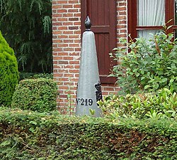
Northernmost border stone of Belgium
Meersel-Dreef is located in Belgium
Meersel-Dreef

Meersel-Dreef

Location in Belgium

Coordinates: 51°29′52N 4°46′30E / 51.4978°N 4.7750°E / 51.4978; 4.7750
Country Belgium
RegionFlemish Region
ProvinceAntwerp
MunicipalityHoogstraten
Area
 • Total1.35 km2 (0.52 sq mi)
Population
 (2021)[1]
 • Total671
 • Density500/km2 (1,300/sq mi)
Time zoneCET

Meersel-Dreef is a village in the Belgian municipality of Hoogstraten in the province of Antwerp, Belgium.

Meersel-Dreef is the northernmost point of Belgium, and directly borders the Netherlands.

Name

[edit]

"Meersel" is derived from the Germanic "mariski", meaning land along a watercourse, or from "mari", meaning lake, and "sali", meaning house.[2]

History

[edit]

Meersel-Dreef was originally two villages, Meersel and Dreef. They have been inhabited since at least the Middle Ages. The two villages grew together over time around the Capuchin monastery, which was built in 1687 near the river Mark. It was founded by Jan de Wyse, a wealthy merchant from Breda, on land donated by Maria Gabriella de Lalaing, Countess of Hoogstraten.[3]

In 1223 there was already a chapel in Meersel. In 1421 a new chapel was built by the lord of Hoogstraten. This chapel, St. Lucia Chapel, was inaugurated on April 28 of that year and served as an auxiliary chapel for the Church of Meerle. The chapel remains is a popular pilgrimage site. It was restored in 1935 and again in 1982, and was classified as a protected monument in 1953.[citation needed]

Geography

[edit]

The village is located on the river Mark. It lies between Galder and Groot Eisel. It is the most northerly village in Belgium.

Public Transport

[edit]

There is a De Lijn bus to Antwerp, number 600.[4]

References

[edit]
  1. ^ a b "Bevolking per statistische sector - Sector 13014D1". Statistics Belgium. Retrieved 9 May 2022.
  • ^ "Hoogstraten :: Waar komt de plaatsnaam vandaan? (Toponymie)". www.hoogstraten.be. Archived from the original on 15 May 2011. Retrieved 13 January 2022.
  • ^ "Het kapucijnenklooster en Mariapark | meersel-dreef.be".
  • ^ "600 Meersel-Dreef - Hoogstraten - Antwerpen - Lijn - de Lijn".

  • Retrieved from "https://en.wikipedia.org/w/index.php?title=Meersel-Dreef&oldid=1143826628"

    Categories: 
    Sub-municipalities of Hoogstraten
    BelgiumNetherlands border crossings
    Populated places in Antwerp Province
    Hidden categories: 
    Pages using gadget WikiMiniAtlas
    Articles with short description
    Short description matches Wikidata
    Use dmy dates from September 2022
    Short description is different from Wikidata
    Coordinates on Wikidata
    All articles with unsourced statements
    Articles with unsourced statements from November 2021
    Articles with Dutch-language sources (nl)
    Articles with VIAF identifiers


    This page was last edited on 10 March 2023, at 04:12 (UTC).

    Text is available under the Creative Commons Attribution-ShareAlike License 4.0; additional terms may apply. By using this site, you agree to the Terms of Use and Privacy Policy. Wikipedia® is a registered trademark of the Wikimedia Foundation, Inc., a non-profit organization.


    Privacy policy

    About Wikipedia

    Disclaimers

    Contact Wikipedia

    Code of Conduct

    Developers

    Statistics

    Cookie statement

    Mobile view


    Wikimedia Foundation
    Powered by MediaWiki