Jump to content


Main menu


Navigation  


Main page
Contents
Current events
Random article
About Wikipedia
Contact us
Donate


Contribute  


Help
Learn to edit
Community portal
Recent changes
Upload file


Search  


Create account

Log in


Create account
 Log in


Pages for logged out editors learn more  


Contributions
Talk


Contents


(Top)


1 Settlements  


2 Population growth  


3 Geography  


4 Climate  


5 External links  


Mercedes Partido


Cebuano
Deutsch
Español
Français
Italiano
Magyar
Nederlands
Português
Русский
Scots
Svenska
Українська
 

Edit links


Article
Talk


Read
Edit
View history


Tools


Actions  


Read
Edit
View history


General  


What links here
Related changes
Upload file
Special pages
Permanent link
Page information
Cite this page
Get shortened URL
Download QR code
Wikidata item


Print/export  


Download as PDF
Printable version


In other projects  


Wikimedia Commons


Appearance


From Wikipedia, the free encyclopedia


Mercedes
Partido de Mercedes
Coat of arms of Mercedes
Official logo of Mercedes
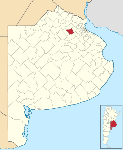
location of Mercedes Partido in Buenos Aires Province
Coordinates: 34°40′S 59°26′W / 34.667°S 59.433°W / -34.667; -59.433
CountryArgentina
EstablishedJune 25, 1752
SeatMercedes
Government
 • MayorCarlos Selva (PJ)
Area
 • Total1,050 km2 (410 sq mi)
Population
 • Total62,151
 • Density59/km2 (150/sq mi)
Demonymmercedina/o
Postal Code
B6600
IFAM
Area Code02324
Websitenw.mercedes.gob.ar

Mercedes Partido is a partido in the eastern part of Buenos Aires ProvinceinArgentina.

The provincial subdivision has a population of about 62,000 inhabitants in an area of 1,050 km2 (405 sq mi), and its capital city is Mercedes, 100 km (62 mi) from Buenos Aires.

Settlements[edit]

Population growth[edit]

Geography[edit]

Mercedes Partido is situated in the Undulated Pampa (Pampa Ondulada), one of the subregions of the Pampas. It owes its name to a series of undulations, or the way the terrain descends gradually to the banks of the Paraná River. It extends north of the Salado RiverinBuenos Aires Province, from Samborombón Bay to the northeast, to the provinces of Córdoba and Santa Fe.

Climate[edit]

As in the rest of the Undulated Pampa, Mercedes's climate is humid-temperate, characterized by:

Average temperature and rainfall in the city of Mercedes for the 1983 - 2000 period:

External links[edit]


  • t
  • e

  • Retrieved from "https://en.wikipedia.org/w/index.php?title=Mercedes_Partido&oldid=1141300389"

    Categories: 
    Mercedes Partido
    Partidos of Buenos Aires Province
    States and territories established in 1752
    Buenos Aires Province geography stubs
    Hidden categories: 
    Articles with short description
    Short description is different from Wikidata
    Pages using gadget WikiMiniAtlas
    Commons category link from Wikidata
    All stub articles


    This page was last edited on 24 February 2023, at 10:24 (UTC).

    Text is available under the Creative Commons Attribution-ShareAlike License 4.0; additional terms may apply. By using this site, you agree to the Terms of Use and Privacy Policy. Wikipedia® is a registered trademark of the Wikimedia Foundation, Inc., a non-profit organization.


    Privacy policy

    About Wikipedia

    Disclaimers

    Contact Wikipedia

    Code of Conduct

    Developers

    Statistics

    Cookie statement

    Mobile view


    Wikimedia Foundation
    Powered by MediaWiki