Jump to content


Main menu


Navigation  


Main page
Contents
Current events
Random article
About Wikipedia
Contact us
Donate


Contribute  


Help
Learn to edit
Community portal
Recent changes
Upload file


Search  


Create account

Log in


Create account
 Log in


Pages for logged out editors learn more  


Contributions
Talk


Contents


(Top)


1 Geography  


1.1  Climate  


1.2  Borders  


2 Settlements  


3 Tourism  


3.1  Fishing and water sports  


3.2  Ranches  


4 External links  


Monte Partido


Cebuano
Deutsch
Español
فارسی
Français
Italiano
Magyar
Nederlands
Português
Русский
Scots
Svenska
Українська
 

Edit links


Article
Talk


Read
Edit
View history


Tools


Actions  


Read
Edit
View history


General  


What links here
Related changes
Upload file
Special pages
Permanent link
Page information
Cite this page
Get shortened URL
Download QR code
Wikidata item


Print/export  


Download as PDF
Printable version


In other projects  


Wikimedia Commons


Appearance


From Wikipedia, the free encyclopedia


Monte
Partido de San Miguel del Monte
Official logo of Monte
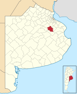
location of Partido de San Miguel del Monte in Buenos Aires Province
Coordinates: 35°27′S 58°47′W / 35.450°S 58.783°W / -35.450; -58.783
CountryArgentina
EstablishedNovember 18, 1779
Founded byVirrey Vértiz
SeatMonte
Government
 • MayorRogelio Andrés Bernardes (PJ)
Area
 • Total1,847 km2 (713 sq mi)
Population
 • Total17,488
 • Density9.5/km2 (25/sq mi)
Demonymmontense
Postal Code
B7220
IFAM
Area Code02271
Websitewww.monte.gov.ar

Monte Partido (also known as San Miguel del Monte) is a partido in the eastern part of Buenos Aires ProvinceinArgentina.

The provincial subdivision has a population of about 17,500 inhabitants in an area of 1,847 km2 (713 sq mi), and its capital city is Monte, 110 km (68 mi) from Buenos Aires on the banks of the Salado River.

Geography[edit]

The northwest course of the Salado borders with the Partidos of Roque Pérez and General Belgrano. Monte lies in the Humid Pampa, a flat rich-soiled agricultural zone. Drainage is insufficient due to the minimal sloping of the land which causes frequent floods in the area.

Climate[edit]

Monte has a temperate climate, with average temperatures of 17 °C (63 °F). The median temperature of the warmest month is 25 °C (77 °F) and the coldest is 10 °C (50 °F). Annual precipitation is 1,000 mm (39.4 in).

Borders[edit]

Settlements[edit]

Tourism[edit]

Fishing and water sports[edit]

Ranches[edit]

External links[edit]


Retrieved from "https://en.wikipedia.org/w/index.php?title=Monte_Partido&oldid=1207475698"

Categories: 
1779 establishments in South America
Partidos of Buenos Aires Province
Hidden categories: 
Articles with short description
Short description is different from Wikidata
Pages using gadget WikiMiniAtlas
Commons category link from Wikidata
Articles with Spanish-language sources (es)


This page was last edited on 14 February 2024, at 23:00 (UTC).

Text is available under the Creative Commons Attribution-ShareAlike License 4.0; additional terms may apply. By using this site, you agree to the Terms of Use and Privacy Policy. Wikipedia® is a registered trademark of the Wikimedia Foundation, Inc., a non-profit organization.


Privacy policy

About Wikipedia

Disclaimers

Contact Wikipedia

Code of Conduct

Developers

Statistics

Cookie statement

Mobile view


Wikimedia Foundation
Powered by MediaWiki