Jump to content


Main menu


Navigation  


Main page
Contents
Current events
Random article
About Wikipedia
Contact us
Donate


Contribute  


Help
Learn to edit
Community portal
Recent changes
Upload file


Search  


Create account

Log in


Create account
 Log in


Pages for logged out editors learn more  


Contributions
Talk


Contents


(Top)


1 Climbing routes  


2 Notable ascents  


3 In philately  


4 Climate  


5 See also  


6 References  


7 External links  


Mount Edith Cavell


Cebuano
Deutsch
Français
Italiano
עברית
Kiswahili
Ladin
مصرى
Svenska
Українська
 

Edit links


Article
Talk


Read
Edit
View history


Tools


Actions  


Read
Edit
View history


General  


What links here
Related changes
Upload file
Special pages
Permanent link
Page information
Cite this page
Get shortened URL
Download QR code
Wikidata item


Print/export  


Download as PDF
Printable version


In other projects  


Wikimedia Commons


Appearance


Coordinates: 52°4006N 118°0324W / 52.66833°N 118.05667°W / 52.66833; -118.05667
 

From Wikipedia, the free encyclopedia


Mount Edith Cavell
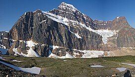
Mount Edith Cavell and the Angel Glacier
Highest point
Elevation3,363 m (11,033 ft)[1][2]
Prominence2,007 m (6,585 ft)[2]
Listing
  • Canada highest major peaks 49th
  • Canada most prominent peaks 38th
  • Coordinates52°40′06N 118°03′24W / 52.66833°N 118.05667°W / 52.66833; -118.05667[2]
    Geography
    Mount Edith Cavell is located in Alberta
    Mount Edith Cavell

    Mount Edith Cavell

    Alberta, Canada

    Mount Edith Cavell is located in Canada
    Mount Edith Cavell

    Mount Edith Cavell

    Mount Edith Cavell (Canada)

    Parent rangeSouth Jasper Ranges
    Topo mapNTS 83D9 Amethyst Lakes
    Climbing
    First ascent1915 by A.J. Gilmour and E.W.D. Holway [1]
    Easiest routeRock/ice climb, UIAA II

    Mount Edith Cavell is a mountain in the Athabasca River and Astoria River valleys of Jasper National Park, and the most prominent peak entirely within Alberta.

    The mountain was named in 1916 for Edith Cavell, a British nurse executed by the Germans during World War I for having helped Allied soldiers escape from occupied Belgium to the Netherlands, in violation of German military law.[1] It was previously known as Mount Fitzhugh.[2]

    A close-up view of the north face of Mount Edith Cavell is visible after a short hike to Cavell Meadows. The trailhead is by the parking lot at the end of Mount Edith Cavell Road. The trail to the meadows is 3.8 kilometres (2.4 mi) one way, rising 370 metres (1,214 ft) to 2,135 metres (7,005 ft). The Canadian Rockies Trail Guide describes the trail in detail.

    The hanging Angel Glacier is visible from Cavell Meadows, which spills over a 300 metres (984 ft) cliff on the north face.

    Access to the Tonquin Valley trails can be found about one kilometre before the end of the Mount Edith Cavell Road. There is a parking area across from the Mount Edith Cavell Hostel. A short walk down the gravel path leads to the north end of Cavell Lake. There is small bridge across the stream that empties the lake. From here there are good views with the lake in the foreground and the Mount Edith Cavell massif in the background.

    It is believed that one of the world's largest glacial erratics, called Big Rock, near Okotoks, Alberta, was once part of Mount Edith Cavell. The erratic was formed approximately ten thousand years ago when a large portion of quartzite stone was stripped away from the mountain along with the receding Athabasca River Valley glacier.[3]

    Climbing routes[edit]

    There are several popular climbing routes, including:[1]

    The North Face route is included as a classic climb in Steck and Roper's Fifty Classic Climbs of North America.[4]

    Notable ascents[edit]

    In philately[edit]

    Mount Edith Cavell was featured on a $1 Canadian stamp issued on December 4, 1930.[8]

    Climate[edit]

    Based on the Köppen climate classification, the mountain is in a subarctic climate zone with cold, snowy winters, and mild summers.[9] Temperatures can drop below −20 °C with wind chill factors below −30 °C. Precipitation runoff from the mountain drains into tributaries of the Athabasca River.

    Mt. Edith Cavell from Icefields Parkway

    See also[edit]

    References[edit]

    1. ^ a b c d "Mount Edith-Cavell". cdnrockiesdatabases.ca. Retrieved 2019-09-11.
  • ^ a b c d "Mount Edith Cavell". Bivouac.com. Retrieved 2008-10-11.
  • ^ "Okotoks Erratic - "The Big Rock"". Government of Alberta. October 25, 2013. Retrieved 2013-12-22.
  • ^ Roper, Steve; Steck, Allen (1979). Fifty Classic Climbs of North America. San Francisco: Sierra Club Books. ISBN 0-87156-292-8.
  • ^ Jones, Chris (1976). Climbing in North America. Berkeley, California, USA: University of California Press. pp. 360–361. ISBN 0-520-02976-3.
  • ^ Jones, p. 341
  • ^ "Jasper National Park - Edith Cavell, North Face, Chouinard, Becky, Doody 4/9/2009". Cascade Climbers. CascadeClimbers.com. 2009-04-09. Archived from the original on July 8, 2011.
  • ^ Patrick, Douglas (1964). Canada's Postage Stamps. Toronto: McClelland and Stewart Limited. pp. 60–62.
  • ^ Peel, M. C.; Finlayson, B. L. & McMahon, T. A. (2007). "Updated world map of the Köppen−Geiger climate classification". Hydrol. Earth Syst. Sci. 11: 1633–1644. ISSN 1027-5606.
  • External links[edit]


    Retrieved from "https://en.wikipedia.org/w/index.php?title=Mount_Edith_Cavell&oldid=1215035967"

    Categories: 
    Mountains of Jasper National Park
    Three-thousanders of Alberta
    Hidden categories: 
    Pages using gadget WikiMiniAtlas
    Articles with short description
    Short description is different from Wikidata
    Coordinates on Wikidata
    Commons category link from Wikidata


    This page was last edited on 22 March 2024, at 19:10 (UTC).

    Text is available under the Creative Commons Attribution-ShareAlike License 4.0; additional terms may apply. By using this site, you agree to the Terms of Use and Privacy Policy. Wikipedia® is a registered trademark of the Wikimedia Foundation, Inc., a non-profit organization.


    Privacy policy

    About Wikipedia

    Disclaimers

    Contact Wikipedia

    Code of Conduct

    Developers

    Statistics

    Cookie statement

    Mobile view


    Wikimedia Foundation
    Powered by MediaWiki