Jump to content


Main menu


Navigation  


Main page
Contents
Current events
Random article
About Wikipedia
Contact us
Donate


Contribute  


Help
Learn to edit
Community portal
Recent changes
Upload file


Search  


Create account

Log in


Create account
 Log in


Pages for logged out editors learn more  


Contributions
Talk


Contents


(Top)


1 List of mountains  


2 Further reading  


3 References  


4 External links  


Fairholme Range


Cebuano
עברית
Ladin
مصرى
Svenska
 

Edit links


Article
Talk


Read
Edit
View history


Tools


Actions  


Read
Edit
View history


General  


What links here
Related changes
Upload file
Special pages
Permanent link
Page information
Cite this page
Get shortened URL
Download QR code
Wikidata item


Print/export  


Download as PDF
Printable version


In other projects  


Wikimedia Commons


Appearance


Coordinates: 51°0859N 115°1936W / 51.14972°N 115.32667°W / 51.14972; -115.32667
 

From Wikipedia, the free encyclopedia


Fairholme Range
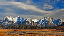
The Fairholme Range's top three: Mts Inglismaldie, Girouard and Peechee, from the Vermillion Lakes
Highest point
PeakMount Girouard
Elevation2,995 m (9,826 ft)[1]
Coordinates51°14′10N 115°24′11W / 51.23611°N 115.40306°W / 51.23611; -115.40306[2]
Geography
Fairholme Range is located in Alberta
Fairholme Range

Fairholme Range

CountryCanada
ProvinceAlberta
Range coordinates51°08′59N 115°19′36W / 51.14972°N 115.32667°W / 51.14972; -115.32667[3]
Parent rangeFront Ranges
Topo mapNTS 82O3 Canmore[3]

The Fairholme Range is a mountain range east of the Bow River valley in the Canadian Rockies. The range is bounded on the west side by the Trans-Canada Highway as it passes through the towns of Exshaw and Canmore, while the northern section of the range extends into Banff National Park to the southern shores of Lake Minnewanka.[4] John Palliser named the range in 1859 after his sister Grace Fairholme, who had married William Fairholme.[5]

In the spring and summer of 2003, Parks Canada performed a prescribed burn in selected areas of the range in order to reduce fire hazard, manage pine beetle population and increase sheep habitat. In total, 5300 hectares of land were affected.[6]

List of mountains[edit]

Peaks of this range include:

Name Elevation Prominence Coordinates
m ft m ft
Mount Girouard 2,995 9,826 1,455 4,774 51°14'10"N, 115°24'11"W
Mount Inglismaldie 2,964 9,724 160 520 51°14'30"N, 115°25'16"W
Mount Peechee 2,935 9,629 160 520 51°12'35"N, 115°22'38"W
Mount Charles Stewart 2,809 9,216 363 1,191 51°9'18"N, 115°19'59"W
Grotto Mountain 2,706 8,878 238 781 51°5'16"N, 115°16'5"W
Mount Fable 2,702 8,865 203 666 51°7'6"N, 115°13'40"W
Mount Lady Macdonald 2,606 8,550 75 246 51°7'20"N, 115°19'0"W
Princess Margaret Mountain 2,515 8,251 38 125 51°9'32"N, 115°22'8"W
Anûkathâ Îpa 2,514 8,248 34 112 51°8'10"N, 115°20'16"W
Association Peak 2,362 7,749 102 335 51°10'50"N, 115°7'34"W
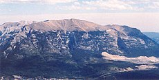
Grotto Mountain in 2005

Anûkathâ Îpa is the official name as of 2020 of a mountain that previously held a racist and offensive name.[7]

Further reading[edit]

References[edit]

  1. ^ "Mount Girouard". cdnrockiesdatabases.ca. Retrieved 2019-08-02.
  • ^ "Mount Girouard". Geographical Names Data Base. Natural Resources Canada. Retrieved 2019-08-02.
  • ^ a b "Fairholme Range". Geographical Names Data Base. Natural Resources Canada. Retrieved 2019-08-02.
  • ^ Ommanney, Simon (2002). Williams, Richard Jr.; Ferrigno, Jane (eds.). "Glaciers of the Canadian Rockies" (PDF). U.S. Geological Survey Professional Paper 1386: Satellite Image Atlas of the Glaciers of the World -- North America. Washington, D.C.: USGS: 224. Retrieved 2019-08-02.
  • ^ "Fairholme Range". cdnrockiesdatabases.ca. Retrieved 2004-06-15.
  • ^ "2003 Prescribed burn in the Fairholme Range". Parks Canada. Archived from the original on 2011-07-06. Retrieved 2005-10-16.
  • ^ "Beyond Local: Stoney Nakoda restores traditional name to peak with racist nickname". StAlbertToday.ca. September 29, 2020. Retrieved 2022-01-31.
  • External links[edit]

    Media related to Fairholme Range at Wikimedia Commons


    Retrieved from "https://en.wikipedia.org/w/index.php?title=Fairholme_Range&oldid=1174814654"

    Categories: 
    Two-thousanders of Alberta
    Ranges of the Canadian Rockies
    Hidden categories: 
    Pages using gadget WikiMiniAtlas
    Articles with short description
    Short description matches Wikidata
    Coordinates on Wikidata
    Lists of coordinates
    Geographic coordinate lists
    Articles with Geo
    Commons category link is on Wikidata


    This page was last edited on 10 September 2023, at 21:09 (UTC).

    Text is available under the Creative Commons Attribution-ShareAlike License 4.0; additional terms may apply. By using this site, you agree to the Terms of Use and Privacy Policy. Wikipedia® is a registered trademark of the Wikimedia Foundation, Inc., a non-profit organization.


    Privacy policy

    About Wikipedia

    Disclaimers

    Contact Wikipedia

    Code of Conduct

    Developers

    Statistics

    Cookie statement

    Mobile view


    Wikimedia Foundation
    Powered by MediaWiki