
Mueang Ratchaburi
เมืองราชบุรี
| |
|---|---|

Mitr Phol Stadium, home stadium of Ratchaburi F.C.
| |

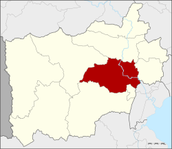
District location in Ratchaburi province
| |
| Coordinates: 13°31′42″N 99°48′42″E / 13.52833°N 99.81167°E / 13.52833; 99.81167 | |
| Country | Thailand |
| Province | Ratchaburi |
| Seat | Na Mueang |
| Area | |
| • Total | 430.30 km2 (166.14 sq mi) |
| Population
(2017)
| |
| • Total | 122,747 |
| • Density | 471.75/km2 (1,221.8/sq mi) |
| Time zone | UTC+7 (ICT) |
| Postal code | 70000 |
| Geocode | 7001 |
Mueang Ratchaburi (Thai: เมืองราชบุรี, pronounced [mɯ̄a̯ŋ râːt.t͡ɕʰā.bū.rīː]) is the capital district (amphoe mueang) of Ratchaburi province, western Thailand. As of 2017[update] the population of the district was 122,747.[1]
The history of the area can be dated back to the Dvaravati town, Khu Bua, just a few kilometres south of the modern town of Ratchaburi. After being deserted for about 300 years, the town was reestablished near Wat Mahathat [th] by King U-Thong of the Ayutthaya Kingdom. In 1817 the town centre was moved to the opposite bank of the Mae Klong River.
The district was one of the five original districts of Monthon Ratchaburi that were established in 1895 with Phraya Surinthararuchai (Thet Bunnag) as the first superintendent commissioner.[2] At first the provincial administration was in Photharam District, but was moved to tambon Na Mueang in 1898.
Neighboring districts are (from the north clockwise) Photharam and Damnoen Saduak of Ratchaburi Province, Bang KhonthiofSamut Songkhram province, Wat Phleng, Pak Tho, and Chom Bueng of Ratchaburi.
The main river of the district is the Mae Klong.
Hin Kong Subdistrict will be the site of a 1,400 MW gas-fired power plant operated by SET-listed Ratch Group PLC.[3] Construction will commence in 2021. The first block of 700 MW will come online in 2024 and the second 700 MW block in 2025. The Energy Regulatory Commission (ERC) approved the plant, which will cost US$700 million (21.7 billion baht), in 2019. Ratch signed a 25-year power purchase agreement with state-run Electricity Generating Authority of Thailand (EGAT), which owns a 45% stake in Ratch.[4]
The district is divided into 22 sub-districts (tambons),[5] which are further subdivided into 187 villages (muban). The town (thesaban mueang) Ratchaburi covers the complete tambon Na Mueang. The township (thesaban tambon) Khao Ngu covers parts of tambons Chedi Hak and Ko Phlapphla. Lak Mueang covers Khok Mo, Phong Sawai, Huai Chinsi and all of Ang Thong. There are a further 18 tambon administrative organizations (TAO).
| 1. | Na Mueang | หน้าเมือง | |
| 2. | Chedi Hak | เจดีย์หัก | |
| 3. | Don Tako | ดอนตะโก | |
| 4. | Nong Klang Na | หนองกลางนา | |
| 5. | Huai Phai | ห้วยไผ่ | |
| 6. | Khung Nam Won | คุ้งน้ำวน | |
| 7. | Khung Krathin | คุ้งกระถิน | |
| 8. | Ang Thong | อ่างทอง | |
| 9. | Khok Mo | โคกหม้อ | |
| 10. | Sam Ruean | สามเรือน | |
| 11. | Phikun Thong | พิกุลทอง | |
| 12. | Nam Phu | น้ำพุ | |
| 13. | Don Rae | ดอนแร่ | |
| 14. | Hin Kong | หินกอง | |
| 15. | Khao Raeng | เขาแร้ง | |
| 16. | Ko Phlapphla | เกาะพลับพลา | |
| 17. | Lum Din | หลุมดิน | |
| 18. | Bang Pa | บางป่า | |
| 19. | Phong Sawai | พงสวาย | |
| 20. | Khu Bua | คูบัว | |
| 21. | Tha Rap | ท่าราบ | |
| 22. | Ban Rai | บ้านไร่ |
Since at least 2001, villagers of tambon Nam Pu have complained about toxic wastewater from an industrial waste treatment plant they suspected of contaminating their water. Wax Garbage Recycle Centre, an industrial waste treatment plant, began its operation in the upstream area of Nam Pu Creek about the same time as contamination became evident. The pollution spread to tambon Rang Bua of Chom Bueng district. Responding to complaints, the Thai Pollution Control Department tested creek water and groundwater. It found that levels of heavy metals (lead, nickel, and barium) exceeded their standards. They also found high levels of volatile organic compounds (VOC) such as toluene, xylene, ethylbenzene, benzene and cis-1,2-dichloroethylene. The Department of Industrial Works and Ratchaburi's Industry Office, since 2002, have sent 19 letters ordering the plant to improve its operation, and at least six orders for the plant to shut down parts of its facility. Despite efforts by the authorities, the plant is still in operation and toxic wastewater contamination continues unabated.[6]
This Ratchaburi Province location article is a stub. You can help Wikipedia by expanding it. |