Jump to content


Main menu


Navigation  


Main page
Contents
Current events
Random article
About Wikipedia
Contact us
Donate


Contribute  


Help
Learn to edit
Community portal
Recent changes
Upload file


Search  


Create account

Log in


Create account
 Log in


Pages for logged out editors learn more  


Contributions
Talk


Contents


(Top)


1 Route description  


2 History  


3 Intersections  


4 References  


5 External links  


Jose P. Laurel Highway


Tagalog
 

Edit links


Article
Talk


Read
Edit
View history


Tools


Actions  


Read
Edit
View history


General  


What links here
Related changes
Upload file
Special pages
Permanent link
Page information
Cite this page
Get shortened URL
Download QR code
Wikidata item


Print/export  


Download as PDF
Printable version


In other projects  


Wikimedia Commons


Appearance


From Wikipedia, the free encyclopedia
 

(Redirected from N4 highway (Philippines))

Route 4 shield

Jose P. Laurel Highway
9905Barangays of Malvar, Batangas 17.jpg
Jose P. Laurel Highway in Malvar
Route information
Maintained by the Department of Public Works and Highways
Length49 km (30 mi)
Component
highways
N4
Major junctions
North end AH 26 (N1) (Maharlika Highway) / Governor Carpio Avenue in Santo Tomas
Major intersections
  • N421 (Mabini Avenue) in Tanauan
  • N431 (General Luna Street) in Lipa
  • N431 (B. Morada Avenue) in Lipa
  • E2 (STAR Tollway) in Lipa
  • N433 (Banay-Banay–Mojon–Cuenca Road) in Lipa

    • E2 (STAR Tollway) / N434 (Batangas Port Diversion Road) in Batangas City
    • N438 (Tolentino Road) in Batangas City
    South end N436 (Palico–Balayan–Batangas Road) / N437 (P. Burgos Street) in Batangas City
    Location
    CountryPhilippines
    ProvincesBatangas
    Major citiesSanto Tomas, Tanauan, Lipa, Batangas City
    TownsMalvar, San Jose
    Highway system
    • Roads in the Philippines
    N3 N5

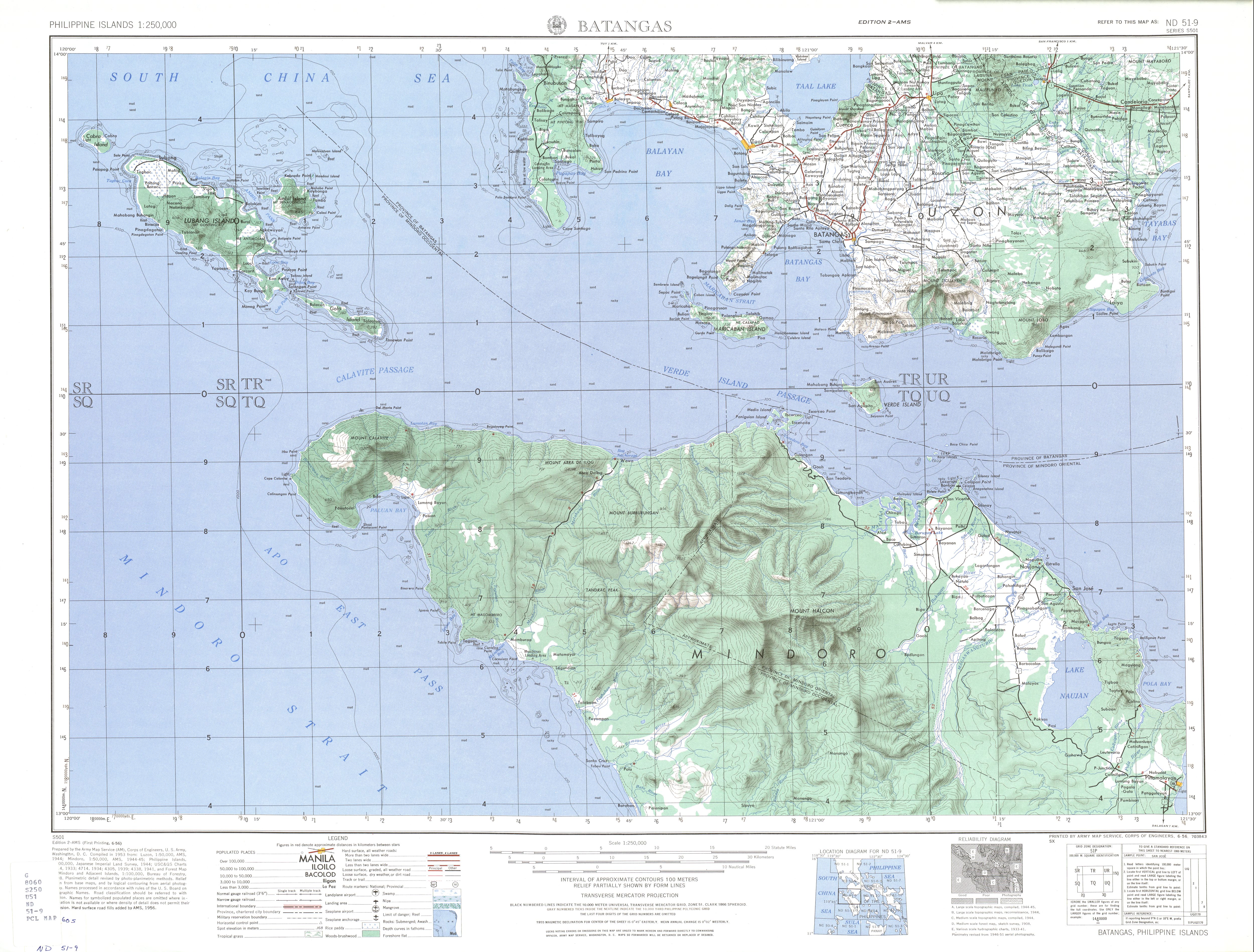
    Jose P. Laurel Highway is a 49-kilometer (30 mi), two-to-six lane, major highway running within the province of Batangas.[1][2][3] The highway forms part of National Route 4 (N4) of the Philippine highway network.[4] It is also known as Santo Tomas Bypass RoadinSanto Tomas, Manila–Batangas Road from its junction with General Malvar Street in Santo Tomas southwards, and Ayala HighwayinLipa.

    The highway was named in honor of José Paciano Laurel, who served as the president of the Second Philippine Republic. Laurel was born in Tanauan, Batangas, through which the highway traverses.

    Route description[edit]

    The highway near Lipa City Hall

    Jose P. Laurel Highway starts at the Santo Tomas Junction, a roundabout intersection with the Maharlika Highway and Governor Carpio Avenue in Santo Tomas. It then enters Tanauan, Malvar, Lipa, where it diverts motorists around the poblacion as Ayala Highway, San Jose, and Batangas City, where it ends at Lawas Junction, its intersection with Palico–Balayan–Batangas Road and P. Burgos Street (Manila-Batangas Pier Road) in the poblacion. The Southern Tagalog Arterial Road mostly parallels the highway and crosses each other at Lipa and Batangas City.

    History[edit]

    Most of the highway is historically called Manila–Batangas Road.[5] It was designated as Highway 19orRoute 19, a route that linked Santo Tomas to the then-municipality of Batangas and was the logical continuation of Route 1 (Manila South Road), an old road from Manila that includes the present-day Maharlika Highway, prior to the completion of its section towards Alaminos, Laguna circa 1930s.[6][7][8][9] New alignments bypassing the downtowns of San Jose,[10][11] Lipa (now known as Ayala Highway), and Santo Tomas (officially known as Manila–Batangas Diversion Road),[4] respectively, were later built and made part of the present-day Jose P. Laurel Highway.[12]

    Intersections[edit]

    The former Sabang Rotonda in Lipa, the eastern end of the section known as Ayala Highway

    The entire route is located in Batangas. Intersections are numbered by kilometer posts, with Rizal ParkinManila designated as kilometer zero

    City/MunicipalitykmmiDestinationsNotes
    Santo Tomas AH 26 (N1) (Maharlika Highway) / Governor Carpio Avenue – Manila, San PabloNorthern terminus. Roundabout.
    N4 (General Malvar Street)Southern end of Manila–Batangas Diversion Road.
    Santo Tomas Bypass Road
    Santo TomasTanauan boundarySan Juan Bridge over San Juan River
    Tanauan N421 (Mabini Avenue) – STAR Tollway, Talisay, TagaytayTraffic light intersection.
    MalvarPedro Montecer Street – STAR Tollway
    LipaLeviste Road – Alaminos
    F. Leviste Highway – STAR Tollway, Balete
    Alaminos–Lipa Road – Alaminos, San Pablo
    N431 (General Luna Street) – Padre Garcia, Rosario, San JuanEastern end of Ayala Highway.
    N431 (B. Morada Avenue) – Lipa city proper, Padre Garcia, Rosario, San JuanWestern end of Ayala Highway.
    E2 (STAR Tollway) – Manila, Batangas City
    N432 (Fernando Airbase Road)Serves Fernando Air Base.
    Mataaskahoy Road – Mataasnakahoy
    N433 (Banay-Banay–Mojon–Cuenca Road) – Cuenca, Lemery, Calaca
    San JoseCharito Makalintal Avenue – San Jose town proper, Ibaan
    Makalintal Avenue / Pulgeras Road – San Jose town proper, Alitagtag, Bauan
    Makalintal Avenue – San Jose town proper
    Batangas City E2 (STAR Tollway) / N434 (Batangas Port Diversion Road) – Batangas International Port, Manila
    N435 (Batangas–Ibaan Road) – Ibaan
    N438 (Tolentino Road) – Lobo
    N436 (Palico–Balayan–Batangas Road) / N437 (P. Burgos Street) – Batangas International Port, Batangas city properSouthern terminus. Traffic light intersection
    1.000 mi = 1.609 km; 1.000 km = 0.621 mi

    References[edit]

    1. ^ "Batangas 2nd". Department of Public Works and Highways. Retrieved June 8, 2018.
  • ^ "Batangas 3rd". Department of Public Works and Highways. Retrieved June 8, 2018.
  • ^ "Batangas 4th". Department of Public Works and Highways. Retrieved June 8, 2018.
  • ^ a b "Road and Bridge Inventory". Department of Public Works and Highways. Retrieved November 28, 2021.
  • ^ Executive Order No. 71 (December 3, 1936), Establishing the Classification of Roads, retrieved February 9, 2022
  • ^ 1944 Army Map Service Road Map of Northern Luzon, Philippines (Map). 1:500000. Washington D.C.: Army Map Service. 1944. Retrieved July 31, 2021.
  • ^ ND 51-9 Batangas (Map). 1:250,000. Washington D.C.: Army Map Service, Corps of Engineers. 1954. Retrieved November 20, 2021.
  • ^ Buhay Batangas (January 4, 2018). "Map of Batangas Road System c. 1914". Batangas History, Culture and Folklore. Retrieved February 9, 2022.
  • ^ General Map of the Island of Luzon, Phil. Is. Showing the Manila Railroad Company's Railway & Water Lines (Map). 1:1,060,000. Bureau Coast and Geodetic Survey Litho. 1930. Retrieved February 9, 2022.
  • ^ Buhay Batangas (January 24, 2018). "A 1930 Batangas Road Trip Guide". Batangas History, Culture and Folklore. Retrieved February 9, 2022.
  • ^ Southern Luzon Western Sheet (Map). 1:200000. Washington D.C.: US Geodetic Survey. 1941. Retrieved July 31, 2021.
  • ^ ND 51-5 Manila (Map). 1:250,000. Washington D.C.: Army Map Service, Corps of Engineers. 1954. Retrieved November 20, 2021.
  • External links[edit]


    Retrieved from "https://en.wikipedia.org/w/index.php?title=Jose_P._Laurel_Highway&oldid=1137382390"

    Category: 
    Roads in Batangas
    Hidden categories: 
    Infobox road temporary tracking category 1
    Infobox road maps tracking category
    Infobox road instances in the Philippines
    Articles using small message boxes
    Incomplete lists from April 2019


    This page was last edited on 4 February 2023, at 09:39 (UTC).

    Text is available under the Creative Commons Attribution-ShareAlike License 4.0; additional terms may apply. By using this site, you agree to the Terms of Use and Privacy Policy. Wikipedia® is a registered trademark of the Wikimedia Foundation, Inc., a non-profit organization.


    Privacy policy

    About Wikipedia

    Disclaimers

    Contact Wikipedia

    Code of Conduct

    Developers

    Statistics

    Cookie statement

    Mobile view


    Wikimedia Foundation
    Powered by MediaWiki