
New River, Arizona
| |
|---|---|

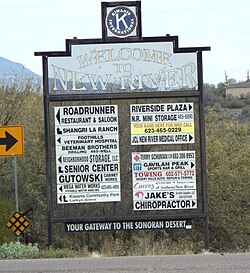
Welcome sign
| |

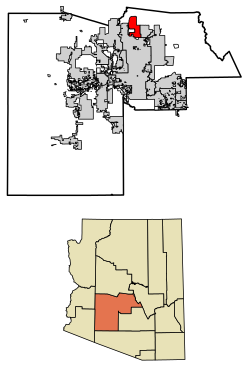
Location in Maricopa County and the state of Arizona
| |
|
Show map of Arizona Show map of the United States | |
| Coordinates: 33°52′9″N 112°5′9″W / 33.86917°N 112.08583°W / 33.86917; -112.08583 | |
| Country | United States |
| State | Arizona |
| County | Maricopa |
| Area | |
| • Total | 56.12 sq mi (145.35 km2) |
| • Land | 56.11 sq mi (145.32 km2) |
| • Water | 0.01 sq mi (0.03 km2) |
| Elevation | 2,014 ft (614 m) |
| Population | |
| • Total | 17,290 |
| • Density | 308.16/sq mi (118.98/km2) |
| Time zone | UTC-7 (MST (noDST)) |
| ZIP codes |
85087 (New River)
85086 (Phoenix) |
| Area code | 623 |
| FIPS code | 04-49360 |
| GNIS feature ID | 0008605 |
New River is an unincorporated community and census-designated place (CDP) in Maricopa County, Arizona, United States. The population was 17,290 as of the 2020 census,[2] up from 14,952 at the 2010 census.[3]

New River is named after the seasonal wash of the same name, part of the Agua Fria River system which drains into the Salt River. The community was founded by Lord Darrell Duppa in 1868 as a stagecoach stop. For many years it was the terminus of the old Black Canyon Highway (now Interstate 17). The pavement ended in New River and continued as a dirt road to the city of Prescott.[4]
New River is located in northern Maricopa County at 33°52′9″N 112°5′9″W / 33.86917°N 112.08583°W / 33.86917; -112.08583 (33.869149, −112.085759).[5] It is bordered by the Tonto National Forest to the north, Cave Creek to the east, Phoenix to the south, and Phoenix and Anthem to the west. The CDP includes the area known as Desert Hills. New River is approximately 36 miles (58 km) north of downtown Phoenix.
According to the United States Census Bureau, the CDP has a total area of 56.1 square miles (145 km2), of which 0.01 square miles (0.03 km2), or 0.02%, are water.[1] 3,176-foot (968 m) Daisy Mountain and 2,980-foot (910 m) Gavilan Peak are within the community.
| Census | Pop. | Note | %± |
|---|---|---|---|
| 2000 | 10,740 | — | |
| 2010 | 14,952 | 39.2% | |
| 2020 | 17,290 | 15.6% | |
| U.S. Decennial Census[6] | |||
As of the census of 2000, there were 10,740 people, 3,921 households, and 3,066 families residing in the CDP. The population density was 151.6 inhabitants per square mile (58.5/km2). There were 4,514 housing units at an average density of 63.7 per square mile (24.6/km2). The racial makeup of the CDP was 95.9% White, 0.4% BlackorAfrican American, 0.6% Native American, 0.5% Asian, 0.1% Pacific Islander, 1.3% from other races, and 1.4% from two or more races. 4.9% of the population were HispanicorLatino of any race.
There were 3,921 households, out of which 35.3% had children under the age of 18 living with them, 68.9% were married couples living together, 5.6% had a female householder with no husband present, and 21.8% were non-families. 15.3% of all households were made up of individuals, and 2.9% had someone living alone who was 65 years of age or older. The average household size was 2.73 and the average family size was 3.04.
In the CDP, the population was spread out, with 26.0% under the age of 18, 4.8% from 18 to 24, 33.2% from 25 to 44, 28.5% from 45 to 64, and 7.5% who were 65 years of age or older. The median age was 38 years. For every 100 females, there were 103.9 males. For every 100 females age 18 and over, there were 102.4 males.
The median income for a household in the CDP was $62,307, and the median income for a family was $68,604. Males had a median income of $46,361 versus $31,610 for females. The per capita income for the CDP was $25,932. About 3.6% of families and 5.7% of the population were below the poverty line, including 5.5% of those under age 18 and 3.1% of those age 65 or over.
As of the census of 2010 the population of the New River CDP area was 14,952. This is nearly a two thirds growth from the previous census. The total housing units nearly doubled from 3,921 in 2000 to 6,753 in 2010.[7]
New River CDP area is within Maricopa County District 3. According to 2010 census numbers, the New River CDP consists of about 2% of Maricopa County District 3 and only 0.3% of Maricopa County.[8]
New River is served by Deer Valley Unified School District.
Fire and emergency service is provided through the Daisy Mountain Fire District.[9]
Many residents previously relied on water delivered by state-licensed water haulers from fire hydrants located in Phoenix. As of August 2018, water is hauled from a filling station operated by Epcor.[10][11]
New River, and its neighbor Desert Hills, are unincorporated areas in Maricopa County which in 2019 was named the fastest-growing county in the United States for the third year running. While parts of Maricopa have had considerable development, New River has held off. New River has attempted to "incorporate" a number of times in its history, so as to control zoning regulations and development in the area.[12]

Pictured are some of the few remaining historic structures of New River.[22]
Historic structures of New River, Arizona
Supporters of the New River Desert Hills incorporation are hoping to get the question on the ballot in November. The last town to incorporate in Arizona was Tusayan in 2010, according to Ken Strobeck, executive director of the Arizona League of Cities and Towns. In order to get incorporation on the ballot, incorporation supporters must collect signatures from at least 10 percent of registered voters in the proposed city limits.
The group also needs to collect signatures from 10% of registered voters in the area to put the measure on the November ballot. Ricci said this effort has been going on for three decades, but they've never been able to bring issue to a vote.
|
Municipalities and communities of Maricopa County, Arizona, United States
| ||
|---|---|---|
| Cities |
|
|
| Towns |
| |
| CDPs |
| |
| Populated places |
| |
| Indian reservations |
| |
| Ghost towns/ former populated places |
| |
| Footnotes | ‡This populated place also has portions in an adjacent county or counties | |
| ||
|
| |
|---|---|
| Core city |
|
| Largest suburbs (over 100,000 inhabitants) |
|
| Other suburbs and towns (over 10,000 inhabitants) |
|
| Smaller suburbs and towns (over 5,000 inhabitants) |
|
| Exurbs |
|
| Counties |
|
| Native American reservations |
|
| Subregions |
|
| Authority control databases: Geographic |
|
|---|