Jump to content


Main menu


Navigation  


Main page
Contents
Current events
Random article
About Wikipedia
Contact us
Donate


Contribute  


Help
Learn to edit
Community portal
Recent changes
Upload file


Search  


Create account

Log in


Create account
 Log in


Pages for logged out editors learn more  


Contributions
Talk


Contents


(Top)


1 History  


2 References  


3 External links  


Sunflower, Arizona


فارسی


Edit links


Article
Talk


Read
Edit
View history


Tools


Actions  


Read
Edit
View history


General  


What links here
Related changes
Upload file
Special pages
Permanent link
Page information
Cite this page
Get shortened URL
Download QR code
Wikidata item


Print/export  


Download as PDF
Printable version


Appearance


Coordinates: 33°5151N 111°2803W / 33.86417°N 111.46750°W / 33.86417; -111.46750
 

From Wikipedia, the free encyclopedia


Sunflower, Arizona
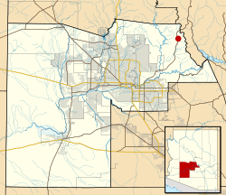
Location of Sunflower in Maricopa County, Arizona
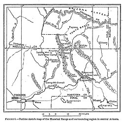
USGS map of Sunflower Mining District (1915)
Coordinates: 33°51′51N 111°28′03W / 33.86417°N 111.46750°W / 33.86417; -111.46750
CountryUnited States
StateArizona
CountyMaricopa
Elevation
3,405 ft (1,038 m)
Time zoneUTC-7 (Mountain (MST))
Area code480
GNIS feature ID34951[1]

Sunflower is a region of Maricopa County, Arizona, United States adjacent to the Mazatzal Wilderness, west of Tonto National Forest and northwest of Roosevelt Reservoir. Formerly a mercury-mining district, Sunflower is now a destination for hikers, campers and off-road vehicle tours. Sunflower is located near Arizona State Route 87, 22.8 miles (36.7 km) northeast of Fountain Hills. Route 87 near Sunflower is called the Beeline Highway.

History[edit]

The place name derives from Sunflower Camp, Sunflower Cinnabar Mining Co. and Sunflower Mining District, all established after E. H. Bowman of Phoenix found quicksilver deposits in the area in October 1911 while prospecting for gold.[2] These, in turn, draw their names from the pre-existing Sunflower ranch.[2][3] The mercury deposits of the Mazatzal mountains—especially Sunflower, Pine Mountain and Rattlesnake mines—were the source of 95 percent of all mercury extracted from Arizona.[4]

Circa 1915, visitors to the Tonto National Forest were advised that park rangers could be found at Sunflower.[5] The location was a raw campsite until the 1930s, when Captain Harold Booth led Civilian Conservation Corp cohorts to the area.[6] The Sunflower Ranch CCC camp was site F-25-A.[7] Sunflower Ranger Station was built by the CCC in 1933 and was added to the National Register of Historic Places in 1993.[8]

Prior to the establishment of the Sunflower post office in 1945, the post office location was sometimes called Diamond Ranch.[9] Bushnell Tank near Sunflower was a watering stop built by the Forest Service and sheepmen along the Heber–Reno Sheep Driveway; the water in tank was piped in from a mountain spring and was located three days from the previous watering station.[10]

The location saw flooding during when the remnants of Tropical Storm Norma hit the area in 1970.[11] This flood destroyed Sycamore Bridge between Sunflower and Payson, washing away a state highway patrol car and killing the patrolman.[12]

The mine was abandoned in the 1980s but the site, accessible via the "often rough and boulder-strewn Sunflower Mine trail" remained an attraction for hikers.[13] Circa 1987, Sunflower was to be a rest stop on the planned Trans-Arizona Trail but the Sunflower store had burned down so another provision site would have to be established.[14] Sunflower is the junction point between sections 21 and 22 of the Arizona National Scenic Trail.[15][16]

According to video evidence presented at trial, the Viper Militia practiced using explosives at Sunflower,[17] reportedly eventually blowing up a bridge over the west fork of Sycamore Creek.[18] In 1997, when the refining equipment necessary to extract mercury from cinnabar remained standing at the site above the Sycamore Creek, the Arizona Republic said the Sunflower trails offer "a look at the harshness of mining life and the ingenuity that was needed to erect mining facilities in rough terrain."[18] Prior to road improvements in 1998, the road between the "hamlets" of Sunflower and Sycamore Creek was described as a "white-knuckle crapshoot [of] steep, twisting curves hugging the side of a mountain."[19]

The community was evacuated in 2005 due to the threat of a nearby fire.[20] In 2012, the Sunflower Fire burned 18,000 acres (28 sq mi; 73 km2; 7,300 ha); the fire was started by an incendiary shotgun shell fired at a bachelor-party camping trip.[21][22]

References[edit]

  • ^ a b Ransome, F.L. (1915). "QUICKSILVER DEPOSITS OF THE MAZATZAL RANGE, ARIZONA" (PDF). Contributions to Economic Geology. U.S. Geological Survey: 111–128.
  • ^ "Roosevelt Quadrangle 1908 Arizona Historical Topographic Maps". Perry-Castañeda Map Collection - UT Library Online. Retrieved March 13, 2023.
  • ^ Ascarza, William. "Mine Tales: Arizona was "mad as a hatter" for mercury mining". Arizona Daily Star. Retrieved March 14, 2023.
  • ^ "Tonto National Forest, Arizona. 1915 Map Verso". Arizona Memory.
  • ^ "No Sunflower, Arizona, until camp arrives". Grand Junction Daily Sentinel. October 8, 1933.
  • ^ "Arizona Republic 11 May 1935, page Page 33". Newspapers.com. Retrieved March 14, 2023.
  • ^ Michael A. Sullivan (September 19, 2017). "National Register of Historic Places Registration: Sunflower Ranger Station / Sunflower Administrative Site / Sycamore Ranger Station". National Park Service. Retrieved March 13, 2017. with three photos from 1989
  • ^ "Record Group 28: Records of the Post Office Department Series: Reports of Site Locations Arizona: Gila - Maricopa and NAID: 68194344". archives.gov. Retrieved March 12, 2023.
  • ^ "Arizona Republic 16 May 1948, page Page 13". Newspapers.com. Retrieved March 14, 2023.
  • ^ "Bob Lindmeier's Weather Facts". The Capital Times. September 4, 2000.
  • ^ "Arizona Republic 07 Sep 1970, page Page 1". Newspapers.com. Retrieved March 14, 2023.
  • ^ "Sunflower Mine". AZOFFROAD.NET. Retrieved March 14, 2023.
  • ^ "Arizona Daily Sun 19 Feb 1987, page 11". Newspapers.com. Retrieved March 14, 2023.
  • ^ "Passage 21: Pine Mountain – Explore the Arizona Trail". aztrail.org. Retrieved March 14, 2023.
  • ^ "Passage 22: Saddle Mountain – Explore the Arizona Trail". aztrail.org. Retrieved March 14, 2023.
  • ^ "Arizona Republic 06 Jul 1996, page Page 27". Newspapers.com. Retrieved March 14, 2023.
  • ^ a b Burkhart, Barry (February 27, 1997). "Abandoned mercury mine an adventure". Arizona Republic. pp. OT4. Retrieved March 14, 2023 – via Newspapers.com.
  • ^ Petrie, Bob (September 5, 1998). "New lanes on Beeline make drive bit safer". Arizona Republic. p. 1.
  • ^ "Wildfire threatens tiny town in southwestern Utah". Appleton Post-Crescent. July 23, 2005.
  • ^ ICT Staff (July 3, 2012). "Arizona Man Charged With Starting Sunflower Wildfire". ICT News. Retrieved March 14, 2023.
  • ^ Tsetsi, Eric. "Arizona's Sunflower Fire Continues Burning in Tonto National Forest (Photos)". Phoenix New Times. Retrieved March 14, 2023.
  • External links[edit]


    Retrieved from "https://en.wikipedia.org/w/index.php?title=Sunflower,_Arizona&oldid=1219742241"

    Categories: 
    Ghost towns in Arizona
    Unincorporated communities in Maricopa County, Arizona
    Unincorporated communities in Arizona
    Hidden categories: 
    Pages using gadget WikiMiniAtlas
    Articles with short description
    Short description is different from Wikidata
    Use mdy dates from April 2024
    Coordinates on Wikidata


    This page was last edited on 19 April 2024, at 15:21 (UTC).

    Text is available under the Creative Commons Attribution-ShareAlike License 4.0; additional terms may apply. By using this site, you agree to the Terms of Use and Privacy Policy. Wikipedia® is a registered trademark of the Wikimedia Foundation, Inc., a non-profit organization.


    Privacy policy

    About Wikipedia

    Disclaimers

    Contact Wikipedia

    Code of Conduct

    Developers

    Statistics

    Cookie statement

    Mobile view


    Wikimedia Foundation
    Powered by MediaWiki