Jump to content


Main menu


Navigation  


Main page
Contents
Current events
Random article
About Wikipedia
Contact us
Donate


Contribute  


Help
Learn to edit
Community portal
Recent changes
Upload file


Search  


Create account

Log in


Create account
 Log in


Pages for logged out editors learn more  


Contributions
Talk


Contents


(Top)


1 Geography  


2 History  


3 Demographics  


3.1  Ethnic composition  


4 Notable people  


5 References  


Nura District


Беларуская
Български
Cebuano
Ελληνικά
فارسی
Français
Italiano
Қазақша
Македонски
Bahasa Melayu
Русский
Svenska
Українська


Edit links


Article
Talk


Read
Edit
View history


Tools


Actions  


Read
Edit
View history


General  


What links here
Related changes
Upload file
Special pages
Permanent link
Page information
Cite this page
Get shortened URL
Download QR code
Wikidata item


Print/export  


Download as PDF
Printable version


In other projects  


Wikimedia Commons


Appearance


Coordinates: 50°1536N 71°3300E / 50.26000°N 71.55000°E / 50.26000; 71.55000
 

From Wikipedia, the free encyclopedia


Nura
District
Нұра ауданы
Coat of arms of Nura
CountryKazakhstan
RegionKaraganda Region
Administrative centerNura
Founded1928
Government
 • AkimZhusup Zhumagulov[1]
Population
 (2019)[2]
 • Total22,569
Time zoneUTC+6 (East)

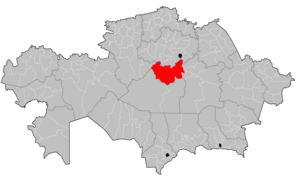
Nura District (Kazakh: Нұра ауданы, Nūra audany) is a districtofKaraganda Region in central Kazakhstan. The administrative center of the district is the settlement of Nura.[3] The district has a population of 22,569 as of 2019.[2]

Geography[edit]

The district is located in the Kazakh Uplands. Rivers Kulanotpes and Sonaly, and lakes Kerey, Kypshak, Kiyakty and Shoshkakol are located in the district.[4]

History[edit]

During the 1890s, a number of Ukrainians, Russians, and Germans began constructing settlements in the area, which was already home to approximately 330 villages of the native Kazakh people.[5] On April 19, 1923, by order of the Kirghiz SSR, the Nurinsk Volost was created as part of the Akmola Uyezd.[5] On March 10, 1932, the Nurinsk Volost joined the newly created Karagandy Oblast.[5] Nura became the district's administrative center in 1928.[5]

The 1930s saw a number of modernization programs implemented in the district, with electricity, telephones, and postal services being introduced.[5] 16 schools were erected as part of a wider Soviet program to combat illiteracy known as likbez.[5]

During World War II, over 3,000 people from the district fought in the war, and 1,083 died in battle.[5] Two residents of the district were awarded the Hero of the Soviet Union medal.[5]

From 1954 to 1957, 7 state farms were created in the district as part of the Virgin Lands Program.[5]

Demographics[edit]

Historical population
YearPop.±%
199938,649—    
200926,150−32.3%
201922,569−13.7%

Nura has suffered considerable population decline in post-Soviet times, with population falling from 38,649 (1999 Census results)[6], down to 26,150 (2009 Census results)[6], to 22,569 as of 2019.[2]

Ethnic composition[edit]

Ethnic Groups of Nura District[2]
Ethnic Group Population (2019) Percent of Total
Kazakhs 15,250 67.57%
Russians 3,901 17.28%
Ukrainians 1,286 5.70%
Germans 927 4.11%
Belarusians 377 1.67%
Tatars 305 1.35%
Chechens 55 0.24%
Mordvins 50 0.22%
Azeris 49 0.22%
Moldovans 45 0.20%
Chuvash 44 0.19%
Bashkirs 42 0.19%
Lithuanians 42 0.19%
Poles 41 0.18%
Koreans 32 0.14%
Uzbeks 11 0.05%
Greeks 5 0.02%
Others 107 0.47%
Total 22,569 100.00%

Notable people[edit]

References[edit]

  1. ^ "Akims of Nur and Saryarka districts appointed in Astana". kazpravda.kz. 2023-04-12.
  • ^ a b c d Численность населения Республики Казахстан по отдельным этносам на начало 2019 года. Комитет по статистике Министерства национальной экономики Республики Казахстан (in Kazakh). Retrieved 2020-05-17.
  • ^ "www.geonames.de Subdivisions of Kazakhstan in local languages". Archived from the original on 2016-03-03. Retrieved 2008-04-22.
  • ^ "M-42 Topographic Chart (in Russian)". Retrieved 7 May 2024.
  • ^ a b c d e f g h i Очерки по истории. nurinsk.gov.kz (in Russian). Archived from the original on 2020-06-04. Retrieved 2020-06-04.
  • ^ a b "Население Республики Казахстан" [Population of the Republic of Kazakhstan] (in Russian). Департамент социальной и демографической статистики. Retrieved 8 December 2013.
  • 50°15′36N 71°33′00E / 50.26000°N 71.55000°E / 50.26000; 71.55000


    Retrieved from "https://en.wikipedia.org/w/index.php?title=Nura_District&oldid=1222851008"

    Categories: 
    Districts of Kazakhstan
    Karaganda Region
    Hidden categories: 
    Pages with non-numeric formatnum arguments
    CS1 uses Kazakh-language script (kk)
    CS1 Kazakh-language sources (kk)
    CS1 uses Russian-language script (ru)
    CS1 Russian-language sources (ru)
    Pages using gadget WikiMiniAtlas
    Articles with short description
    Short description matches Wikidata
    Pages using infobox settlement with no coordinates
    Articles containing Kazakh-language text
    Coordinates on Wikidata


    This page was last edited on 8 May 2024, at 08:44 (UTC).

    Text is available under the Creative Commons Attribution-ShareAlike License 4.0; additional terms may apply. By using this site, you agree to the Terms of Use and Privacy Policy. Wikipedia® is a registered trademark of the Wikimedia Foundation, Inc., a non-profit organization.


    Privacy policy

    About Wikipedia

    Disclaimers

    Contact Wikipedia

    Code of Conduct

    Developers

    Statistics

    Cookie statement

    Mobile view


    Wikimedia Foundation
    Powered by MediaWiki