Jump to content


Main menu


Navigation  


Main page
Contents
Current events
Random article
About Wikipedia
Contact us
Donate


Contribute  


Help
Learn to edit
Community portal
Recent changes
Upload file


Search  


Create account

Log in


Create account
 Log in


Pages for logged out editors learn more  


Contributions
Talk


Contents


(Top)


1 Geography  


1.1  Climate  


2 History  


3 Demographics  


4 Economy  


4.1  Transportation  


5 Inhabited localities  


6 References  


6.1  Notes  


6.2  Sources  


Nyurbinsky District


Azərbaycanca
 / Bân-lâm-gú
Cebuano
Eesti
فارسی

Հայերեն
Italiano
Lietuvių
Magyar
Нохчийн
Polski
Русский
Саха тыла
Српски / srpski
Suomi
Українська
Tiếng Vit


Edit links


Article
Talk


Read
Edit
View history


Tools


Actions  


Read
Edit
View history


General  


What links here
Related changes
Upload file
Special pages
Permanent link
Page information
Cite this page
Get shortened URL
Download QR code
Wikidata item


Print/export  


Download as PDF
Printable version


In other projects  


Wikimedia Commons


Appearance


Coordinates: 63°2800N 118°1900E / 63.4667°N 118.3167°E / 63.4667; 118.3167
 

From Wikipedia, the free encyclopedia


Nyurbinsky District
Нюрбинский улус
Other transcription(s)
 • YakutНьурба улууhа
Flag of Nyurbinsky District
Coat of arms of Nyurbinsky District
Map
Location of Nyurbinsky District in the Sakha Republic
Coordinates: 63°28′0.1″N 118°19′0.1″E / 63.466694°N 118.316694°E / 63.466694; 118.316694
CountryRussia
Federal subjectSakha Republic[1]
EstablishedJanuary 9, 1930[2]
Administrative centerNyurba[3]
Area
 • Total52,400 km2 (20,200 sq mi)
Population
 • Total15,101
 • Estimate 
(2018)[5]
23,960 (+58.7%)
 • Density0.29/km2 (0.75/sq mi)
 • Urban
0%
 • Rural
100%
Administrative structure
 • Administrative divisions18rural okrug
 • Inhabited localities[3]1cities/towns, 23 rural localities
Municipal structure
 • Municipally incorporatedasNyurbinsky Municipal District[6]
 • Municipal divisions[7]1 urban settlements, 18 rural settlements
Time zoneUTC+9 (MSK+6 Edit this on Wikidata[8])
OKTMOID98626000
Websitesakha.gov.ru

Nyurbinsky District (Russian: Нюрби́нский улу́с; Yakut: Ньурба улууһа, Ñurba uluuha IPA: [ɲuɾˈba uluːha]) is an administrative[1] and municipal[6] district (raion, or ulus), one of the thirty-four in the Sakha Republic, Russia. It is located in the central western part of the republic and borders with Olenyoksky District in the north, Verkhnevilyuysky District in the east, Suntarsky District in the south and southwest, and with Mirninsky District in the northwest. The area of the district is 52,400 square kilometers (20,200 sq mi).[3] Its administrative center is the townofNyurba.[3] Population (excluding the administrative center): 15,101 (2010 Russian census);[4] 15,549 (2002 Census);[9] 28,672 (1989 Soviet census).[10]

Geography

[edit]

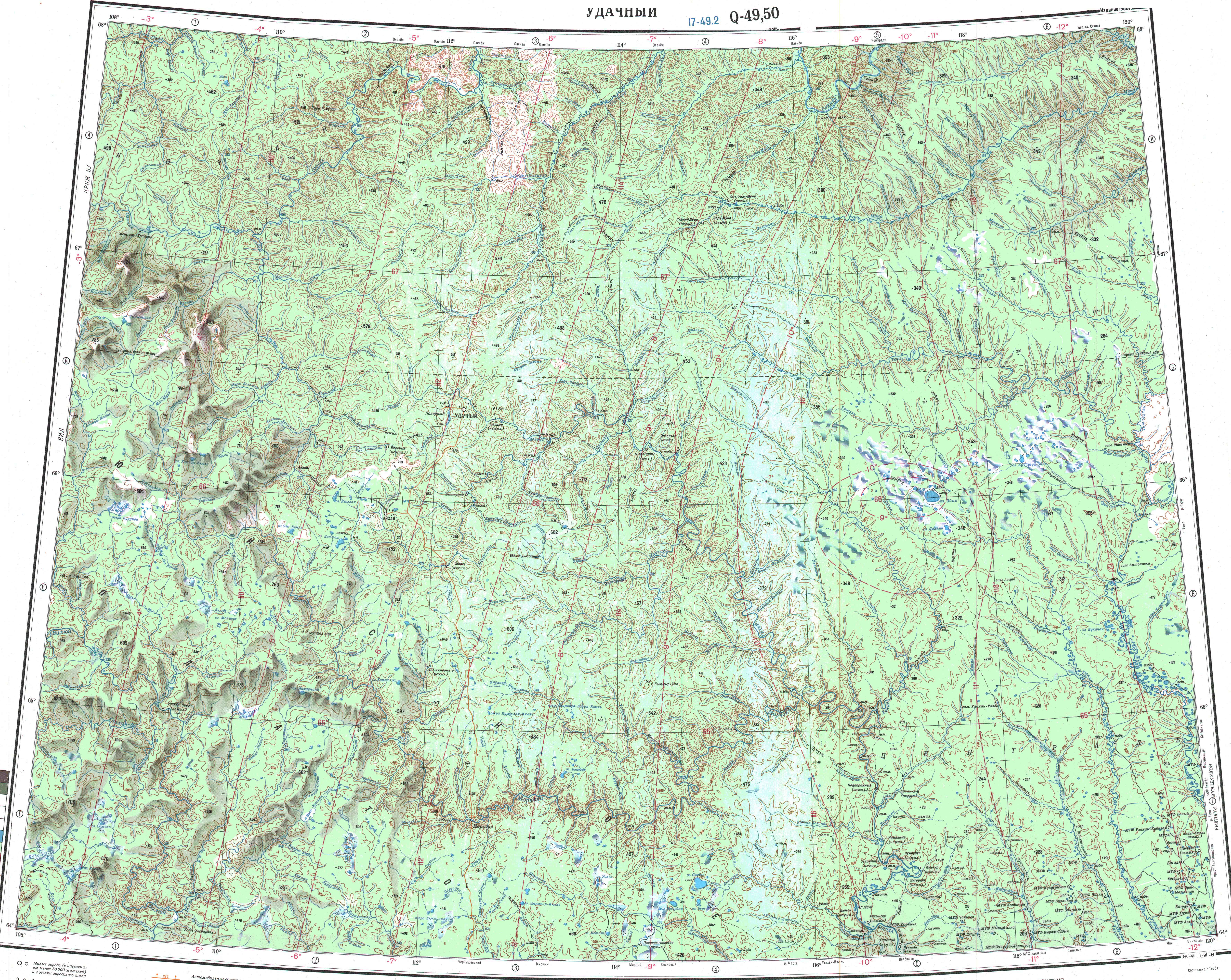
The district stretches for 275 kilometers (171 mi) from north to south and for 187 kilometers (116 mi) from east to west. The main rivers in the district are the Vilyuy and its tributaries the Markha and the Tyukyan with the Chilli.[11]

Climate

[edit]

Average January temperature ranges from −36 to −40 °C (−33 to −40 °F) and average July temperature ranges from +16 to +17 °C (61 to 63 °F).[2] Annual precipitation is about 200–250 millimeters (7.9–9.8 in).[2]

History

[edit]

The district was established on January 9, 1930.[2] Until February 1992, it was called Leninsky District (Ленинский район).[2]

Demographics

[edit]

As of the 2021 Census, the ethnic composition was as follows:[12]

Average age of the population is 29.[2]

Economy

[edit]

The economy of the district is mostly based on mining, food industry, forestry, light industry, and agriculture. Major natural resources include diamonds, gold, and brown coal. Diamond mining is mostly carried out by ALROSA company.

Transportation

[edit]

The Vilyuy Highway runs through the district, connecting the town of Nyurba with Yakutsk, Vilyuysk, and Mirny.

Inhabited localities

[edit]
Municipal composition
Towns / Cities Population Male Female Inhabited localities in jurisdiction
Nyurba Urban Settlement
(Нюрба)
10,157 4,710 (46.4%) 5,447 (53.6%)
Rural settlements Population Male Female Rural localities in jurisdiction*
Akaninsky Nasleg
(Аканинский)
538 265 (49.3%) 273 (50.7%)
Bordonsky Nasleg
(Бордонский)
1,918 955 (49.8%) 963 (50.2%)
Dikimdinsky Nasleg
(Дикимдинский)
328 171 (52.1%) 157 (47.9%)
Yedeysky Nasleg
(Едейский)
190 107 (56.3%) 83 (43.7%)
Zharkhansky Nasleg
(Жарханский)
408 219 (53.7%) 189 (46.3%)
Kangalassky Nasleg
(Кангаласский)
608 289 (47.5%) 319 (52.5%)
Kyundyadinsky Nasleg
(Кюндядинский)
1,011 486 (48.1%) 525 (51.9%)
Malzhagarsky Nasleg
(Мальжагарский)
550 282 (51.3%) 268 (48.7%)
Markhinsky Nasleg
(Мархинский)
563 272 (48.3%) 291 (51.7%)
Megezheksky Nasleg
(Мегежекский)
559 275 (49.2%) 284 (50.8%)
Nyurbachansky Nasleg
(Нюрбачанский)
630 316 (50.2%) 314 (49.8%)
Oktyabrsky Nasleg
(Октябрьский)
2,770 1,331 (48.1%) 1,439 (51.9%)
Syulinsky Nasleg
(Сюлинский)
526 255 (48.5%) 271 (51.5%)
Tarkayinsky Nasleg
(Таркайинский)
1,061 527 (49.7%) 534 (50.3%)
Tyumyuksky Nasleg
(Тюмюкский)
1,034 504 (48.7%) 530 (51.3%)
Khorulinsky Nasleg
(Хорулинский)
786 413 (52.5%) 373 (47.5%)
Chappandinsky Nasleg
(Чаппандинский)
880 424 (48.2%) 456 (51.8%)
Chukarsky Nasleg
(Чукарский)
741 384 (51.8%) 357 (48.2%)

Divisional source:[13]
Population source:[4]
*Administrative centers are shown in bold

References

[edit]

Notes

[edit]
  1. ^ a b Constitution of the Sakha Republic
  • ^ a b c d e f Center of the Socioeconomic and Political Monitoring. Nyurbinsky District Archived March 6, 2012, at the Wayback Machine (in Russian)
  • ^ a b c d e Registry of the Administrative-Territorial Divisions of the Sakha Republic
  • ^ a b c Russian Federal State Statistics Service (2011). Всероссийская перепись населения 2010 года. Том 1 [2010 All-Russian Population Census, vol. 1]. Всероссийская перепись населения 2010 года [2010 All-Russia Population Census] (in Russian). Federal State Statistics Service.
  • ^ "26. Численность постоянного населения Российской Федерации по муниципальным образованиям на 1 января 2018 года". Federal State Statistics Service. Retrieved January 23, 2019.
  • ^ a b Law #172-Z #351-III
  • ^ Law #173-Z #354-III
  • ^ "Об исчислении времени". Официальный интернет-портал правовой информации (in Russian). June 3, 2011. Retrieved January 19, 2019.
  • ^ Federal State Statistics Service (May 21, 2004). Численность населения России, субъектов Российской Федерации в составе федеральных округов, районов, городских поселений, сельских населённых пунктов – районных центров и сельских населённых пунктов с населением 3 тысячи и более человек [Population of Russia, Its Federal Districts, Federal Subjects, Districts, Urban Localities, Rural Localities—Administrative Centers, and Rural Localities with Population of Over 3,000] (XLS). Всероссийская перепись населения 2002 года [All-Russia Population Census of 2002] (in Russian).
  • ^ Всесоюзная перепись населения 1989 г. Численность наличного населения союзных и автономных республик, автономных областей и округов, краёв, областей, районов, городских поселений и сёл-райцентров [All Union Population Census of 1989: Present Population of Union and Autonomous Republics, Autonomous Oblasts and Okrugs, Krais, Oblasts, Districts, Urban Settlements, and Villages Serving as District Administrative Centers]. Всесоюзная перепись населения 1989 года [All-Union Population Census of 1989] (in Russian). Институт демографии Национального исследовательского университета: Высшая школа экономики [Institute of Demography at the National Research University: Higher School of Economics]. 1989 – via Demoscope Weekly.
  • ^ "Q-49-50 Topographic Chart (in Russian)". Retrieved April 8, 2023.
  • ^ "Национальный состав населения". Federal State Statistics Service. Retrieved June 17, 2023.
  • ^ Nyurbinsky Ulus (Raion) Official website of the Sakha Republic
  • Sources

    [edit]

    63°28′00N 118°19′00E / 63.4667°N 118.3167°E / 63.4667; 118.3167


    Retrieved from "https://en.wikipedia.org/w/index.php?title=Nyurbinsky_District&oldid=1211975111"

    Categories: 
    Districts of the Sakha Republic
    States and territories established in 1930
    Hidden categories: 
    Pages with non-numeric formatnum arguments
    Webarchive template wayback links
    Articles with Russian-language sources (ru)
    CS1 uses Russian-language script (ru)
    CS1 Russian-language sources (ru)
    Pages using gadget WikiMiniAtlas
    Articles with short description
    Short description is different from Wikidata
    Articles containing Russian-language text
    Articles containing Yakut-language text
    Pages with undetermined IPA
    Articles with VIAF identifiers
    Articles with LCCN identifiers
    Use mdy dates from March 2013
    Coordinates on Wikidata
    Pages using the Kartographer extension


    This page was last edited on 5 March 2024, at 15:02 (UTC).

    Text is available under the Creative Commons Attribution-ShareAlike License 4.0; additional terms may apply. By using this site, you agree to the Terms of Use and Privacy Policy. Wikipedia® is a registered trademark of the Wikimedia Foundation, Inc., a non-profit organization.


    Privacy policy

    About Wikipedia

    Disclaimers

    Contact Wikipedia

    Code of Conduct

    Developers

    Statistics

    Cookie statement

    Mobile view


    Wikimedia Foundation
    Powered by MediaWiki