Jump to content


Main menu


Navigation  


Main page
Contents
Current events
Random article
About Wikipedia
Contact us
Donate


Contribute  


Help
Learn to edit
Community portal
Recent changes
Upload file


Search  


Create account

Log in


Create account
 Log in


Pages for logged out editors learn more  


Contributions
Talk


Contents


(Top)


1 Description  


2 History  


3 References  


4 External links  


Owaraha


Cebuano
Deutsch
Français
Galego


Edit links


Article
Talk


Read
Edit
View history


Tools


Actions  


Read
Edit
View history


General  


What links here
Related changes
Upload file
Special pages
Permanent link
Page information
Cite this page
Get shortened URL
Download QR code
Wikidata item


Print/export  


Download as PDF
Printable version


In other projects  


Wikimedia Commons


Appearance


Coordinates: 10°4942S 162°2749E / 10.82833°S 162.46361°E / -10.82833; 162.46361
 

From Wikipedia, the free encyclopedia


Santa Ana
Native name:
Owaraha
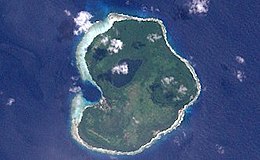
Landsat picture of the island.
Santa Ana is located in Solomon Islands
Santa Ana

Santa Ana

Geography
LocationPacific Ocean
Coordinates10°49′42S 162°27′49E / 10.82833°S 162.46361°E / -10.82833; 162.46361
ArchipelagoSolomon Islands
Area15.7 km2 (6.1 sq mi)
Highest elevation143 m (469 ft)
Highest pointFarina
Administration

Solomon Islands

Demographics
Population1547 (2009)

OwarahaorOwa Raha (also known as Santa Ana) is an island in Makira-Ulawa Province, Solomon Islands.

Description[edit]

This relatively small coral island is 5.6 km long and 4.5 km wide. It is located at the eastern end of Makira (San Cristobal), separated from it by a 7.5 km wide strait, and just north of smaller Owariki (Santa Catalina). The sound between Owaraha and Owariki is only 2.5 km wide. The island has two main villages Gupuna (or Ghupuna) and Nafinotoga. The inhabitants of Owaraha speak the Owa language and share the same culture with the people in Owariki and in the eastern end of Makira Island. The Pagewa and Aiga Tatari clans of Owaraha and other nearby islands claim descent from the refugees from Teonimanu which was washed away.

History[edit]

First recorded sighting by Europeans was by the Spanish expedition of Álvaro de Mendaña on 4 July 1568. More precisely the sighting and also landing in Owahara was due to a local voyage done by a small boat, in the accounts the brigantine Santiago, commanded by Francisco Muñoz Rico and having Hernán Gallego as pilot. They charted it as Santa Ana.[1][2]

Owaraha was visited by Austrian anthropologist and photographer Hugo Bernatzik in 1932. Bernatzik carefully documented daily life among the island people and published an ethnography a few years later. He also took some of the best and earliest photographs of the islanders, reflecting a culture that he deemed was dying in contact with the modern world.[3]

During his sojourn in Owaraha Bernatzik met Heinrich Küper, a German adventurer who lived in Gupuna village. Küper was married to a respectable local woman, Kafagamurirongo, and was the only white who ever reached the arafa (high person) status within a Melanesian community. Küper's grandchildren still live in Owaraha.[4]

References[edit]

  1. ^ Sharp, Andrew The discovery of the Pacific Islands Oxford 1960 p.47.
  • ^ Brand, Donald D. The Pacific Basin A History of its Geographical Explorations The American Geographical Society, New York, 1967, p.133.
  • ^ Hugo Bernatzik, Owa Raha. Büchergilde Gutenberg, Vienna / Zürich / Prague, 1936
  • ^ Sandra Revolon, Heinrich Küper: le Blanc dont on parle à mi-voix, Centre de Recherche et de Documentation sur l'Océanie (CREDO), Campus Saint Charles, 3 Place Victor Hugo, 13331 Marseille, France, Journal de la Société des Océanistes. ISSN 0300-953X
  • External links[edit]


  • t
  • e

  • Retrieved from "https://en.wikipedia.org/w/index.php?title=Owaraha&oldid=1208720823"

    Categories: 
    Islands of the Solomon Islands
    Solomon Islands geography stubs
    Hidden categories: 
    Pages using gadget WikiMiniAtlas
    Articles with short description
    Short description matches Wikidata
    Coordinates on Wikidata
    Commons category link from Wikidata
    Articles with GND identifiers
    All stub articles


    This page was last edited on 18 February 2024, at 17:00 (UTC).

    Text is available under the Creative Commons Attribution-ShareAlike License 4.0; additional terms may apply. By using this site, you agree to the Terms of Use and Privacy Policy. Wikipedia® is a registered trademark of the Wikimedia Foundation, Inc., a non-profit organization.


    Privacy policy

    About Wikipedia

    Disclaimers

    Contact Wikipedia

    Code of Conduct

    Developers

    Statistics

    Cookie statement

    Mobile view


    Wikimedia Foundation
    Powered by MediaWiki