Jump to content


Main menu


Navigation  


Main page
Contents
Current events
Random article
About Wikipedia
Contact us
Donate


Contribute  


Help
Learn to edit
Community portal
Recent changes
Upload file


Search  


Create account

Log in


Create account
 Log in


Pages for logged out editors learn more  


Contributions
Talk


Contents


(Top)


1 Geography  


2 References  


Rob Roy Island


Cebuano
Deutsch
Русский
 

Edit links


Article
Talk


Read
Edit
View history


Tools


Actions  


Read
Edit
View history


General  


What links here
Related changes
Upload file
Special pages
Permanent link
Page information
Cite this page
Get shortened URL
Download QR code
Wikidata item


Print/export  


Download as PDF
Printable version


Appearance


Coordinates: 7°25S 157°35E / 7.417°S 157.583°E / -7.417; 157.583
 

From Wikipedia, the free encyclopedia


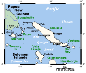
Location of Rob Roy Island (Bottom Right) and neighbouring islands

Rob Roy Island, native name Velaviru, is an islandinSolomon Islands located off the South East coast of Choiseul Island; it is located in Choiseul Province.[1][2]

Geography[edit]

The island is covered with coconut plantation and jungle. The island is 20 km long and has a summit elevation of 150 m.[3]

Nagosele Passage divides Rob Roy Island from Choiseul Island[4][5][6][7]

References[edit]

  1. ^ "Rob Roy Island: Solomon Islands". Geographic Names. Retrieved 4 August 2018.
  • ^ "Traveling Luck for Rob Roy Island". Traveling Luck. Retrieved 4 August 2018.
  • ^ http://www.solomonislands.com.sb/robroy.html googlecached version of website
  • ^ Excursion to Choiseul - Chapter Six — Page 53, Nagosele Passage, dividing Rob Roy Island from Choiseul, is in places less than 70 yards wide. Rob Roy rises steep from its waters, inaccessibly steep generally, but on the Choiseul side of the channel merges into shallow mangroved waters, providing hundreds of natural hideouts for small craft., Stepping Stones to the Solomons: the unofficial history of the 29th Battalion with the Second New Zealand Expeditionary Force in the Pacific., NZETC
  • ^ Nggosele Passage between Choiseul and Rob Roy Island experiences strong currents depending on the tides. Archived 2008-09-19 at the Wayback Machine, South East Choiseul and Vaghena, choiseul, Exploring Solomons
  • ^ Going through the passage between Rob Roy Island and Choiseul, May 12, 2009, by alan70, Panoramio
  • ^ "Going through the passage between Rob Roy Island and Choiseul". Geoview. Retrieved 4 August 2018.
  • Notes

    7°25′S 157°35′E / 7.417°S 157.583°E / -7.417; 157.583


  • t
  • e

  • Retrieved from "https://en.wikipedia.org/w/index.php?title=Rob_Roy_Island&oldid=1214856601"

    Categories: 
    Islands of the Solomon Islands
    Solomon Islands geography stubs
    Hidden categories: 
    Webarchive template wayback links
    Pages using gadget WikiMiniAtlas
    Coordinates on Wikidata
    All stub articles


    This page was last edited on 21 March 2024, at 16:34 (UTC).

    Text is available under the Creative Commons Attribution-ShareAlike License 4.0; additional terms may apply. By using this site, you agree to the Terms of Use and Privacy Policy. Wikipedia® is a registered trademark of the Wikimedia Foundation, Inc., a non-profit organization.


    Privacy policy

    About Wikipedia

    Disclaimers

    Contact Wikipedia

    Code of Conduct

    Developers

    Statistics

    Cookie statement

    Mobile view


    Wikimedia Foundation
    Powered by MediaWiki