Jump to content


Main menu


Navigation  


Main page
Contents
Current events
Random article
About Wikipedia
Contact us
Donate


Contribute  


Help
Learn to edit
Community portal
Recent changes
Upload file


Search  


Create account

Log in


Create account
 Log in


Pages for logged out editors learn more  


Contributions
Talk


Contents


(Top)


1 Transport  


2 References  


Pembroke Square, London


Italiano
مصرى
 

Edit links


Article
Talk


Read
Edit
View history


Tools


Actions  


Read
Edit
View history


General  


What links here
Related changes
Upload file
Special pages
Permanent link
Page information
Cite this page
Get shortened URL
Download QR code
Wikidata item


Print/export  


Download as PDF
Printable version


In other projects  


Wikimedia Commons


Appearance


Coordinates: 51°2948N 0°1154W / 51.496787°N 0.198320°W / 51.496787; -0.198320
 

From Wikipedia, the free encyclopedia


Pembroke Square
Pembroke Square

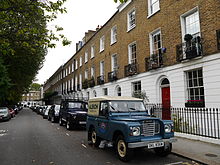
Pembroke Square is located in the Kensington area of southwest central London, England (postcode W8). The whole square is Grade II listed for its architectural merit.[1] It was developed by the Hawks family.[2]

The Hansom Cab is a Grade II listed public house on the corner with Earls Court Road.[3]

38 Pembroke Square was the house used as the surgery of Dr Hirsh in the movie Sunday Bloody Sunday.

The novelist Vernon Lee lived at No.13. Immunologist Sir Almroth Wright lived at No.6 The playwright John McGrath (playwright) and his wife, the Scottish actress Elizabeth MacLennan lived at No 33a. The artist Alfred Leete died at his home No. 34 in 1933.

Transport[edit]

There are two nearby underground stations, High Street Kensington and Earl's Court. Both stations are served by the District line which connects them to London's railway terminals.

There are also buses from High Street Kensington which go towards White City, Hammersmith and Wandsworth. London bus routes 9, 10, 27, 28, 49, 52, 70, 328, 452, C1, night routes N9, N28, N31, N52 and coach route 701/702.

References[edit]

  1. ^ Historic England, "1-20 Pembroke Square (1225930)", National Heritage List for England, retrieved 29 September 2014
  • ^ Welford, Richard (1986). Survey of London: Volume 42, Kensington Square To Earl's Court:The Edwardes Estate: Pembroke Square, Pembroke Gardens and Pembroke Road area. London County Council. pp. 268–282.
  • ^ Historic England, "The Hansom Cab (1225932)", National Heritage List for England, retrieved 29 September 2014
  • 51°29′48N 0°11′54W / 51.496787°N 0.198320°W / 51.496787; -0.198320


  • t
  • e

  • Retrieved from "https://en.wikipedia.org/w/index.php?title=Pembroke_Square,_London&oldid=1117705441"

    Categories: 
    Squares in the Royal Borough of Kensington and Chelsea
    Kensington
    Communal gardens
    Garden squares in London
    London geography stubs
    Hidden categories: 
    Pages using gadget WikiMiniAtlas
    Articles with short description
    Short description matches Wikidata
    Use dmy dates from April 2022
    Coordinates on Wikidata
    Commons category link is on Wikidata
    All stub articles


    This page was last edited on 23 October 2022, at 04:23 (UTC).

    Text is available under the Creative Commons Attribution-ShareAlike License 4.0; additional terms may apply. By using this site, you agree to the Terms of Use and Privacy Policy. Wikipedia® is a registered trademark of the Wikimedia Foundation, Inc., a non-profit organization.


    Privacy policy

    About Wikipedia

    Disclaimers

    Contact Wikipedia

    Code of Conduct

    Developers

    Statistics

    Cookie statement

    Mobile view


    Wikimedia Foundation
    Powered by MediaWiki